We’ve had many comments in response to Graeme Decarie’s Bois Franc question

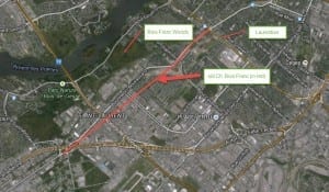
Bois Franc today. We owe thanks to Tim Hewlings (MCHS '63) for sending along this map. The source is Google Earth.

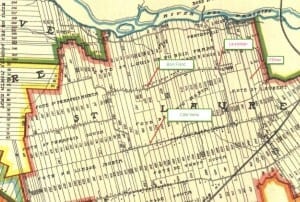
1907 map. The early map, Tim Hewlings notes, is from: A. R. Pinsoneault, Atlas of the Island and city of Montreal and Ile Bizard, s. l., The Atlas Publishing Co., vers 1907 found on the BANQ website.
We’ve had many comments in response to the following post connected to Malcolm Campbell High School:
Graeme Decarie has a question about the old Bois Franc. Do you know the answer?
Here’s the most recent comment, from Tim Hewlings of Montreal. I mention the most recent post as a way to bring attention to the ongoing discussions:
Tim Hewlings writes:
I just found the posts about Chemin Bois Franc. Here are my 2 cents worth.
Eric and Doug are correct. Bois Franc became Henri-Bourassa in the 60s sometime, I believe.
Small correction, tho’. The extended runway Doug talked about was at Cartierville airport, not Dorval. As I recall Bois Franc used to end at Chemin St-François, but I could be wrong. It could have been Montée de Liesse or Pitfield.
I seem to remember using that route to drive to Pointe Claire in those days.
This was all cut off when Hwys 13 and 40 were built.
There is still a remnant of Chemin Bois Franc between Henri-Bourassa and Autoroute 13, where some of the old farmhouses still exist. (You can find it on Google maps.)
The Northern Electric factory was at the south end of Laurentian Blvd. now Marcel-Laurin, right at the Decarie circle. The building is still there, now owned by Bombardier
The fish market was Gidney’s. Had a big sign that read “Homards – Lobsters”. I had a friend from Ontario who always called the place Homard’s lobsters.
Speaking of restaurants, you must remember the Aladin at the corner of Gouin and Laurentian, just across from the Cartierville train station. We all used to hang out there on Friday nights.
[End of text]

I remember Aladins. They had great pizza. Aladins was in a new building. Prior to that at this location, there was an old grocery store, with saw dust on the floor. One day, the train’s brakes failed coming into the station. It rammed right through the abutment at the end of the tracks and clear across Gouin Blvd. and through the front yard in front of the old building (set back about 50 feet from the street). The Ontario guy who called the fish market “Homard’s lobsters” reminds me of a visitor from British Columbia who thought that “A Vendre” was the name of someone who owned a lot of real estate in Montreal.
Yes, it was Cartierville Airport. I think I said the “runway at Canadair.” In a sense, I was right as the reason that the runway at Cartierville Airport was extended was Canadair test flights of CF-104s. Actually, the runway at Dorval was also extended in that time period as I think Montée de Liesse or Pitfield (I don’t remember which) was moved to go around it. I love the line about A Vendre!!! ROTFLMAO. Talking about Laurentian Blvd. remindsd me of St. Aubin’s Ice Cream near Barnabe Motors…
I have a question about Dorval airport that I’d like to share.
A local resident, in the Toronto neighbourhood where I live, is now in her early nineties. During the Second World War, she and her husband lived in Dorval. Her husband, a mechanic, was involved with repairing military airplanes. At that time Dorval served as a military aviation facility. I imagine that, at that time, Dorval may not yet have been devoted to much in the way of civilian aviation.
There was a kind of shuttle service in place, whereby airplanes would be flown between Canada to England, as I understand. (My understanding is limited.) Sometimes planes would be flown to Dorval on the way for repairs. On occasion, one of those planes would not make it for the landing and would crash. The local resident, one of many people in their eighties and nineties that I’ve been interviewing over the past several years, has described such an occasion for me.
I’m interested in learning more about Dorval’s role during the Second World War, with a focus on the kind of work that the airplane mechanic, that I have mentioned, would have been doing. I’ve read books about aviation history available at the Toronto Public Library, and have looked online, but have learned little about aviation history as it relates specifically to Dorval. I’m also interested in the early history of Dorval, as a community.
I would, as well, be interested in accounts, based on archival resources, in French or English, related to the early history of the Cartierville airport, and its role during the Second World War and immediate postwar era.
I’ve learned many things of interest about the military history of the communities where I now live, at the Toronto-Mississauga border near Lake Ontario, and am keen to also learn more about military history as it relates to Cartierville and nearby communities.
By way of my own personal interest in military history, the book Bloodlands: Europe between Hitler and Stalin (2010) provides a good overview of the context in which my parents grew up, in Estonia between the First and Second World Wars.
I’m pleased that Canada played a strong role on the Allied side during the Second World War. My parents managed to escape from Estonia across the Baltic Sea in 1944 as the Soviet army was closing in; I was born a couple of years later in Sweden and six years later the family arrived in Montreal where I grew up. When I was growing up, I would note at times that relatively little was known in Canada about the history of Eastern Europe. I’m pleased that now such information is more widely available, some of it based on archival resources that have been opened up relatively recently, for anybody who has an interest in such topics.
I generally stay away from Wikipedia. However, the following item from a Wikipedia entry about Quebec Autoroute 13 provides information that may help to round out the discussion:
“Boulevard Pitfield derives its name from the origin of the actual route. In the 1920s, the actual route was a Polo Pony Trail leading from the various estates of the Saraguay Village residents to their Polo Fields, now where the area of St. Laurent Blvd and Bois Franc merge. In the late 1930s the path became an unpaved local road. Over the next several decades Saraguay Farms, owned by Mrs. W.C. Pitfield, was paid to clear the road in the winter by the municipality of St. Laurent. The road was developed into a two-lane highway in the 1960s.”
June 17th 2017 Does anyone remember the following..I grewup in Ville st. laurent in the 50’s. My father was a jewish peddler with canadian outfitting co. on st. laurent..the main. I attended beth ora synagogue with rabbi morris halpern in the 60’s. I went to sir winston churchill high school in the 60’s. I lived on valade st. corner st. louis. My best friend was beverely nermeroff & candy fisher.