Three Ward 3 Candidates – Pamela Gough, Iaian Davis, and Amber Morley – answer questions about cyclist and pedestrian safety
Amsterdam, August 2018. Jaan Pill photo
A previous post is entitled:
In her third campaign item, Pamela Gough addresses pedestrian and cycling safety
Amsterdam, August 2018. Jaan Pill photo
I recently received a copy of the Oct. 18, 2018 TCAT newsletter. TCAT is the acronym for the Toronto Centre for Active Transportation.
Click here to access the Oct. 18, 2018 TCAT newsletter >
Results of “Build the Grid” survey for Ward 3, to which Pamela Gough, Iaian Davis, and Amber Morley responded
*
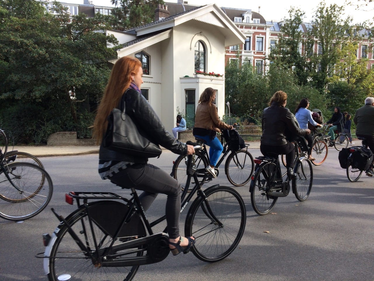
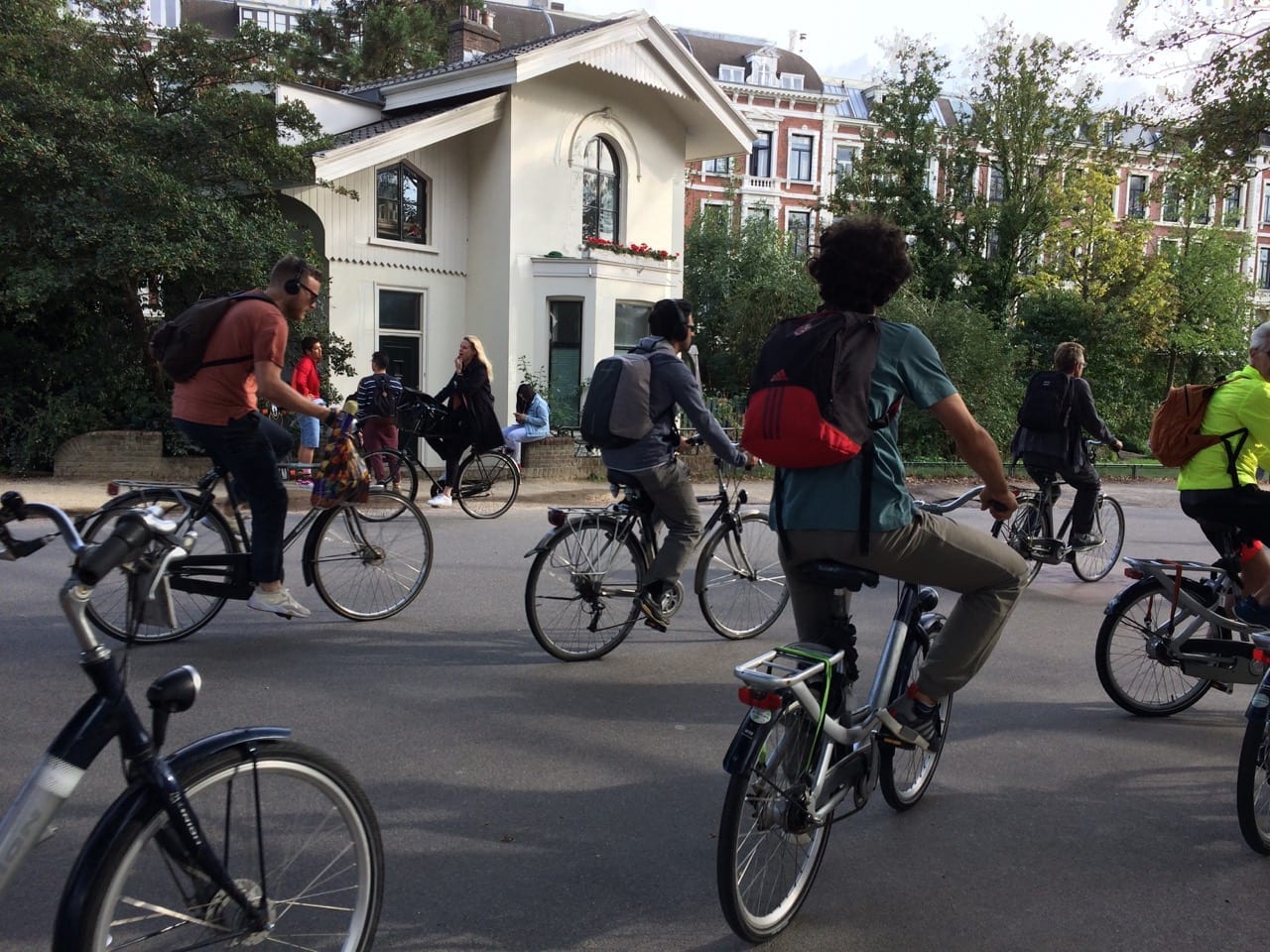
Commentary: I was astounded, on a tourist visit in August 2018, to observe the bicycle infrastructure that is in place in Amsterdam
I will preface this post with the following comments.
Unlike standard surveys, which do not call for particular responses to questions, the survey featured at the current post is structured as a form of advocacy, with questions that act as “leading questions.” That said, it may be noted that the format reflects the passion and commitment of the Toronto Centre for Active Transportation.
I am not aware of the steps, by which Amsterdam arrived at the beautifully designed – and fully functional – bicycle, pedestrian, and motor vehicle infrastructure, that I’ve highlighted at the photos featured at this post.
Amsterdam, August 2018. Jaan Pill photo
Reading of library books on the planning history of Amsterdam, that would describe how such a transportation system came to be developed, is a future project, that I would like to undertake.
I could do online research also, but generally I prefer to read books for such information. For sustained reading, I avoid screens when I can.
I would guess, based on first-hand observations in Amsterdam in August 2018, that passion and commitment, on the part of large numbers of people, would likely have played a key role, in development of the latter city’s impressive transportation infrastructure. That’s my working hypothesis, at any rate, as I start my reading about how Amsterdam developed its commendable practice, of spending a good part of each day on bicycles.
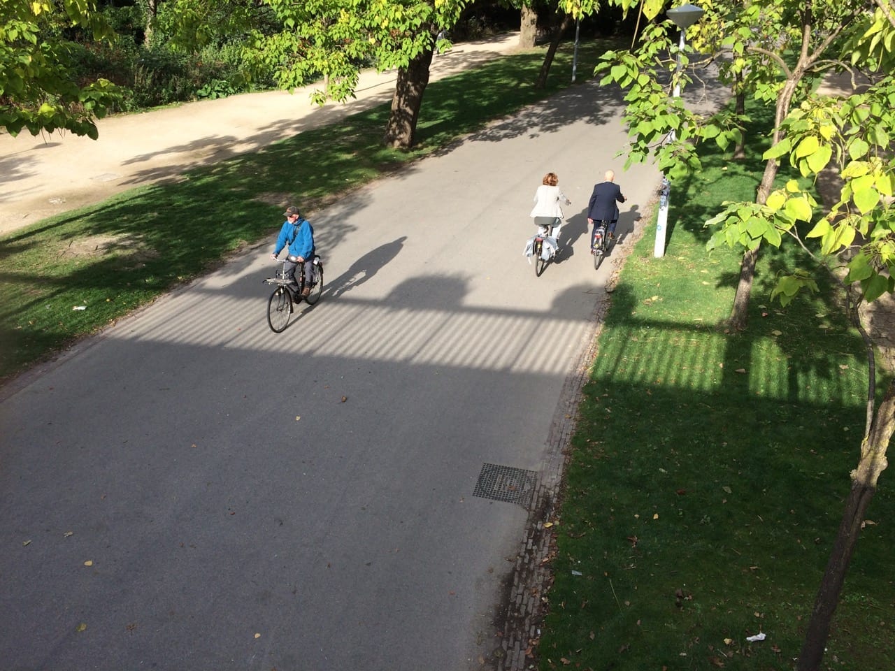
Among other things, Amsterdam bike pathways are, when required, generally delineated by particular surface treatments, and subtle differences in elevation, that clearly separate them from walkways and car thoroughfares.
What I saw in Amsterdam, over several days of close observation, astounded me. From morning until evening, I saw thousands of residents, of all ages and walks of life, contentedly perched upon bicycles – typically sitting upright rather than crouched forward over racing handlebars – travelling back and forth across the city.
Often people would ride abreast, carrying on conversations as they pedalled along on solid, standard-issue bicycles. In many cases, carts were in place in front of bikes, where young children would be sitting, carrying on their own conversations.
Some bikes were also fitted with purpose-built carts, for the transportation of goods.

Amsterdam, August 2018. Jaan Pill photo
I had never seen such a sight before, except when I was a five-year-old child in Stockholm in the late forties, where bicycles were, in the 1940s – as is now the case in Amsterdam – a standard means of everyday transportation.
After I arrived in Montreal as an immigrant, at age five in 1951, the image of hundreds of bicycles, along the streets of Stockholm, stayed with me, and has never left. I visited Stockholm as well as Amsterdam in August 2018. In Stockholm, pathways are indeed in place, to guide bicycle traffic, but the infrastructure is not as highly developed, as it is in Amsterdam.
What I saw in Amsterdam underlined for me that the bicycle infrastructure, that has so far emerged in a city like Toronto, represents but one particular way, that a given city at a given time in history, goes about its planning. Amsterdam underlined for me that, under suitable conditions, cities have the capacity to take specified steps, that make transportation safer – and by far healthier – for all of its citizens, of all ages and walks of life, than would otherwise be the case.
Amsterdam, August 2018. Jaan Pill photo
[End of commentary]
-
Do you commit to supporting the implementation of a city-wide default speed limit of 30 km/h on all residential streets and 40 km/h on all arterial and collector roads?
Speed kills: A pedestrian struck by a vehicle travelling 50 km/h is five times more likely to die than if they are hit at 30 km/h.
Bill 65, the Safer School Zones Act, passed in 2017, enables municipalities to create Community Safety Zones with blanket default speeds lower than the current default of 50 km/h. In June 2018, the Public Works & Infrastructure Committee adopted a staff report to designate all K-8 schools as Community Safety Zones. While an important first step, every Torontonian is at risk on streets across the city where excessive motor vehicle speed is permitted. Implementing lower city-wide default speed limits is a critical component in preventing traffic fatalities. We need to move Toronto closer to a city-wide speed limit of 30 km/h on all streets other than expressways.
| Ward | Candidate | Q1 Answer | Q1 Comment |
| 3 | Davis, Iain | Yes | |
| 3 | Gough, Pamela | Yes | I am very aware of the need to lower speed limits throughout the city, especially in school zones. Injury of VRUs is directly related to speed. |
| 3 | Morley, Amber | Yes |
-
Do you commit to supporting the streamlining of the traffic calming process?
Traffic calming is the deliberate slowing of traffic on residential streets by making physical changes such as adding speed humps or narrowing lanes. Traffic calming has been proven to slow traffic and reduce collisions, yet the process in Toronto is time-consuming and confusing. In May 2018, City Council delegated to Community Councils the authority to waive onerous petition and polling requirements, but there remain many barriers to implementation, including restrictive technical warrants and a complaints-driven process. Toronto needs to continue to reform and streamline its traffic calming process.
| Ward | Candidate | Q2 Answer | Q2 Comment |
| 3 | Davis, Iain | Yes | |
| 3 | Gough, Pamela | Yes | |
| 3 | Morley, Amber | Yes |
-
Do you commit to supporting the implementation of traffic calming at all elementary school zones by 2022?
Pedestrian injuries are one of the leading causes of injury related deaths for children. In June 2018, the Public Works & Infrastructure Committee adopted a staff report to designate safety zones around all elementary schools. Fines will be increased, the zones will be eligible for safety cameras (pending provincial approval), and traffic calming will be considered site-by-site. While an important first step, signage has little effect on driver behaviour. Speed humps, bulb-outs, raised crosswalks, and narrowing lanes have been proven to reduce collision rates and save lives. We need to build these solutions starting now to make the entire city safe for walking to school.
| 3 | Davis, Iain | Yes | |
| 3 | Gough, Pamela | Yes | |
| 3 | Morley, Amber | Yes |
-
Do you commit to supporting adding a sidewalk on at least one side of the street when an opportunity such as road reconstruction arises, in line with City policy?
Sidewalks are an essential piece of the City’s transportation infrastructure, providing accessibility and safety for all, including children, seniors, and people with disabilities. But nearly 25% of all local streets in Toronto don’t have a sidewalk and many more only have a sidewalk on one side of the street. Where sidewalks are missing, people have no alternative but to walk on the roadway or on unimproved road shoulders. The City’s road classification criteria recommends a sidewalk on at least one side of all local roads. Road reconstruction presents a once-in-a-lifetime opportunity to add a missing sidewalk and is the most cost-effective and efficient approach to doing so. The City’s Disability, Access and Inclusion Advisory Committee endorsed this approach for accessibility, safety and walkability reasons. But local councillors frequently oppose adding sidewalks and this results in decisions that deviate from City policy. Every street in Toronto needs a sidewalk.
| 3 | Davis, Iain | Yes | |
| 3 | Gough, Pamela | Yes | |
| 3 | Morley, Amber | Yes |
-
Do you commit to supporting a minimum 2.1 metre pedestrian clearway for sidewalks on all arterial and collector roads?
Sidewalks that are sufficiently wide allow people to walk as their primary means of transportation, in turn reducing vehicular congestion. But many of Toronto’s sidewalks are too narrow for the large volume of people that use them. Sidewalks should be open and inviting to all, regardless of age or ability. Sidewalks must accommodate people that are moving at different speeds, that are stationary, as well as people who use different kinds of mobility devices. Toronto’s Complete Streets guidelines set a minimum clear space on sidewalks of 2.1 metres to provide a safe, universally accessible path. This minimum width allows one person to pass two people walking together, and space for two wheelchairs to pass. Wider, unobstructed sidewalks benefit everyone.
| Ward | Candidate | Q5 Answer | Q5 Comment |
| 3 | Davis, Iain | Yes | |
| 3 | Gough, Pamela | Yes | |
| 3 | Morley, Amber | Yes |
-
Do you commit to supporting building protected bike lanes on main streets, including the major corridors identified in The Cycling Network Plan?
According to a 2018 Nanos poll, 11 percent of people in Toronto ride a bike every day and two-thirds of Torontonians would ride more if there was more and better infrastructure in their community. City Council adopted a city-wide 10 Year Cycling Network Plan in 2016 and it will be updated in early 2019. While the Plan included Bloor Street, Yonge Street, and Danforth Avenue as critical elements to connect the network, studies for Danforth, and Yonge St, and other major corridors were put on hold and subsequently removed from the implementation plan by Council. Torontonians across the city need a network of safe, protected bike lanes.
| 3 | Davis, Iain | Yes | |
| 3 | Gough, Pamela | Yes | |
| 3 | Morley, Amber | Yes |
-
For Council candidates, do you commit to supporting building safe, connected routes in your ward as identified in the 10-Year Cycling Network Plan? For Mayoral candidates, do you commit to supporting building safe, connected routes in each ward as identified in the 10-Year Cycling Network Plan?
In addition to main streets, Toronto’s diverse neighbourhoods need safe cycling infrastructure that connects them to schools, shopping, and other destinations. Close to half of trips made in Toronto are under 5 kilometres, making them ideal for cycling if safe, connected routes are in place. Torontonians need safe cycling infrastructure across the entire city, connected to places they need to go, as identified in the 10-Year Cycling Network Plan and Vision Zero Road Safety Plan.
| 3 | Davis, Iain | Yes | |
| 3 | Gough, Pamela | Yes | |
| 3 | Morley, Amber | Yes |
- Do you commit to supporting accelerating the Cycling Network Plan to be built in the next four years?
An Angus Reid Forum poll shows that 86% of Torontonians support a safe cycling network. The City is currently studying the cost of accelerating the Cycling Network Plan to be built by 2022 i.e installing 335 kilometres of on-street protected bike lanes and 190 kilometres of bike boulevards in six years. For comparison, New York City installed 643 kms (400 miles) of bike lanes in six years. We estimate that a $25 million annual capital budget could make the 2022 target a reality. This could be achieved from 2019 forward with the City Council-approved commitment of $16 million per year plus $8 million already committed to Toronto by the Province. Speeding up implementation of the Cycling Network Plan will save lives and prevent life-altering injuries.
| 3 | Davis, Iain | Yes | |
| 3 | Gough, Pamela | Yes | |
| 3 | Morley, Amber | Yes |
-
Do you commit to supporting increasing the use of automated traffic enforcement safety cameras?
Red light cameras, first introduced in Toronto in 2000, have been reported by the City of Toronto to reduce instances of crashes and injury by up to 60% in the intersections where they’ve been implemented. Toronto’s Vision Zero Road Safety Plan increases the number of safety cameras at red lights from 77 to 153 by 2021. The goal of the plan, as adopted by Council, is to “reduce the number of road fatalities and serious injuries to zero as part of the five-year Road Safety Plan.” Accelerating the implementation of automated safety cameras would save lives.
Read more
| 3 | Davis, Iain | No | |
| 3 | Gough, Pamela | Yes | |
| 3 | Morley, Amber | Yes |
-
Do you commit to supporting prioritizing the safety of vulnerable road users by outlawing motor vehicle right turns on red?
Drivers who make a right turn on a red light without coming to a complete stop first, as established in the Highway Traffic Act, create a particularly dangerous environment for vulnerable road users, especially people with visual impairments, children and seniors. As drivers look left for a gap in traffic, they are more likely to strike a pedestrian or bicyclist crossing on their right. The third most common type of pedestrian collision is when a motor vehicle turns right while the pedestrian was crossing with the right of way at intersection. And 13% of pedestrian injuries or fatalities were the result of right-turning vehicles. Other large cities in North America such as New York, Montreal and Mexico City have implemented a city-wide ban on right turns on red. Prohibiting turning right on red in Toronto would make intersections safer for pedestrians.
| 3 | Davis, Iain | No | |
| 3 | Gough, Pamela | Yes | |
| 3 | Morley, Amber | Yes |
-
Do you commit to supporting a controlled crossing at all bus and streetcar stops?
In some parts of Toronto, the distance between traffic signals is 1 km or more. Many important destinations, such as transit stops, are midway between traffic lights requiring a detour of 15 minutes or more on foot to access a safe crossing point. In January 2018, a 21-year-old student was killed at such a location as she was trying to cross from a TTC bus stop on Steeles Ave. E., 300 metres away from the closest signalized intersection, with no sidewalk. Inaccessible bus stops far from crossings and with no adjacent sidewalks are not uncommon in several parts of the city, including near schools. Every TTC stop needs a safe way for people to cross the street.
| 3 | Davis, Iain | No | |
| 3 | Gough, Pamela | Yes | |
| 3 | Morley, Amber | No | Generally this is a good idea however it may be cost prohibitive to fully implement and need to be further evaluated on a case by case basis. |
-
Do you commit to supporting an implementation strategy for Toronto’s Complete Streets guidelines?
In August 2014, Toronto City Council adopted a Complete Streets policy within its amended Official Plan, and in January 2017, Toronto’s Complete Streets Guidelines were released. These guidelines are an excellent resource to ensure that the needs of all road users are reflected in street design. However, the City does not have dedicated staff responsible for developing an implementation plan. Toronto needs a Complete Streets implementation strategy, including training for staff and contractors involved in this new approach to street design and delivery.
| 3 | Davis, Iain | Yes | |
| 3 | Gough, Pamela | Yes | |
| 3 | Morley, Amber | Yes |
- Do you commit to supporting the Transform Yonge option for Yonge Street between Sheppard and Finch Avenues?
The population density between Finch and Sheppard Avenues has become comparable to Toronto’s downtown core, resulting in high volumes of people moving by all modes. North York Centre continues to grow and requires a multi-modal Complete Street that will accommodate increasing numbers of pedestrians and cyclists, yet still allow for the efficient movement of vehicles. In the Reimagining Yonge environmental assessment study, City staff recommended the “Transform Yonge” option that would reduce six vehicular lanes to four, install bike lanes, and increase sidewalk widths. In March 2018, City Council deferred consideration of the Reimagining Yonge staff report to a later date. By adopting the “Transform Yonge” option, Council would make Yonge Street safer and more accessible for vulnerable road users and provide active transportation options that will help generate significant health, economic and other benefits.
| 3 | Davis, Iain | Yes | |
| 3 | Gough, Pamela | Yes | As a trustee, I moved a motion at TDSB Planning and Priorities Committee to have the TDSB support the Transform Yonge project shortly before it was debated at City Hall. This stretch of Yonge Street basically operates as a highway at present and is close to several large schools so many students are crossing the roads. Unfortunately the motion was not passed since the other trustees did not feel knowledgeable about the issue and they felt it was not their jurisdiction. |
| 3 | Morley, Amber | Yes |
- Do you commit to supporting increasing the City of Toronto’s budget for achieving zero traffic deaths to $107M/year, which would bring it to the same per-capita level as New York City’s Vision Zero Action Plan, considered a leader in North America?
The City of Toronto has committed $80.3 million over five years, or $6 per capita per year, to its Vision Zero Road Safety Plan (2016-2021). New York City has committed $1.3 billion over four years (2017-2021) to its Vision Zero capital budget, or $38 per capita per year. In 2017, New York experienced its fourth consecutive year of declining traffic fatalities (the fewest number of lives lost since 1910) while Toronto’s number of deaths is on the rise. Toronto needs to move more quickly to implement the Vision Zero Road Safety Plan.
Read more about Vision Zero in New York.
| 3 | Davis, Iain | Yes | |
| 3 | Gough, Pamela | Yes | Yes. The City of Toronto Vision Zero plan has not been successful in reducing fatalities of VRUs largely because of lack of political will. If elected I will fight for faster implementation of countermeasures especially in school zones. |
| 3 | Morley, Amber | Yes |
- Do you commit to supporting and funding a monthly Open Streets Toronto program from May to September in 2019 and beyond?
Open Streets are programs that temporarily open streets to people by closing them to cars for people to walk, bike and be physically active. Since 2014, Open Streets Toronto has collaborated with the City of Toronto, community organizations and sponsors, to deliver a grassroots program, which opens a 6 km stretch of Yonge and Bloor Streets to people for 2-3 Sunday mornings per year. The most successful international examples have significant funding from their City governments and are regularly occurring programs. The City of Toronto has contributed only about 8% of the total program budget in 2017 (the cost of one open street is $150,000). A regularly occurring Open Streets program, with sustainable funding from the City would provide economic, health, and environmental benefits on an underused asset – our streets.
| 3 | Davis, Iain | Yes | |
| 3 | Gough, Pamela | Yes | Yes. Streets are built by tax funds contributed by all, and closing them down to cars from time to time reclaims them as public space and allows them to be used for community building. In NYC, there has been a long standing program of Play Streets in areas poorly served by green space. Started 100 years ago out of the firm and widespread conviction that urban children needed to be able to play outside, it still continues today. It’s another form of Open Streets. |
| 3 | Morley, Amber | Yes |
TCAT has surveyed candidates on active transportation issues for every municipal election since its founding in 2006. See our past election surveys.
[End]
Click on photos to enlarge them; click again to enlarge them further
Among the books I’m looking forward to reading, regarding the steps by which Amsterdam made bicycling a safe, efficient, and enjoyable pursuit for its residents, is a book in the juvenile literature category:
Pedal power: how one community became the bicycle capital of the world (2016)
A blurb for the book at the Toronto Public Library website reads:
Cycling rules the road in Amsterdam today, but that wasn’t always the case. In the 1970’s, Amsterdam was so crowded with vehicles that bicyclists could hardly move, but moms and kids relied on their bicycles to get around the city. PEDAL POWER is the story of the people who led protests against the unsafe streets and took over a vehicles-only tunnel on their bikes, showing what a little pedal power could do! Author and illustrator Allan Drummond returns with the story of the people that paved the way for safe biking around the world.
Also of interest:
Pedal power: the quiet rise of the bicycle in American public life (2008)
A blurb reads:
This book examines the surging national interest in bike-friendly public policies and argues that this growth is likely to escalate. Currents in U.S. culture that have supported the dominance of the car are edging toward exhaustion. At the same time, other factors including congestion, contentious and unreliable energy resources, rising pollution, and global warming support the expansion of the bike’s use. A surprising array of political organizations, visionary politicians, and colorful individuals powers this movement.
As well:
Velotopia: the production of cyclespace in our minds and our cities (2017)
A blurb reads:
Across the world, cities are encouraging cycling to make their centers livable again
Could cycling actually become a key organizing principle for future urban growth and the design of new buildings? What would cities designed for cycling look like and feel like? What is needed to make the perfect cycling city?
In Velotopia: The Production of Cyclespace in Our Minds and Our Cities, architectural theorist and historian Steven Fleming, a leading international figure in bicycle urbanism and author of the bestselling Cycle Space (2013), argues that the best-connected cities in the future will be those that put cycling before walking and public transport. According to Fleming, cities organized around cycling will be greener and healthier, but also fairer and more accessible than today’s cities–more productive, comfortable, social and fun. In this volume, Fleming dares readers to think big, to radically reimagine cities and city life around movement on two wheels.
The first bike-centric model of urban planning and building design, Velotopia is a book for designers, planners, students, advocates and the general reader–all those shaping cities and the built environment who imagine a future for the cycling city.
[End]
Amsterdam urban planning
A search at the Toronto Public Library website for “Amsterdam urban planning” yields other titles, mostly under the “Reference only” category.
Among the books on this list that can be borrowed is:
Metropolis: mapping the city (2015)
A blurb reads:
The city: a place of hopes and dreams, destruction and conflict, vision and order. The first city atlas, the Civitates Orbis Terrarum, was published by Braun and Hogenburg in 1572 for the armchair traveller interested in a world that was opening up around [her or] him. Since then our fascination with foreign cities has not abated. This sumptuous volume looks at the development of the mapping and representation of the city revealing how we organize the urban space. From skyline profiles, bird’s eye views and panoramas, to the schematic maps of transport networks and road layouts to help us navigate, and statistical maps that can provide information on human aspirations, cities can reveal themselves in many ways. Focusing on key points in the development of urban representation and including visions of the future of how we would be living today, this enlightening book illustrates some of the oldest, youngest, liveliest, and most contested cities in the world.