Second Long Branch Jane’s Walk, on May 5, 2013 explored the Mississauga-Toronto border south of Lake Shore Blvd. West
The weather was perfect for the second Long Branch Jane’s Walk, held on May 5, 2013, which took us from Marie Curtis Park to Colonel Samuel Smith’s homestead site, and from there to the Fair Grounds Organic Cafe and Roastery at Forty First Street and Lake Shore Blvd. West.
The first Long Branch Jane’s Walk, on May 4, 2013, went from Marie Curtis Park to the Lakeshore Hospital Grounds as we’ve discussed in a previous blog post.
We began our May 5 walk, with 27 attendees, with a visit to the cannon on the boardwalk between Forty Second Street and the current channelized version of Etobicoke Creek.
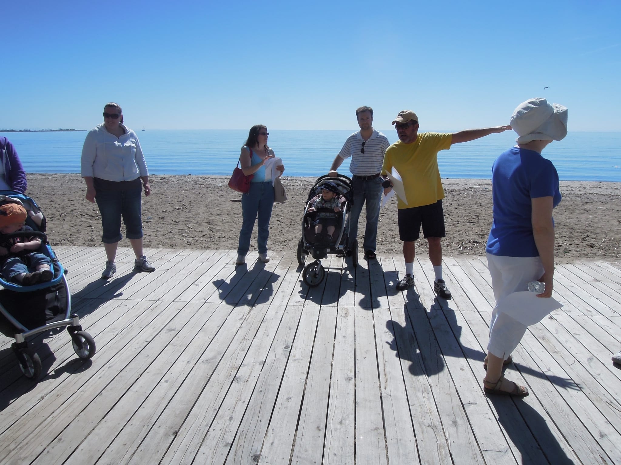
Mike James indicates where Lake Promenade used to extend in the years before this former cottage area was turned into Marie Curtis Park as an aftermath of Hurricane Hazel. Jaan Pill photo
Mike James noted that after years of action, a cannon’s barrel gets reduced in thickness, making it potentially dangerous to gun crews. In their retirement phase, some cannons used to end up as decorations in parks.
The retired heavy gun at Marie Curtis Park was one of five retired guns originally sent to Riverdale Park, in the Lower Don River, after a Toronto alderman had in 1881 requested some cannons from the Minister of Militia and Defence. One of the five eventually found its way to Marie Curtis Park.
Mike James noted that if you want something, it’s always a good idea to make a request, as the alderman did in 1881.
The architect A. Gresley Elton designed many public buildings in Long Branch
Among the attendees at the May 5 walk were Sid and Jane Olvet of Oakville. Jane Olvet lived in Long Branch for many years starting in 1941.
Her father was the noted architect A. Gresley Elton of Murray Brown and Elton, who among other things designed the Long Branch Public Library, the most recent version of James S. Bell School, and several other buildings including the Parkview School building at 85 Forty First Street (earlier the site of the Colonel Samuel Smith homestead) and two buildings at Marie Curtis Park.
Certain design details were a form of architectural signature signifying a building designed by A. Gresley Elton, such as the design detail seen in a photo (below) from the front of Parkview School (currently named St. Josaphat Cathedral School).
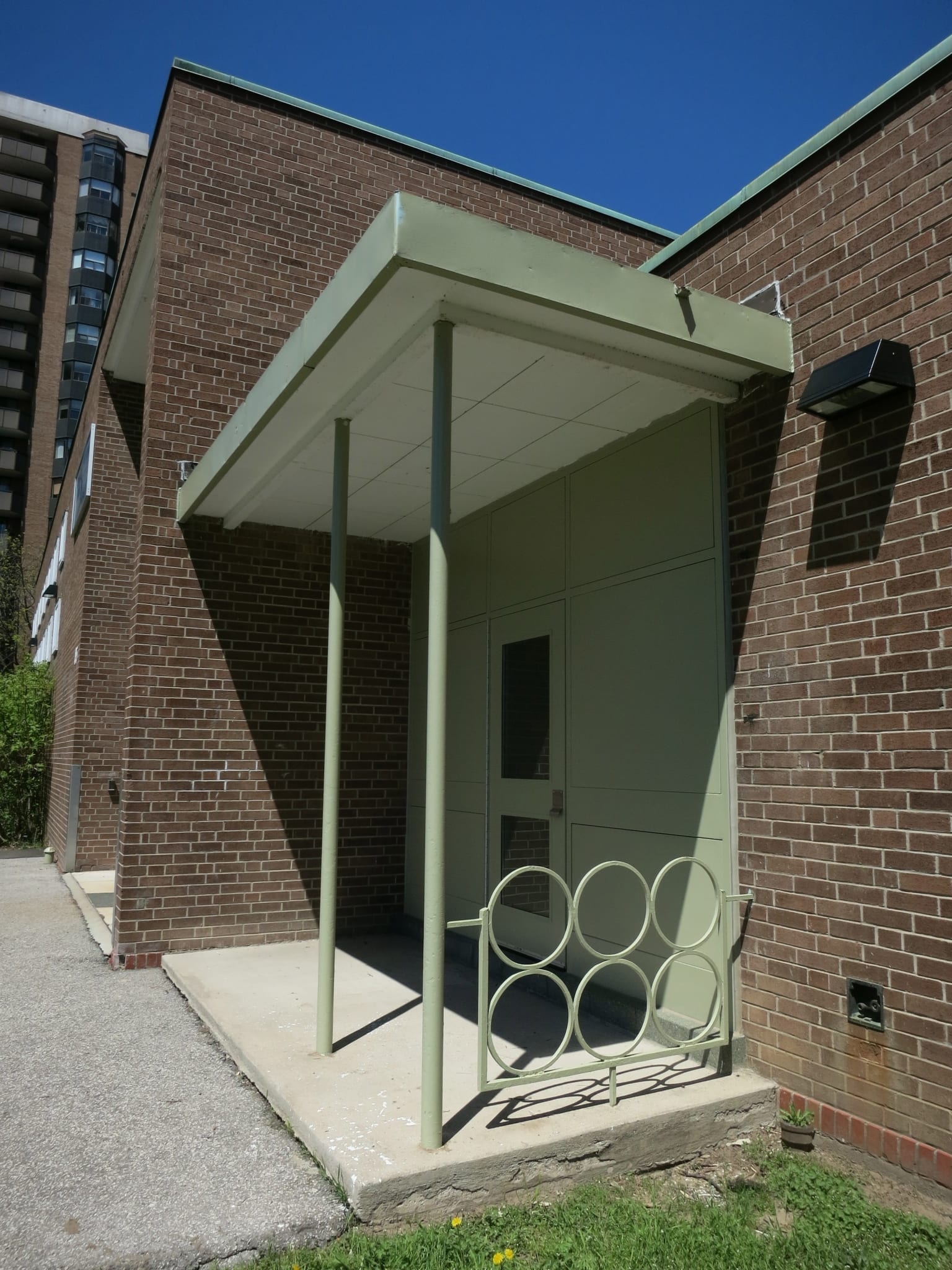
Architectural detail, characteristic of the work of A. Gresley Elton, Parkview School, 85 Forty First Street. Jaan Pill photo
New pathway east of East Parking Lot
From the cannon, we moved to an area to the east of the East Parking Lot at Marie Curtis Park. The position of the pathway had been moved westward from its previous location some months ago. The new pathway that was built in its place is several inches above the level of the nearby grass.
After it was built, the area between the new path and Forty Second Street witnessed the creation of a stagnant body of water where local geese and ducks liked to swim about.
The pond appeared to be the result of a dam created by the new pathway. Some time later, however, work crews dug up part of the path and installed a drain pipe, which appears to have addressed the flooding problem that had developed in the area.
The story gave rise to good-natured commentary related to what one person described as the Law of Unintended Consequences.
We next moved to where the Mississauga-Toronto border, south of Lake Shore Blvd. West, is now located. The border is just west of where Applewood Creek now empties into Lake Ontario, which is also where the southern channel of Etobicoke Creek used to flow into the lake.
We also discussed plans, as part of the Mississauga Waterfront Connection Environmental Assessment Project, as discussed elsewhere at this website, to remove the sand beach that exists between Etobicoke Creek and Applewood Creek, and to build in its place a meadow, wetlands, and a pebble beach. This topic gave rise to additional discussion.
Long Branch Aerodrome
We discussed, as well, the Long Branch Aerodrome – Canada’s first aerodrome – and the munitions plant and Avro Arrow testing facility that used to exist nearby in Mississauga.[1]
It was noted that the distinguished writer William Faulkner received flight training during the First World War at the Long Branch Aerodrome. It has been written that he wrote highly exaggerated letters home describing various feats and near-misses that he claimed to have been involved in as a student pilot. It has been suggested that his letters may have marked the beginning of his career as an outstanding fiction writer.
Willow and white pine
It was noted that some willow and white pine trees still stand, as they stood during the era when the area west of the current version of Etobicoke Creek had been part of the Long Branch cottage community. The trees were landmarks when cottages existed in the area, and they serve as landmarks now.
On our way toward the Fair Grounds Organic Cafe and Roastery, we also had a tour of the Aquaview Condominiums site where, as Mike James explained with the aid of a hand-drawn map, Arnold’s Restaurant and varied other key establishments in the lives of young people in the 1960s and 1970s had been located.
At the Parkview School site, Jaan Pill explained the story of Colonel Samuel Smith’s log cabin, built in 1797 and torn down in 1955. Extensive information is available elsewhere at this website regarding the colonel’s homestead, under the Colonel Samuel Smith Category.
We were very pleased that the walk began and ended pretty close to the scheduled times. The response to the event was consistently positive. People – including the two walk leaders – were very pleased with all the new things they had learned, and with all of the great exchanges of information that had occurred.
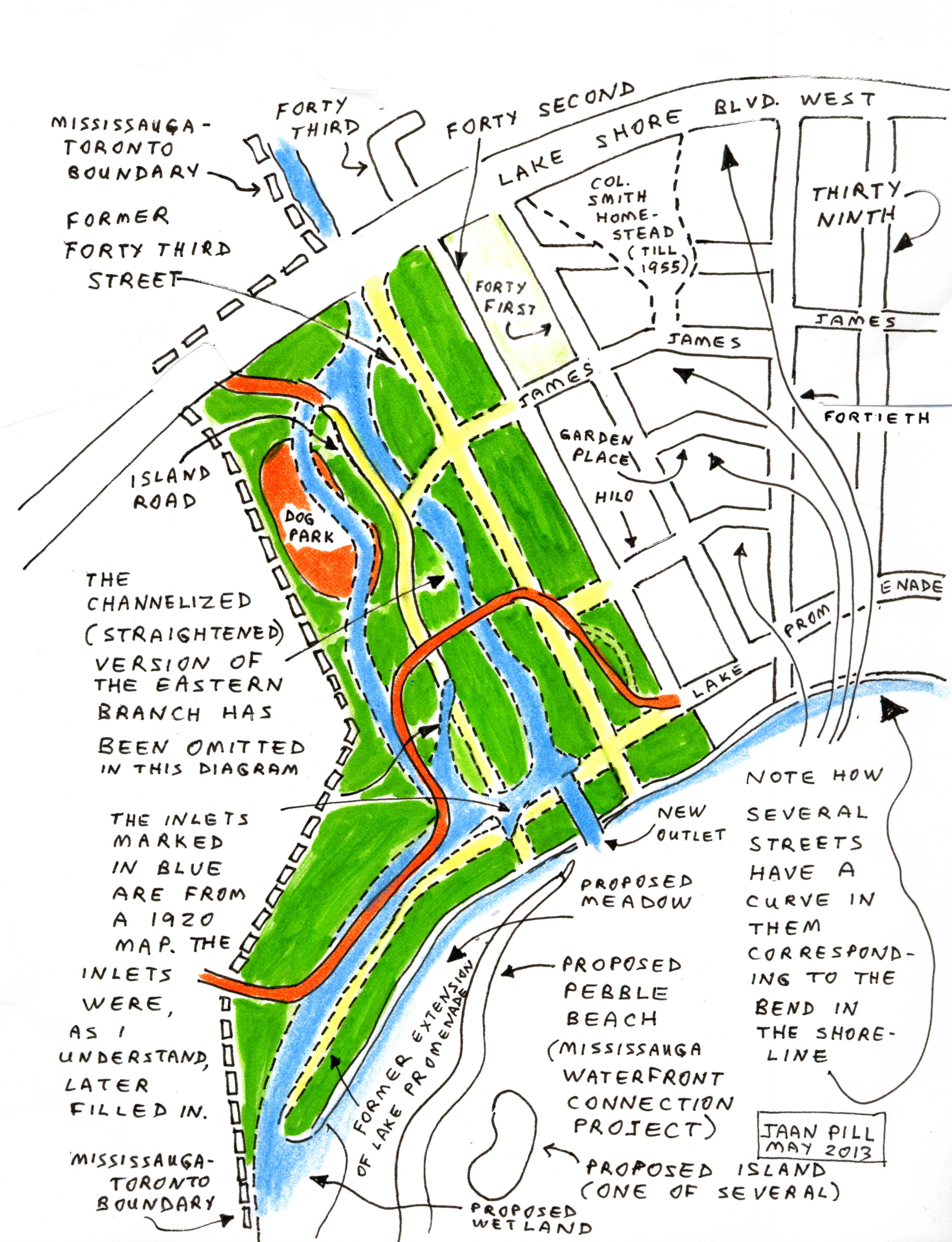
Mississauga-Toronto municipal boundary
A primary topic of interest for the second Long Branch Jane’s Walk was the fact that south of Lakeshore Blvd., West, the Mississauga Toronto border is at a point far to the west of where the channelized version of Etobicoke Creek is now located.
Given that north of Lake Shore Blvd. West, we know that Etobicoke Creek marks the Mississauga-Toronto boundary, would not the same concept apply with regard to the Mississauga-Toronto boundary as it exists south of Lake Shore Blvd. West?
The concept would indeed apply if the current version of Etobicoke Creek, as it approaches Lake Ontario, happened to be the original version of the creek.
As it happens, however, the current channelized version of the creek is a recent version of the waterway.
Prior to the creation of Marie Curtis Park following Hurricane Hazel, which devastated the area in 1954, south of Lake Shore Blvd. West the creek had a western channel as well as a southern channel.
The latter channel flowed a significant distance to the west, as the diagram below indicates.
The municipal boundary in this area is delineated by a line drawn slightly to the west of where the western channel of Etobicoke Creek used to run in the past, and slightly north of where the southern channel used to run toward what is now Applewood Creek.
The following diagram, part of a package of handouts distributed at the May 5, 2013 Long Branch Jane’s Walk, explains the story:
Leave a Reply
Want to join the discussion?Feel free to contribute!
Not mentioned in the description of the original alignment of Etobicoke Creek prior to the new channel being built to allow the creek to flow directly into the lake; On the North East corner of the bend to the right, where Lake Promenade ended, stood Scott’s boathouse. Boat rentals, Ice Cream and boat sales. Peterborough cedar strip boats and, Scott Atwater outboard motors. On the Southwest corner (lakeside) was Mrs. Oates Pavilion, Ice Cream, Snacks and, i believe dancing on weekends.
The piers constructed during the channel straightening of 1949/1950 were destroyed at a later date, perhaps during Hurricane Hazel or during one of the spring floods prior to Hazel.
I notice elsewhere that mention is made of the Etobicoke Creek Flats being raised during the development of Marie Curtis Park. On the East side of the Creek, the raised elevation was limited to filling in from the raised Hwy#2 down to about midway between the highway and James Street as it existed at the time. You can still see the depression in the ground where James Street continued from 42nd. street to the Creek. On the west side of the creek the raising of the elevation was much more ambitious, again filling in from the raised highway almost to the beach area. The lagoon and the back rivers were completely buried at this time with only a minor inlet at the original mouth of the creek.
It’s a delight to be learning more about Scott’s Boathouse and the Mrs. Oates Pavilion.
Bernice Law has described for me, in a recent interview, how the configuration of the land in the area of what is now Marie Curtis Park has changed since the 1930s. The additional details from David Webster are very valuable. I look forward to learning more, and finding a way to represent this information visually.
Note 1
Avro Arrow
A Sept. 19, 2023 CTV News article is entitled: “What really happened with the fabled Avro Arrow? Long-secret information revealed.”
An excerpt reads:
OTTAWA – The Diefenbaker government’s 1959 decision to scrap the fabled Avro Arrow was significantly influenced by Canadian intelligence that pointed to a diminishing need for the costly aircraft in the evolving Cold War, says a new research paper based on previously secret information.
The intelligence highlighted the Soviet Union’s shift away from manned bombers to long-range ballistic missiles, suggesting interceptors like the Arrow would increasingly play a smaller role in the defence of North America.
The paper makes the case that these strategic intelligence assessments – long the “missing dimension” in the debate over the Arrow’s demise – now allow for a fuller understanding of an important episode in Canadian history.