Graeme Decarie has a question about the old Bois Franc. Do you know the answer?
We’ve had some additional recent comments at the following posts:
We also have a new photo (below on the right; please see comments at the end of this post). Stephanie Brochocki writes (Aug. 14, 2022): “Despite my young age (1-2) at the time, I have very fond memories of Bois Franc. Here are two photos. Unfortunately it shows very little of the dear old house, but you can catch a glimpse of Bois Franc in the background.”
Stephanie Brochocki writes (Aug. 14, 2022): “Despite my young age (1-2) at the time, I have very fond memories of Bois Franc. Here are two photos. Unfortunately it shows very little of the dear old house, but you can catch a glimpse of Bois Franc in the background.”
Here are two comments from Mr. Decarie concerning the old Bois Franc road:

Bois Franc today. We owe thanks to Tim Hewlings (MCHS ’63) for sending along this map. The source is Google Earth.
First comment:
Back in the haze of memory, I recall an area called Bois Franc where my father would take me hiking. I’m not sure whether that was in the Cartierville-Saraguay area that we were talking of earlier or in Ahuntsic.
Does anybody know?
And I well remember Bob Carswell from my YMCA days when I was assigned to a youth group at Cartierville school. He drove me crazy with constant demands that we play some game called “buck-buck”.
Additional comment:
I am hopelessly confused. I’ve been looking at a recent map of Ahuntsic to Saraguay. And I can’t figure it out.

1907 map. The early map, Tim Hewlings notes, is from: A. R. Pinsoneault, Atlas of the Island and city of Montreal and Ile Bizard, s. l., The Atlas Publishing Co., vers 1907 found on the BANQ website.
There is a Bois Franc on the map. but it seems to be right on the border of the old airport. And it seems very small. The bois that I hiked in as a kid was much bigger, and a bit further to the north and west. So that small bois may be all that is left of Bois Franc. Or, it may be that a much larger woodland now called bois-de-liesse is a renamed remnant of the old Bois Franc.
A street called Noorduyn runs along what I think was the north end of the airport where the Noorduyn factory was, right at the intersection with Cure Labelle.
Also on Cure Labelle and across the street from Belmont Park, was a great shack selling hot dogs and fries. Loved it.
[End of comments from Graeme Decarie]
Leave a Reply
Want to join the discussion?Feel free to contribute!
Mr. Decarie
Way back in the day when we were both younger, I had you for history. On one of your exams you asked for 3 facts about certain historical figures. One of the people you asked about was a man by the name of de Salaberry and as one of the facts about him I wrote there was a street named after him. This was actually a fact but you refused to give me a mark for it. I still think it was mean of you.
However, in regard to your question about Bois Franc. (I guess I know more about streets than history) Back in the late 50’s and early 60’s, Bois Franc Boulevard was the street that ran parallel to the CN Rail line that went from Montreal to Two Mountains. It was the first street south of the tracks and ran east from Laurentian Boulevard to Filion where it stopped at a field and west from Laurentian parallel to the Canadair Airport runway. It ended just past the runway and there was nothing but bush and field after that. In the early 60’s a new subdivision went up just where Bois Franc curved to the north. One of the first streets in that subdivision was Toupin. It ran north of Bois Franc to Gouin Boulevard
That area is so built up and changed now, none of us would recognize it. The number 13 Highway cuts right through the whole place.
Hope this answers your question a bit.
Pete Mearns
Hello,
I believe part of the original Bois Franc Road became Keller later on as the area developed.
Also, I believe Henri Bourassa figured in to the most eastern connection as well. Just a vague memory, used to ride my bicycle up there. Then later when in High School (MCHS) used to play softball up in the Noël Parks (one was Noël North the other Noël South). Maybe someone else remembers this?
I know that Bois Franc was the name of a road that went past the old Cartierville Airport field and factories there like Norduyn. The road went east no further than O’Brien Bd, if that far. In other words, Bois Franc never reached Ahuntsic. At its other end, Bois Franc road may have gone as far west as Pitfield Road. Or connected up with a road with a different name that went to Pitfield Road.
I was looking at an old map recently and noticed a road or area on it called Cote St. Louis OR Bois Franc. The word “OR” actually appeared on the map. The area/road would be in the Cartierville/Saraguay area, about ½ mile south of & parallel to Gouin; and,a few hundred yards south of the CNR tracks that went from Val Royal to A Ma Baie. I’m guessing Bois Franc was the name of an wooded area before it also became the name of a road, although they could have got named “Bois Franc” simultaneously. The road/area would have been a few miles long, east/west.
I used to run along Gouin, from Laurentian to Pitfield Road, then along Pitfield to Bois Franc Road (or the road that extended Bois Franc), then east along the latter roads to Laurentian and then south Gouin. I remember it worked out to a 12 mile run and I ran it in about an hour. I was about 17 years old.
Buck-buck was a very barbaric, dangerous game. I’ll let Bob Carswell provide the details.
There were two establishments purveying hot dogs/fries, etc across the street from Belmont. One of these places was a “greasy spoon” called “Philip & Joes”. It was very popular with locals back in 1953, being one of the few places in Cartierville that had a TV where hockey fans would go and watch Quebec Minor League hockey games on Sunday afternoons. The other place, across from the entrance to the Park, was known as “Coney Island”. One could “dine”seated indoors there or standing at a counter facing the street.
Cure Labelle? That sounds like the name of a road on the other side of the Lachapelle Bridge.
Pitfield is the extension of what was Montée de Liesse where Bois Franc ended. At the other end, it ended east of O’Brien by Poirier Park in St. Laurent. Eventually it was connected to Henri Bourassa, I believe. Bus Franc originally went straight west from Laurentian Blvd. to Montée de Liesse. It looped around Cartierville Airport when the runway was extended for military jets being built at Canadair eg CF-104s. Curé Labelle was the name of the highway from the Cartierville Bridge in l’Abord à Plouffe (now Laval).
I lived on la Rue Bois Franc from 1966 to 1973. On the west side……it came off of Pitfield (which was an exit from #1 freeway, east of that Fairview Shopping Centre?) and Pitfield went north towards Gouin Blvd. and I’m not sure if it went that far north.
The next exit east would be Cote Vertu….and there were farms between the two, with a fruit stand where I could get 2 paper bags of groceries, fruit, veges, and eggs for $3.00….this is about where Cavendish Blvd. now has cut through it all in the opposite direction (north and south) ….and Bois Franc ran east along acreages of old homes and farms, .until a point at a place where my neighbours….(everyone was french, and I had to take their school bus to meet the city bus to get to MCHS), and those neighbours of mine had a little family chicken farm, and that is where it turned north at a complete perpendicular angle…like a T intersection, and you had to turn left and it after a short while turned right on a curve….around the Cartierville airport for cadets……passed Ayerst Labratories, I believe on the left, and then pass a newer subdivision before a larger street (D…something?) with a little mall including a grocery store, where I put coins into a music machine on the counter at a restaurant where I had ice cream floats.
At this street the city buses started…..and on the left side, went past a tavern for men only, and Peter School or somethings for the mentally retarded…..before we said Down’s Syndrome….that my mother would bring her German Sheperd to for them to visit with, (the airport buildings were on the right) and it went to that street in which they’ve changed the name, Laurentian Blvd…..that runs north and south past General Electric, etc., to the Decarie/ #1 TransCanada Hwy loop near Kraft and Weston Bread?.
(Going backwards, here, harder to imagine but, there was a little section about a block long that went straight from the T intersection, or from the perpendicular turn where most people turned left, and this little street section ended, as it hit the airfield…..and that’s where I lived…..in the middle of no where, above the Bergeron Animal Hospital with horse barns, stables, corrals and a riding ring.
There were remnant foundations of old homes at the end on the right side where I played and a home on the left side after mine where David and Paul Price lived who were smart handsome light skinned blacks that were A students. My home was 150 years old then, in the 60’s! It had thick bay windows facing the brussel sprout fields…..which had bushes every so often separating large sections of lines of veges….and I made little round huts with wooden vege boxes for my “club house” and art room where I sat and did drawings in pencil.
On the animal hospital farm, in which we treated cows, horses, birds, ostriches, deer, lions, flamingo’s, monkeys, and cats, and dogs, etc., we had plum, crab and McIntosh Apple trees and rhubard and an acre back yard on 5 acres all together. The vet also made corrals of government land un-used, and it was there untl about ’74 when some jerk burned down the barns with the horses in it after my mother moved out and no one was there at night. The government took back all that land which the vet had been renting.
Once I went back and it overgrown nature and hard to find. There were brussell sprout fields, with tractor trails around them, and that is how I decided to change schools…to go to Sir Winston Churchill, because I could bicycle or snowshoe to school easily through the field trails to the raw forest behind the school and through it).
I also had to cross the airfield to get home if my mother didn’t pick me up as there were no public buses. Yes, I had to run from an oncoming plane once, and a skunk and went through hip high snow, one leg lift at a time! (I’m 5’10 1/2). The airstrip provided a little break where it was ploughed.
I saw a weasel kill a rabbit in the forest. It was quite a different life from a mile away. Anyway….I’m not computer saavy, so if this isn’t posted properly, I’d love a copy…sent to me. I don’t often write about the past. Speaking of, Mr. Geoffrion…who worked at the animal hospital….wow!
A little dedicated man worked in the stables for years sometimes more than 12- 16 hrs. a day for $60. a week, walking a mile to the hospital to and from daily, 7 days a week. His wife was in a wheelchair required his home keeping as well to raise 5 boys in a little home.
I eventually took over the kennels and dog/ cat care, as horses was his thing. It enabled me to buy my first saxophone. His boys bought him his first vehicle for his 65th birthday. It was a one speed bicycle. He was the defintion of strong.
These are wonderful descriptions from so many great sources.
A question for Peter, Eric, Heather, and Janet:
Can you create a hand-drawn may to add to your description? Or do you have access to old maps that show the areas you’ve described?
If you do, would you be able to scan it and send it to me as a PDF or JPEG file? If you can, then I would be able to post the images (I would be using JPEG to post images, but it’s easy for me to convert a PDF file to JPEG in the event I receive a PDF file).
It will take time….as I am swamped with work…….and responsibility of more urgent requirement but I could probably send hand drawns and photographs of the barns/ property. Whoops, the 7th paragraph ends with an unnecessary parenthesis half.
I look forward to your map, when time permits. I await a map from you with interest. I know you’ll get around to it. As the expression goes: “If you want something done, ask a busy person.”
The opening parenthesis starts at the fourth paragraph and the closing parenthesis is at the end of the seventh paragraph. So technically, it works fine. However, if you would prefer to remove the parentheses, or make any other changes, let me know.
In the event you – or anybody else who has posted items at this site – would like to do any copy editing of your text, just send me the corrected version by email at jpill@preservedstories.com or tell me in an email what you want to have changed, and I will correct the text that is in the post. It’s a simple process and doesn’t take much time.
I beg to differ with Pete Mearns in two respects regarding Bois Franc Road: (1) it was never Bois Franc Boulevard, although later portions of it became known as Henri Bourassa Boulevard; (2) the eastern end of Bois Franc didn’t go as far as Filion in the late ‘50s/early ‘60s because Filion was then a dead end street, accessible only off Dudemaine; (3) going west along Bois Franc Road in those days, one could reach Pitfield Road: a few hundred yards after passing the Noorduyn factory, Bois Franc turned south (possibly changing its name) for about 1/3 mile and then west again for a mile or so until reaching Pitfield Road [I say possibly because by the mid ’70, this section of road with the turns in it was called Bois Franc Road and the road that went parallel to the CNR tracks and past Cartierville Airport field was renamed Henri-Bourassa Blvd.]
I beg to differ with Heather Anne Liddell in one respect: the original Bois Franc Road lay south of the CNR tracks; Keller Blvd lies north of the tracks.
In my recent comment I mentioned an old map. It can be found online at images.banq.qc.ca. The map is entitled “Atlas of the Island and City of Montreal and Ile Bizard”. It’s from 1907. This map shows a very big area called “Cote Saint Louis OR Du Bois Franc”, bounded on the north by River des Prairies, on the south by a road called Cote Saint Louis [which looks like what later became Bois Franc Road] , on the east by a boundary quite close to what later became O’Brien Blvd and on the west partly by what later became Pitfield Road and elsewhere by points further west. This big area shows only one “sub area” – Cartierville in the north east corner.
Janet Stockton Barnes isn’t sure Pitfield Road went as far north as Gouin Blvd. I’m sure: I used to cut the grass on the property at the s.w. corner of Gouin & Pitfield.
Laurentian Blvd ran north/south past General Electric? Maybe J.S.B. means past Canadair which was owned by General Dynamics.
I’m having a problem pin pointing exactly where “right in the middle of nowhere above the Bergeron Animal Hospital” was –somewhere on Bois Franc Road just east of Pitfield Road?
There a Barnes Street at the south end of Somerset in Cartierville, near the CNR tracks. I wonder how it got its name.
Something I remember about Bois Franc Road was the fish market that was a short distance west of Laurentian Blvd. As a youngster I was sent there fairly often to buy fish. It was about 20 minutes from home by bicycle. Halibut one week, haddock the next. During my years at MCHS I had 2 good friends who lived on or near Toupin. Brian Jacobs was one guy and the other buddy was David Tompkins.
The eastern end of Bois Franc Road did in fact go as far east as Filion, on the south side of the CNR tracks. On the north side of the tracks was another section of Filion, on which MCHS was located. In any event, this area is not Ahuntsic.
To round out the picture, I’m keen as mentioned earlier to post some hand-drawn or old-time maps and photos as JPEG files, from anyone who can draw such maps or locate such resources – possibly in family archives in a basement somewhere – related to the story of Bois Franc and the wider story of the communities along the north shore of the Montreal island. One of the things I’ve been pleased to notice from a Google map is that both Saraguay and Île-Bizard have retained some park areas left over from “The Bush” of the past.
Images complemented by captions – or, infographics, to use a current term – help to bring such stories to life.
Chemin Bois Franc (Road) originally ran west from Laurentian Blvd to Montee de Liesse, which ran north-south from Gouin Blvd to Sources Road around the back of Dorval (now Trudeau) Airport. In the late 1950s, Canadair extended their runway and Bois Franc was diverted to the north around it. Later when Autoroute 40 was built in the mid 60s there was an exit at Bois Franc. In those days, the area past Canadair was vegetable farms (we call them truck farms here in the US) with stone farmhouses with steep tin roofs. As one might expect where there were farms, there was a vet with a boarding kennel on the original Bois Franc west of Canadair.
[Note from Jaan Pill: Please see comment below (correction re Dorval c.f. Cartierville airport) by Tim Hewlings.]
The Laurentian Autoroute was the border between Cartierville and New Bordeaux, and the tracks was the boundary between Cartierville (City of Montreal) and Ville Saint Laurent.
Northern Electric was on Laurentian Blvd. if I remember correctly.
There were numerous commercial and industrial establishments along Laurentian Blvd. back in the day. The biggest was probably Canadair. Northern Electric may have been nearby as well but, from my frequent travels on the CNR train from Cartierville to downtown , I remember a big Northern Electric building in T.M.R. on the west side of the tracks.
New Bordeaux (or Bordeaux) was originally part of the independent village of Cartierville until it (Bordeaux) became its own municipality in 1898. It may be that the western boundary of New Bordeaux ran north/south along where the Autoroute was built. On the other hand, Cartierville has been described as having its eastern boundary along O’Brien Blvd.
Montee de Liesse could well have run into Bois Franc Road at some point but I don’t think it ever reached as far north as Gouin Blvd. Rather, it somehow connected up with Pitfield Road which reached Gouin.
I just found the posts about Chemin Bois Franc. Here are my 2 cents worth.
Eric and Doug are correct. Bois Franc became Henri-Bourassa in the 60s sometime, I believe.
Small correction, tho’. The extended runway Doug talked about was at Cartierville airport, not Dorval. As I recall Bois Franc used to end at Chemin St-François, but I could be wrong. It could have been Montée de Liesse or Pitfield. I seem to remember using that route to drive to Pointe Claire in those days.
This was all cut off when Hwys 13 and 40 were built.
There is still a remnant of Chemin Bois Franc between Henri-Bourassa and Autoroute 13, where some of the old farmhouses still exist. (You can find it on Google maps.)
The Northern Electric factory was at the south end of Laurentian Blvd. now Marcel-Laurin, right at the Decarie circle. The building is still there, now owned by Bombardier
The fish market was Gidney’s. Had a big sign that read “Homards – Lobsters”. I had a friend from Ontario who always called the place Homard’s lobsters.
Speaking of restaurants, you must remember the Aladin at the corner of Gouin and Laurentian, just across from the Cartierville train station. We all used to hang out there on Friday nights.
I generally stay away from Wikipedia. However, the following item from a Wikipedia entry about Quebec Autoroute 13 provides information that may help to round out the discussion:
“Boulevard Pitfield derives its name from the origin of the actual route. In the 1920s, the actual route was a Polo Pony Trail leading from the various estates of the Saraguay Village residents to their Polo Fields, now where the area of St. Laurent Blvd and Bois Franc merge. In the late 1930s the path became an unpaved local road. Over the next several decades Saraguay Farms, owned by Mrs. W.C. Pitfield, was paid to clear the road in the winter by the municipality of St. Laurent. The road was developed into a two-lane highway in the 1960s.”
I am writing memoirs about those times and recall a Petit Bois Franc which was connected to the old farmers road. Any recollections?
P.S. My brother was bused to Malcom Cambell before Riverdale was built.
Petit Bois Franc ran between Pitfield Boulevard and Highway 40. Since Highway 13 was built, it became an extension of Henri Bourassa.
I lived north of Petit Bois Franc at the southwest corner of Pitfield and Gouin. The house and the ones immediately west were owned by the Pitfield family, as was all of the land going south on which there was a farm.
I used to walk to Saraguay to take the bus to Malcolm Campbell high school (after graduating from Cartierville School).
Wonderful to read your message, Paul.
I would be interested to know when you graduated from MCHS. Can you please let me know?
I also attended Cartierville School – for just one year. That was Grade 4. What an impact that one year had on my life. I’ve talked about that at length. It’s something I often think about. It was a beautiful school. There were trees all around. Nearby was the Back River. And a golf course. Oh my gosh, so many memories come back, when I think of those times. For the MCHS Sixties Reunion, held at Old Mill Toronto on Oct. 17, 2015, we made a point of including a foamcore panel featuring a photo by Scott Munro (MCHS 1963), that Scott took a year or so ago, showing the school as it appears now. It’s still there.
That’s a major achievement. If I have the opportunity, I would like to go back to Quebec for a visit (I live in Long Branch in Toronto), just to have the opportunity to have a walk around the area, including Saraguay. I lived on Lavigne Street in Cartierville. Sometimes, I would walk from Lavigne Street to cartierville School. At other times we would take the bus, during the year I attended Cartierville School.
I also attended Morison School, not that far from Cartierville School; I also look forward to walking around those school grounds.
I used to live on Petit Bois Franc. At the time, 1950’s, I believe Bois Franc ended where the autoroute is now. There was an extension from Bois Franc, called Petit Bios Franc, that ran a short distance north (now the autoroute), then west, then north again and then west again (This part is Now Henri Bourassa). This ended at a sugar shack on the south side. While I lived there the Trans Canada was built in the fields just past the sugar shack. I remember watching it being built when I was about 8. If you go on the section that is now Henri Bourassa, you’ll find a farm which I think is still owned by the Goyer’s (probable don’t have the spelling right). It is beside and across from the industrial units. If they still do, it’s probably Mark or Jeremy. They will probably tell you the whole progress of the street.
Wonderful to have the additional information, Barry. I will let Graeme Decarie know about the information that you’ve shared.
I have stumbled on this site topic whilst doing genealogical research. As several posts include references to Bois Franc, a vet and, in the ’60s at least, a less built-up area than it probably is today, and with references to the airfield nearby, I’m going to take a long shot chance in asking if anyone can come up with a nugget of long-ago experiences there which might help me to break through a ‘brick wall’.
I discovered my late father’s birth family last year, and I have become very close with a cousin in the USA. We are trying literally everything we can think of to expand our knowledge of our family and this site and topic MAY just be able to provide us with something useful.
My Great-Uncle Herbert Morris (brother of my Great Grandmother Nancy/Annie Morris who spent some time in Lachine, but returned to Britain) was born in Wales in 1896 but joined the Canadian Expeditionary Force in WW1 as a groom/rider.
On returning to Canada he trained to become a Veterinary Dentist and went on to became a well-known dog and race horse breeder in Montreal. He owned the Bois Franc Kennels, 107 St Matthieu, Ville Laurent, and later 1180 Laurentian Boulevard.
His address for a long time from circa 1920 was the Back River Polo Club, so I am deducing that he was maybe a resident dental vet for the horses there…. In 1930, the Montreal Gazette ran an article about Bert (baptised Herbert, but used either Bert, Bertram or even Bertrand as his name!) when one of his two barns went up in smoke.
Bert stated that he had rented the barn to two men sometime earlier, as they wanted to ‘make soap’; he said he didn’t know what was in it but that the men had scarpered a couple of months earlier! The barn was worth $2000 (Canadian) but the contents of the barn had been worth $45,000 because it had been housing, in fact, an illegal alcohol still!
There were concerns that the fire would spread to the 150 dogs in Bert’s other barn, and indeed it did, but over 100 dogs were saved. ( It’s at this point that my mind turns to thoughts of puppy farming and running alcohol across the nearby border with Vermont in the Prohibition era…….!)
Bert died in the 1970’s, a very long time ago. In May 1942, the Montreal Gazette reported the death of a bush pilot who crashed on the farm of a Joseph Leduc, 50 yards from the stables and kennels of ‘horse-owner and dog authority’ Bert Morris. It also stated that Bert was an aircraft worker!
In 1925, one of Bert’s brothers, Frank, came to Montreal to live. We know where he is buried, in Montreal, but what happened to him in the many years between is a mystery. Although he was a collier in Wales, he put, on his passenger list and immigration details, Bert as his relative at the Back River Polo Club address – and his intended occupation as ‘Farming’.
This suggests to me that Bert was either going to have him working with him or was going to find him work in the area. There is a strong story that Frank was something of a boxer who killed his opponent during a fight.
My instinct is telling me that, as there is no record of a Frank Morris in any boxing history records in the UK or Canada, Frank’s fights may have been illegal, possibly even bare knuckle, in a barn somewhere and probably in the Montreal area …. maybe one of Bert’s aforementioned barns???
My Great Uncle Bert seems to have been, shall we say, an ‘interesting’ man! I am hoping that someone reading this, may know of some little nugget which will help me in trying to unlock some more of the story of Frank and maybe even Bert.
I appreciate that this is slightly outside the scope of this site and topic, but there is no substitute for people, personal experiences and knowledge. I am interested in the history of the Bois Franc Kennels, Bert Morris as a breeder of race horses, and anything, no matter how small, which may be useful. Thank you for reading this.
What you have described is wonderful to read, Josephine. Speaking for myself, what you have shared with us is, from my perspective, very much inside (as contested to outside) the scope of this site and topic. From my perspective, all of history – including personal, family, local, national and international, whether many decades or centuries ago or, indeed, five minutes of five seconds ago – is of tremendous interest and value.
Thank you so much for your kind words, Jaan – I don’t know why my post came in twice, but life is full of all manner of quirks, which is what makes it so curious!
[Note from Jaan Pill, Aug. 17, 2022: After the passage of a few years, I’ve noticed that the comment was repeated and have now deleted the repeated version. As you note, quirks appear from time to time!]
Believe me, I am no historian in the conventional sense; history lessons at school were an ordeal where the subject was invariably delivered in a dry fashion by equally uninspiring teachers. I loathed and detested it all. However, all bets are off when the human story comes into play.
My passion for genealogy has led me into a vast number of tangents, each leading to other tangents… the result of which is that I am the richer in my breadth of knowledge, with a sense of achievement and an emotional thrill which is hard to put into words. I stumble on things; I look at ancestor addresses on Google Earth and remotely ‘walk’ through countryside and streets where my relatives would have walked; I peer at maps and photographs of the day and I am there, feeling the sense of it all. It forms a visual picture whilst I am chasing rainbows!
I also am motivated by seemingly small references which I then pursue, even though they are often not particularly relevant and could be regarded as time-wasting, but which then ‘grow’ my knowledge about all sorts of things. This is the beauty of the internet when it used for positive purposes. I learn from people I will never meet and I am grateful for the crossing of paths. Robert Frost himself, my most favourite poet, loved the essence of paths and the fascinating things revealed along the way!
You have written a response to another poster, referencing the Napoleonic War. In my genealogical work I have also discovered that my Great Great Grandfather, Grandfather to the Herbert and Frank I have mentioned, was born in 1796 and joined the Coldstream Guards in 1817, just 2 years after the Napoleonic War.
He had a regimental service number of just 307 and he would have worn the red jacket, white pants, white crossed chest straps etc. He served for 26 years, his last 4 being in Quebec in the uprisings when Queen Victoria came to power. Prior to that, in England, he was based in London, at the Knightsbridge Barracks or Windsor Castle (I don’t think Buckingham Palace was the official residence at the time) and would have been on ceremonial duties for the funerals and/or coronations of her three predecessors – and he was also involved in quelling the Luddite riots.
All of those meant nothing to me at school, but they now have meaning and a resonance. It must have been a miserably cold existence for my G G Gfather and his comrades in the harsh winters of Canada and, as with so many soldiers who had poor accommodation and terrible air circulation, he finally was invalided out due to breathing problems. But oh, what an interesting voyage of discovery for me.
Stumbling on sites such as this, and welding myself to the internet in order to conduct more research in the wee hours of the morning, when my husband has gone to bed and I am able to hit the internet with no interruption, well, I am as compelled as iron filings are to a magnet. I hope that, one day, someone reading my posts will come up with a little gold nugget which will lead me to more of my family’s human Canadian story.
Thank you Jaan – what a lovely site is this.
Jo
Wonderful to read your message, Josephine. We owe it to Graeme Decarie and Bob Carswell for previously writing about Saraguay and thus providing a setting within which your own comments, at this website, have emerged.
I trust it’s okay that I’ve broken your text (above) into shorter paragraphs, for ease of online reading. I’m always thinking of ways to make it easy for site visitors to read the texts they encounter, at this site.
I’ve also fixed a typo – you had meant 1817 at one point, and I’ve made sure (based on contextual cues) that it’s 1817 and not 1917 that is referenced in your text (above).
It’s interesting how people come across an interest in history. My own interest is based on the fact that a bit of history turned out to be a suitable “hook” around which to build a letter-writing campaign, involving the local community where I live, some years ago.
The aim of the campaign was to save a local school, which otherwise would likely have been sold to a developer. Our campaign brought forward excellent results involving the great work of many people. The school, which had stood empty for some years, is now in active use after it was sold from one school to another – with help (valued at $5.2-million) from the Provincial government.
That’s a fairly long story, the school story that I refer to. You can, if so inclined, read the details by doing a search, at the search engine at the top of the page you are now reading, for “Parkview School.”
After I learned, around 2011, about the history related to the school (a British colonel had built a log cabin, at the site where the school grounds now stand, in 1797), I began to read widely about history, borrowing hundreds of books since 2011 from the Toronto Public Library. I’ve also done large numbers of oral history interviews, talking with elderly neighbours.
Before that, I wasn’t much interested in history, except perhaps for economic history (starting with Europe around the late medieval times, as I recall) which I had studied (in a mandatory course that, as I recall, pretty much all first-year students were required to take, in those days) at McGill University in the mid-1960s.
It’s beautiful to know that your passion for geneology had led you to so many great internet places and experiences. It was of much interest to read of your own family connection to the Napoleonic wars (or Wars). There is so much to learn. I’m pleased you enjoy the website – it’s the visitors, such as yourself, who bring it to life.
Aaarrghghgh! My apologies…. My G G Grandfather joined the Coldstream Guards in 1817, not 1917! I’m sure you picked up my finger-trouble!
Jo
Given that I make occasional typos myself, I keep an eye out for them and am pleased to correct them, on the rare occasions when they occur.
Jaan
Okay. I’m driven to a piece of the past that all these smart kids DON’T know. At just about the location of MCHS there was a creek called Raimbault Creek. There was a road that came down from TMR, just a dirt road. I would take the bus to TMR – with my rifle – and go down that road to the creek. On the way, I would cross a road that is now in the east end of St. Laurent – and it had a huge crucifix on it.
I used to walk along Raimbault Creek just shooting at odd items. (I never hunted).
And to restore a tone of respect to an elder in this series, did you know that St. Laurent and TMR were made up heavily of Decarie farms? Indeed, virtually ALL of TMR was built on Decarie farms. When a railway was building into Montreal back in the very early 1900s, The only way to get into downtown Montreal was to dig a tunnel under the mountain. So the railway decided to build on all that Decarie land to create the suburb of the future. For many years, it was commonly called Model City.
To get the land, the hired an avocat named Decarie, gave him a huge pile of money, and sent him off in a cart to buy all the farms in one day.
As a further respect-building note, the new Royal Victoria Hospital was built on the first Decarie farm dating to about 1650. All that survived was the basement – so I did a TV spot going down into it before all that land was dug up and carted away.
The street it stands on is, of course, Decarie Blvd.
Take that, Bob Carswell and Pete Mearns.
With reference to my post above, I have been looking at the 1938 Voters Lists for the Côte de Vertu area which includes the Arrondissement Area 128. Not only do I see my Great Uncle Herbert Morris and his wife on it, as ‘Cultivator’, which is interesting as he was a dental veterinarian and dog/horse breeder at the time, but so too is the farm of Joseph Leduc and his family, site of the aforementioned 1942 aircraft crash which killed bush pilot Gunn.
In addition to this, an Armand Decarie and his wife and their two sons Leopold and Romain are on the list, so, from your fascinating posts, I am deducing that these are/were relatives of your family which owned so much in the area. That being the case, I am wondering if you are able to tell me anything at all, no matter how small, of my ancestor Bert and maybe even his brother Frank.
This is a long shot, I know, but doggedly trying all avenues is paying off as many strands of my recently discovered birth family are coming together. At the very least I am absorbing the feel of life where my ancestor lived; it is becoming extremely ‘real’.
Thank you so much.
Josephine
Raimbault Creek had several branches. The main branch entered Cartierville at the CN tracks just east of Filion and ran north to about de Salaberry where it turned northwest until approximately Ste Evariste east of Sacre Coeur Hospital. At that point it ran north into the Back River. Another branch ran about west-northwest further south between Dudemaine and Jeanne/Louisbourg to about Ste Evariste and then I think north to connect with the main channel. Some of the channels disappeared into culverts by about 1960.
The road in St. Laurent was St. Croix and ended at Cote Vertu just east of O’Brien Blvd. on its east side. South of Cote Vertu, or originally St. Mathieu, were College St. Laurent and an old Presbyterian church that had been moved, brick by brick, from downtown Montreal and was used as a CBC Studio. The south end of St. Croix connected to Rockland Road in TMR. At St. Mathieu and St. Croix, there was a coal yard and then the Taverne Principale, which burned down about 1957 and was later rebuilt. The buildings on St. Croix dated to the mid 1800s.
Wonderful to learn these details, Doug. Your comments, as with comments from so many other people, are of tremendous value for me, as a person whose recollections of the past are of an episodic nature. (I remember not so much in terms of concrete details, such as names of streets, and knowledge of geographical features.)
Thanks to the maps I now am able to study (I refer to the maps at the current post) and details of the kind that you and others have shared, Doug, I”n now able to get a much clearer picture of geography — and, indeed, of people and their activities — in the areas in Montreal where I spent my childhood and teenage years: the picture is much clearer in my mind now, than when I was actually living there!
To all who continue to contribute to my own process, of ‘filling in the blanks’ from the past, I owe many thanks and heartfelt gratitude.
Illustrious types, the Decaries!
Well, that’s at least in the same general territory (by way, that is, of being of high-end calibre) of my own smarty-pants story about the Polish solder who deserted from Napoleon’s fatal march on Moscow in 1812:
After his defeat in Russia (1812), Napoleon Bonaparte lost for a final time at the Battle of Waterloo (1815)
Graeme Decarie has shared the following comment, via email through his Press Secretary – or, rather, through a former MCHS student, namely Jaan Pill:
Ooooooh – I know nothing about that.
All Decaries in North America are related. They’re all descended from Jean Decarie who arrived in what is now NDG about 1650.
Fell upon this site while trying to see if I can find the name of the little farm that was on petit Bois Franc that sold fruits and vegetables. It was on the south side of the street. It wasn’t called Jasmine. That was the other farm just east of the one I am looking for. Does anyone happen to remember the name of it?
My family actually lived on the corner of Bois Franc and de la Sorbonne for about 62 years. I’m having fun reading everyone’s posts.
Bob Carswell writes:
Sorry Jaan, I know nothing about the names of the farms in the area. However, I got to look at the 1907 map and it tells me a lot about the early area from the water to Bois Franc. The Lot 102 would likely be the land owned by old Lady Macdougall who was 90 in the 1950s, eventually broken up to give her son land to the west. (His is the only house that remains but needs work to make it a special place that can actually be used again.)
The north-south road by lot 113 would be Pitfield Blvd. If you follow the map west from there on Gouin the road turns north and goes down to the river at that point….this is the corner where the Amabaie apartment complex was built and the road going north follows the lake to Roxboro with Saraguay Blvd coming off of it which used to be entirely summer cottages but today is built up with beautiful homes.
The straight part of the Gouin Blvd as we knew it that ran east-west from the Amabaie turn to the north right through to Roxboro was a later addition or shortcut to get to Roxboro on a straight road…probably added around the 1930s or 1940s as you did not see older homes on that part of the extension.
The only farm I could identify on the map would be the one that extended north from Martin Avenue which was the farm owned by old man Martin (pronounced in French as Mar-TA). He owned the land right down to the river exactly one field wide as was the French farm custom…..with a road down one side of it for the tractor.
I remember the fruit/vegetable stand on Bois Franc, it was run by the Arsenault family – we continued visiting till the early 1980’s – also there is a beautiful home situated at 3900 chemin Bois Franc- Maison Robert – which then became Maison Robert Belanger (Robert being the surname) built in 1803 – not sure what the city plans to do – but thankfully it has historic significance and is protected.
http://patrimoine.ville.montreal.qc.ca/inventaire/fiche_bat.php?id_bat=9999-08-0002-01
Kelly St-Denis
https://journalmetro.com/local/saint-laurent/1444928/maison-robert-belanger-restauration-monument-historique-financement-assure/
This is such an interesting site. I will throw in my 2 cents worth of memories. My family rented the top floor of an old farmhouse on the north side of Bois Franc from around 1951 to 1953. This was an old brick home with, if memory serves me well, a very large round dormer window of many tiny panes in the front. My memories may be distorted somewhat as I was born in 1950 and therefore just a toddler at the time. I recall a barn in back with horses. I seem to remember a hydro sub-station farther back of the house in a field. I think I was spooked by it. Driving along Hwy 13, I still see a large hydro sub-station located in an area where I suspect the house may have been, and I wonder if it’s the same place.
The family who lived on the first floor was named Groulx (not sure if they spelled it that way). I think they owned the house but can’t be certain. My understanding is that they ran a peony farm. Whether this was on the same property or somewhere else I don’t know. My family still refers to the house as the “Buggy House” because it was overrun with flies, as is common in old farmhouses. When my mother was expecting my brother in 1953 we moved as my parents didn’t want flies dropping into the baby’s crib. I guess it was OK if they dropped on me! We first moved to Elizabeth St. in St. Laurent and then later to Decarie Blvd in the Norgate area. I attended Parkdale Elementary from ’55 to ’58.
Dr Bergeron was our beloved family vet and several of our dogs were buried on his property as we lived in apartments. His clinic was a beautiful old stone house on Bois Franc. It remained there for many years even into the ’70s after the Canadair runway was extended, because I continued to take my dogs and cats there well into my 20s when I had long since moved to Joliette. The clinic was just west of the runway, and I recall driving around that huge, looped section of the road to get there. The Buggy House was further west, but disappeared many years before. Either it was torn down or burnt down. I regret very much that I was never able to see it again.
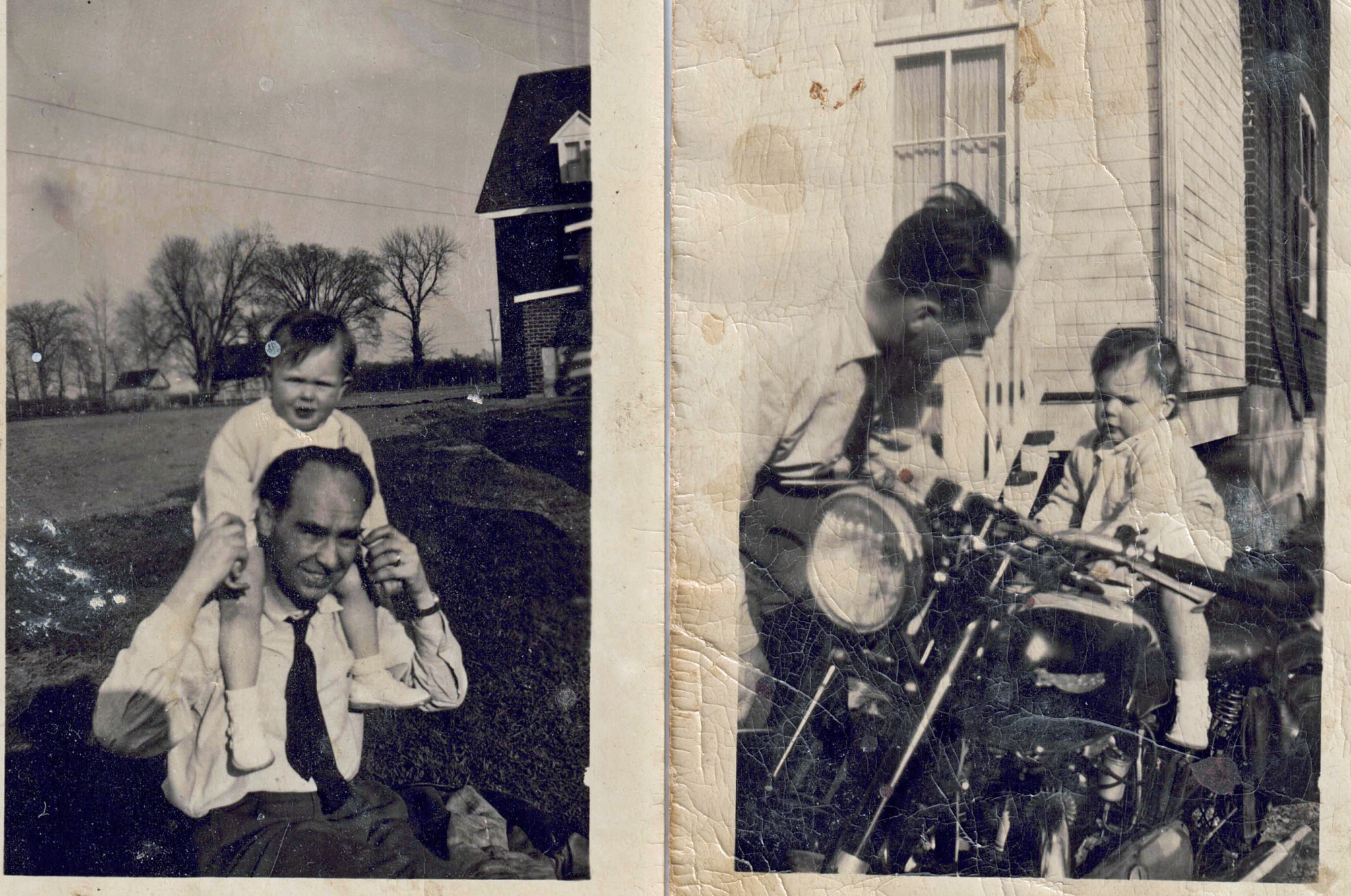
My dad, Stefan, was an aeronautical engineer at Canadair. He drove his Triumph motorcycle to work every day. I would love to attach a photo of my dad, me, and the motorcycle at the Buggy House on Bois Franc but I haven’t had any success at that.
Stefanie
Wonderful to read your message Stefanie! Thank you as well for sending me the photo on Aug. 15, 2022. I will try to upload it soon. I’m working on a journal article which has a tight deadline for which reason I cannot upload it at once. In the meantime, the renowned Graeme Decarie has shared the following messages.
By way of a preface to comments from him: Hi Graeme! Comments from the awesome Dr. Decarie continue to draw readers to my Preserved Stories website. The power of memories from years ago! Here are additional comments in our continuing Bois Franc narrative.
Graeme Decarie (Aug. 14, 2022):
I REMEMBER IT AND REALLY.iL IVE IN THE MEMBERS OF IT. aM I A RELIC. aLAS I’M NOT EVEN THAT.
GRAEME
Graeme Decarie (Aug. 14, 2022):
aND I AM A WRECK OF THE PAST.
Jaan Pill (Aug. 15, 2022):
You are the MAN OF THE HOUR. What you share with your many followers is significant!
As well, the renowned Bob Carswell has noted (Aug. 16, 2022):
Details for Stefanie Brochocki:
You might remember the Pitfield name and its connection to the Macdougall family or ultimately the Ogilvie families of Saraguay which also included Dorothy Molson. They were all interlinked and wealthy. Michael Pitfield was a good friend of Pierre Elliot Trudeau and I used to deliver their morning Gazette. I met him at one point on his front steps. He became a Senator in Ottawa before his death. The entire family connection can be had by looking him up on Wikipedia.
Old Bois Franc Road connected to Pitfield Blvd., which became Hwy 13 eventually. Keep in mind that the French way of farming was a field wide and one field followed the next in a single row from Bois Franc right down to the river at one point. Eventually, the railroad would affect that. So, that probably meant 30 or 40 farms side by side on the north side of Bois Franc, each one field wide and numerous fields long. You might try to find an old telephone book and look up the Montreal family names that you mentioned as they had to be in there somewhere from 1950 to 53. That would help you locate the address. It would have been one of thirty farmhouses or more and most had horses or tractors to do the work.
The hydro station was there in the 1950s and was built about the time you were born. To access it, the work vehicles came up Green Lane in Saraguay and crossed the tracks. Today, the only sign of that railway crossing is a tree planted in the area and a continuous fence. In the 1950s two workmen were killed at the crossing in a collision with a train. Harry Boshouwers was also killed along with the taxi driver at the same crossing in the 1960s coming home from university. This is the same hydro station that exists on the same spot to this day but is no longer accessible from Saraguay. The Therrien brothers, Michael and Philip who lived next to Harry Boshouwers, joined the American Army. Michael is buried in Georgia and Philip became a Montreal policeman before his death spending 30 years with them on return from Vietnam and the war. Unlike the boys who died young, their mother remarried moved to London, Ontario, and lived to be 103 years old. My older brother, me and Michael were three of the 22,000 so-called Canadian War Babies born in England to Canadian soldiers fighting in the war. While Harry Boshouwers’ father was building his place for the family, he needed a hernia operation and came to recover at our house so we always had a connection to the family in that regard. On retirement from Canadair, the Boshouwers moved to Kelowna BC.
The runway you talk about was extended in the late 1950s as the CF-104 jets that were being manufactured at Canadair needed a long runway. Two hundred CF-104 jets were built by Canadair and the first flight occurred in May 1961. The runway line went directly over our house in Saraguay and the noise was relentless during the day but did not last long each time with the speed the jets travelled. I can still hear them going over in my head and that was more than 60 years ago.
Dr. Bergeron was also our family vet and I remember the day we took Pedro our first dog into his office. I sat in the car and watched as my mother came out of his office with tears in her eyes. Unfortunately, there was nothing that could be done for him and he was just too old for any hope of recovery.
I am sure if you make a copy of your photo and email it to Jaan, He would be able to add it to the page.
Here are the photos (click on them for closer view) that I refer to above.
Bois Franc, early 1950s
Stephanie Brochocki writes (Aug. 14, 2022): “Despite my young age (1-2) at the time, I have very fond memories of Bois Franc. Here are two photos. Unfortunately it shows very little of the dear old house, but you can catch a glimpse of Bois Franc in the background.”
My family and I used Chemin Bois Franc regularly. It was the bus route to school (Elmgrove and MCHS) for my brother and me during the 60s. We lived on Toupin.
There was still then a wooded area south of the tracks and a bit west of Toupin. The remnants of Bois Franc?
I still have the Central Vermont Railway oil can that was used to lubricate steam engines. Found it along the tracks walking home from Val Royal Station.
It’s really interesting to read your comment, Gerry, and to re-read comments from years ago, which people have shared.
I’ve also found it of much interest to be reminded of the maps we have at this post (which can be enlarged by clicking on them). The maps are really helpful, in my case, because I do not remember much about the local geography of Cartierville (where I lived) and nearby neighbourhoods.
It’s of tremendous value that people who’ve visited the post have great memories in relation to such details, and have also been able to locate some archival map resources. We owe them many thanks!
With regard to steam engines, part of the history of Stratford, where I now live, is that when the huge facility, where steam engines used to be repaired, closed in Stratford at some point during the postwar years, people began to think of ways to keep the city vibrant. Thanks to Tom Patterson, a dreamer and a visionary, turning to theatrical entertainment turned out to be the city’s way forward. Here’s a link about the history of deindustrialization in this part of Ontario:
Deindustrialization has evoked diverse responses – as in Stratford, Ontario
The reference to the ‘bois’ in Bois Franc brings to mind a story about the saving of Bois-de-Saraguay.
On Sept. 2, 2021, we met for a high school picnic at an apartment parking lot with a great view of Lake Ontario. We learned how Bois-de-Saraguay in Montreal was saved from destruction.
In Saraguay as in Stratford, it was a process of community self-organizing that saved the day. As in the story accessible at the above-noted link, similar processes were at play starting in the 1910s in Stratford:
Stratford, Ontario: Canada’s cultural tourism destination
Mr. Decarie, the few things I remember were the Canadair buildings on one side and the Jet Tavern where Peter M. and me would visit regularly. Sorry, that’s all I got.
When one thinks of the historical aspect of a place like Montreal, one has to keep in mind that all of the lands that made up what is now “Bois de Saraguay” were once totally covered by trees. The same applies to the area of “Bois Franc”, which when you translate the name of the street into English means “hardwood”. The road that was put through was most likely named in the 1700s as the road that was cut through the hardwood forest so that the early sawmills would have a source of trees to turn into lumber to build the houses in the growing city of Montreal.
With hardwood trees so close to the early town, there was no need to go further north to the Laurentians in search of wood for building. Back then there were no bridges across the Rivière des Prairies (named after the “Prairies” family back in the early days of naming farms like “Decarie”, rivers, and so on).
Names evolve over time and often have a reference to a town, village, family, profession, etc. You will often see a name of a person ending in “ton” for example. That name was drawn from the name of a “town” somewhere in the UK. A surname recorded in the town of Harring would translate into “Harring Town” which would eventually have become “Harrington”.
My name is “Carswell” which can be broken down into CAR’s WELL which in addition to a clan name was also a place name located by the source of water closest to where the CAR family lived. The original name “well” meant the spot by the water where people went to draw water. Over time as the water source became a well dug into the ground and lined with stone to maintain the shape of the well, the same word applied, meaning “source of water”. In more modern times it was expanded in use to include, oil wells, and gas well applications.
The name CAR comes from one of the four spellings of the KERR clan as branches moved across the Borders region between Scotland in the north and England in the south. Those four spellings were KERR, KER, CARR, and CAR, and were always the scribe’s spelling of a verbal name given to them. I recently saw the name “McWaters” which identifies three generations of a family. (1) “Mc” which means “son of”, (2) “Waters” meaning the son of Water, and (3) the grandfather who was named “Water”, so basically, we are talking in this one modern-day surname, about the son of the son of a guy named Water.
This surname also implies a location of where the original fellow name Water lived. It most likely had begun as a reference to “John”, whom we will use as an example, who lived by the “water” much like “Car who lived by the well”. So, maybe there is the fourth generation since it was first recorded by the village church minister perhaps as a result of the lad’s wedding. This lad, again let’s call him John, likely lived by the water, and needed to be identified as such to distinguish him from another John living in the same village.
Among the most common names is that of Smith…why? Because every village had a blacksmith, large cities had goldsmiths, coppersmiths, silversmiths, etc. in addition to a local blacksmith of which there was probably one on every street in the city, so the name Smith was very common as a surname and as families were generally very large back then, the name became very common as a surname down through the generations. The first recording of a name is often the creation of that surname and would have usually occurred when the churches began to keep records of their parishioners. You have to keep in mind that there was a day when no surnames existed, just the first name and the majority of people in a small village never left the village throughout their entire lives.
The “Borders” region was the no man’s land of the feudal knights. When “Robert the Bruce”, otherwise known as “King Robert I”, was king of Scotland from 1306 to 1329 he went to war against the English to gain their independence as a nation. Fighting was the lifeblood of many people in those days and one slash of a sharp sword could quickly kill you. It was a brutal way of living and dying. Also, keep in mind that both Ireland and Scotland were once connected to the rest of Europe until a major landslide in Norway sent tons of water into the lowlands like a tsunami and cut the island of today off from the tip of Europe likely killing tens of thousands who lived in small villages in the lowlands in the process. This happened probably about 10,000 years ago, or more.
We all have stories of who we are if we do enough research. Fortunately, it has been a hobby of mine since 1974 so I have been at it for almost 50 years. Depending on the accent of the Scottish fellow who gave the verbal details and the scribe who created the spelling of the first surname, we all got one. Over time, though those surnames even continued to change in the records until finally there became one common spelling for most. Of my own name, there are people out there with the surnames of Kerswell, Caswell, Carsewell, and other similar names that could have originated from the original verbalization of the name as Carswell.
Going back to the days of Bois Franc, the road into the forest eventually produced a field full of stumps. Early people removed the stumps, one by one until they had created fields that they could farm. Because Quebec was mainly French-Canadian in the 16th and 17th centuries, the establishment of farms followed the traditional French way of doing things. Hence, the long narrow fields are attached in a row, one following the other in a straight line.
The King of Scotland in the early 1600s became the next in line to become the King of England so the 300 years of Border Reiving ended, but not without difficulties. There were a number of hangings and that made it necessary for some individuals to move to other countries to stop the British from hunting them down. A perfect example is “Billy the Kid” in the USA, no doubt the descendant of an Irish Catholic whose ancestors probably escaped the Borders of Scotland in the 1600s to get away from their own capture. In later generations, he ended up in New York City but saw himself as an outlaw in the west of the USA and as I have found through my genetic testing is one of my genetic connections. It all makes good sense, where we cannot find definitive proof from written records.
Going back to Robert the Bruce, he began the process of going into England, attacking the British army, and then fleeing north back to Scotland. Along the way, his knights of which the Kerrs were among the mightiest fighters, acquired (stole) all the grain, and herds of cattle on the trip home and drove them into the many hidden canyons of the Borders where they would never be found.
By doing that, the British army would not be able to buy meat from the farmers along the way and would therefore not have food for its soldiers who would then give up the chase and return to London. It was a good tactical ploy that worked well for the invaders from the north and brought considerable wealth to them over time. As the larder got bare, it was time to make another forage into England and steal from the British. It was a way of life for about a dozen generations or more.
It was the ancestors of these individuals who caused the Romans to build Hadrian’s wall during the occupation of England and a second wall further north. We are talking about 2,100 years ago. In the same way that early cave drawings of flying saucers indicate that UFOs have been around for thousands of years. It simply tells us that our Earth is a very young planet, and probably many thousands of years behind alien-inhabited planets in development. We have learned a lot about UFOs and outer space in my life as we have watched to Wright Brothers’ invention in early 1900 grow into what it is today. I am only sad about not being able to be around to see what future generations achieve. Then again, my great-great-great-grandfather never saw the automobile. Life is a journey for each of us.
Hello,
Would anyone have very old maps of Ville Saint-Laurent – I’m talking 1700-1800’s?
Here’s why…my 7 x great grandfather Henri/Henry Girouard married to Marie-Josephte Cousineau apparently lived on Cote-Vertu over looking Rue Principale in Ville Saint-Laurent (1758-1800’s) which later became Boul. St-Croix.
I discovered this while searching for info on Henri Girouard – the following confirms where Henri and Marie-Josephte lived as a Dr. Francois Zepherin Tassé an early Mayor of VSTL lived where Henri Girouard’s house was originally built.
There are 4 corners on Cote-Vertu and St-Croix…The Grou homestead (Chandelier Restaurant and now a Daycare) is on Cote-Vertu near Montpellier (North East side of Cote-Vertu.
Here is the text in french…written after 1850’s
Le 12 juin 1758 il epousa à St-Laurent, près Montréal, Marie-Josephte Cousineau, fille mineure (19 ans) de Catherine Hay, veuve de J. Bte Couisneau de St. Laurent.
A dater de son mariage, il demeura en la Cote de Vertu, près du village de St-Laurent, dans une maison en pierres faisant face à la grande rue du village, précisément à l’endroit aujourd’hui occupé par le Dr. Tassé
Any insights would be wonderfully appreciated.
Many thanks,
Kelly St-Denis
Hello Kelly, interesting question! I will post your question as a separate blog post, so that it will circulate widely. I will also contact a few people I know who may know how to search for the maps that you have in mind.
Many thanks Jaan, much appreciated.
Interesting eh?
Interesting for sure, Kelly. It is thanks to many people that we are accumulating information (that I would never have known about, in my case) about Ville Saint-Laurent.
I saw and read this thread for the first time today, after being alerted to it by a new thread from Jaan.
On December 7, 2014, Janet Stockton Barnes (Marty’s sister?) mentioned David and Paul Price, but neglected to mention the middle brother, Greg, a great friend of mine for many years. Greg was my age. I think David was seven years older and Paul was two years younger. Julius Simon (another classmate) and I often went to Greg’s house to play basketball or cards with Greg and Paul, since they had a basketball net attached to the side of their house. All three brothers, as well as their parents, were great people.
On December 18, 2014, Tim Hewlings mentioned that the “fish market” was Gidney’s, which I can confirm. My mother worked there as a bookkeeper for several years.
One of the many great things about “Preserved Stories” is the way it rekindles old memories. Kudos to Jaan!
Wonderful to read your message Bert!
I’m really pleased that this post about Bois Franc (among other posts about other topics) has given rise to the extensive sharing of information about days gone by. Your comments, Bert, and those of other site visitors add immeasurably to the quality and scope of the great memory-related work we are all doing together.
Best,
Jaan
Hello, cannot believe I just found this discussion I can add some info. My grandfather William Duncan Forbes worked for Pitfields in the 30’s and 40’s as his manager? of cattle. My father and his siblings grew up in a house provided by the Pitfield farm at 405 Bois Franc Road. We understood it to be on the farm.
My dad grew up as the cattleman’s son alongside Michael Pitfield that someone wrote of in earlier comments. I understand that the roads have changed very much since then but I wonder if someone could tell me what the walking distance would have been from 405 Bois Franc Rd. to Cartierville School?
When my father joined RCAF 1942 he was living there (with his family) and his father was still working for Pitfields. Tks
Hello, I will check among my contacts to see if we can find the answer to your interesting question. I had forgotten about this discussion – thank you for reminding me of it! So many interesting comments from so many people.
I’ve followed up with a separate post; I used Google Maps to find the answer to your question, Rhonda:
Interesting question: How long would it take to walk from 405 Bois Franc Road to Cartierville School?