Ville St-Laurent, Quebec: Wartime housing and architectural change, 1942-92: Article by Annmarie Adams & Pieter Sijpkes (1994)
A previous post is entitled:
Click here for previous posts about Ville St-Laurent >
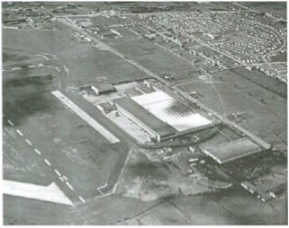
Aerial view of Ville St-Laurent. Source: “Wartime housing and architectural change, 1942-92” by Annmarie Adams & Pieter Sijpkes (1994)
Click on the maps (below) to enlarge them
In researching the topic of postwar emergency housing in Toronto, I recently came across a 1994 article, published by McGill University, about postwar housing in Ville St-Laurent, on the Island of Montreal.
The study is from Ethnologies: Vernacular Architecture, 17-2, 1995.
The history of Ville St-Laurent is of interest to me because I grew up in the 1950s in Cartierville, which is next to Ville St-Laurent.
The article, by Annmarie Adams and Pieter Sijpkes, is entitled: “Wartime housing and architectural change, 1942-92.”
Wartime Housing and Architectural Change, 1942-92 (1994)
The opening paragraphs (I have omitted the footnotes) read:
![Typical street scene in Ville St-Laurent today, photograph A. Adams. Source: [Ville St-Laurent, Quebec:]](http://preservedstories.com/wp-content/uploads/2017/02/Untitled.jpg)
Typical street scene in Ville St-Laurent today, photograph A. Adams. Source: [Ville St-Laurent, Quebec:] “Wartime housing and architectural change, 1942-92” by Annmarie Adams & Pieter Sijpkes (1994)
A closer look, however, reveals Ville St-Laurent’s wartime, rather than postwar, development. Belying the various setbacks, building materials, roof configurations, and changing scales of the house of Ville St-Laurent are 400 nearly identical houses, constructed as modest, temporary dwellings for factory workers during World War II. The original inhabitants of these tiny houses worked not in Montreal, but in the nearby Canadair factory, which produced Catalina warplanes for the Allied Forces. Few of the early inhabitants owned cars.
The first residents of Ville St-Laurent, in fact, describe their neighbourhood as “out in the boondocks,” “in the middle of nowhere,” and “resembling an army camp.” Narrow roads without sidewalks were largely defined by the ditches which ran alongside them. There were no trees. Makeshift bridges shared between two families provided access to each house. “The project,” as residents still call it, was nicknamed “Mudville.”
I’ve uploaded three of the maps from the article. For a close view of the maps, your best option is to go the onlinePDF of the article, where you can zoom in on each of them.
[End]
Three brothers named Descaries
The article suggests that “architectural change is tied closely to changes in family size and structure, the availability of credit, and evolving trends in the use of building materials.”
The article suggests that “architectural change is tied closely to changes in family size and structure, the availability of credit, and evolving trends in the use of building materials.”
I found it of interest, through reading the article, to learn something new about the history of St-Laurent.
Among other things, I found the following details (Page 1, note 2) made for informative reading:
“Ville St-Laurent was originally settled by three brothers named Descaries in the late seventeenth century. For a general history of the area, see Rumilly, Robert, 1970. Histoire de Saint-Laurent, Montreal. The city early doubled its size during World War II; see Snyder. B.J. Jr., 1950. Marked Expansion in Industrial and Residential Saint-Laurcnt, The Monitor, 21 September.”
Reinhabitation of the house through narrative
The Oxford Dictionary defines reinhabitation as: The action or an instance of reinhabiting a place.
I was interested to learn of the research methodology that Adams and Pieter Sijpkes have adopted.
“Our study offers no typology of architectural change; at least three other studies of wartime housing in Canada have fulfilled that objective. We focus, rather, on a smaller sample (25 case studies) in much more depth and employ methods more commonly used in the fields of anthropology, cultural geography, and folklore than in traditional architectural research. Instead of focusing on formal analysis, that is, this project assumes architecture as a dynamic process and grants building users agency in the shaping of their own spaces. Architecture as imagined or constructed by its designers is only a starting point for such analyses.
“Folklorist Michael Ann Williams has described this methodology (particularly the use of oral testimony) in the study of domestic space as a ‘reinhabitation of the house through narrative’ and has suggested that the richnessof this case study approach may call into question the usefulness of studying buildings as artifacts. Following this thinking, we hope our research contributes to a growing understanding of the do-it-yourself home improvement industry in Canada, and, more generally, to the study of vernacular architecture.”
Shelter for Victims of Environmental Disasters (1991)
I was pleased to learn that Annmarie Adams and Pieter Sijpkes are contributors to a study entitled: Shelter for Victims of Environmental Disasters: Charrette, École d’architecture de l’université McGill, 25 & 26 février 1991 = McGill School of Architecture, February 25 & 26 1991.
Click here for additional studies by Annmarie Adams >
Wartime Housing Limited, 1941-1947: Canadian Housing Policy at the Crossroads (1986)
A 1986 Urban History Review article by Jill Wade, entitled: “Wartime Housing Limited, 1941-1947: Canadian Housing Policy at the Crossroads,” is of related interest.
The article’s concluding paragraph reads:
In 1944-1945, the Canadian government had the opportunity of implementing the Curtis report’s major recommendation – a comprehensive, planned national housing program emphasizing low income accommodation. When it created CMHC, the government could as easily have channelled WHL’s expertise into the constitution of a national low-rental housing agency. A single federal authority could have administered and co-ordinated both agencies and initiated a comprehensive nation-wide housing plan. Instead, the government disregarded the Curtis report’s suggestion and maintained its pre-war commitment to private enterprise and home ownership. In retrospect, federal affirmation of the “market welfare” approach has restricted state activity in public and social housing and precluded the introduction of a national housing plan for forty years. Only a shift in attitude fully recognizing the social need for housing will bring about any significant change in federal policy.
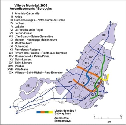
Figure 1: City of Montréal, 2006, Boroughs (Arrondissements). Source: The Spatial Patterning of Wealth and Poverty in the Montréal Region, 1971–2006: A Literature Review (October 2013)
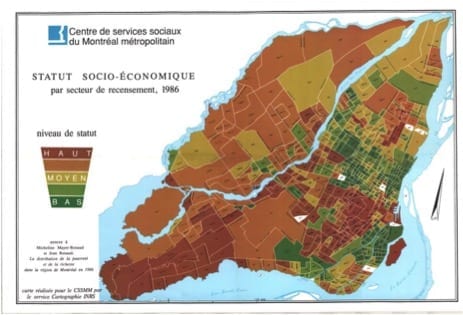
Figure 8: Socio-Economic Status by Census Tract, 1986
This map shows the socio-economic status of census tracts in 1986. Red: High-status; Orange: Medium-high status; Olive: Medium status; Light green: Medium-low status; Dark green: Low status. Source: Source: The Spatial Patterning of Wealth and Poverty in the Montréal Region, 1971–2006: A Literature Review (October 2013)

Figure 9: Socio-Economic Status Index – Montréal Metropolitan Region, 1991
This map shows the socio-economic status of census tracts in 1991. Red = High; Orange = Medium-high; Yellow = Medium; Light green = Medium-low; Dark green = Low. Source: The Spatial Patterning of Wealth and Poverty in the Montréal Region, 1971–2006: A Literature Review (October 2013)
[End]
Spatial Patterning of Wealth and Poverty in the Montréal Region, 1971–2006 (2013)
In a previous post, on a related topic Graeme Decarie has remarked that many changes have taken place in Cartierville where Malcolm Campbell High School is located:
Regarding this topic, an October 2013 research paper, “The Spatial Patterning of Wealth and Poverty in the Montréal Region, 1971–2006: A Literature Review,” by Amy Twigge-Molecey at the Cities Centre, University of Toronto, is of interest.
The article categorizes neighbourhoods (for purposes of data visualization) into the following categories by socio-economic status:
Red: High-status; Orange: Medium-high status; Olive: Medium status; Light green: Medium-low status; Dark green: Low status.
It also tells you were the hotspots of gentrification have been making their presence known, and the locations where poverty has taken root with particular tenacity.
To get a closer view of the three maps, that I have posted, from the research paper, a good option is to access the online PDF of the article, where you can zoom in on each of them.
Reinhabitation (or re-inhabitation) and storytelling
A subsequent post is entitled:
The Three Cities Within Toronto (2010)
Similar studies are available for other Canadian cities. Among them is a 2010 study entitled: The Three Cities Within Toronto: Income Polarization Among Toronto’s Neighbourhoods, 1970-2005.

Source: The Three Cities Within Toronto: Income Polarization Among Toronto’s Neighbourhoods, 1970-2005 (2010)
Links to additional studies are available at the Neighbourhood Change website at http://neighbourhoodchange.ca
Website with details about St-Laurent and Norgate Shopping Centre
From the Montreal Memories Facebook Page, I’ve found this great link, from http://www2.ville.montreal.qc.ca :
Click here to access a Canadian Encyclopedia reference to Norgate Shopping Centre >
Leave a Reply
Want to join the discussion?Feel free to contribute!
My father Curtis Ingerville was interviewed and quoted in the unabridged article. The publication also included a photo of our house and my parents.
That is most remarkable, Nancy! Do you know where I can find the unabridged article?
I came across the online version of the article when I was reading about postwar housing in the Toronto area. My online searches led me to the article about Ville St-Laurent, entirely by coincidence. As it happened, I had written several posts in the past about Ville St-Laurent, for which reason I was absolutely fascinated to read the 1994 article. I said to myself, “This is so interesting. What a find!”
Talk about coincidences. I would never have guessed that you have such a close connection to the article by Annmarie Adams and Pieter Sijpkes. Your father was among the people interviewed!
The coincidences continue: It was a delight to meet you at the MCHS 2015 Reunion. Your help in the organizing and staging of the event added so much to the level of enjoyment that all of us experienced, at the Reunion!
With regard to another topic, namely the variances and consistencies over time in patterns of income levels, a Jan. 12, 2017 Science of Us article is entitled: “Why Scandinavians Care More Than Americans About Inequality.”
The opening paragraphs read:
Scandinavia is held up by American lefties as a socialist alternate reality — look at how good statecraft could be! It’s a fantasy that gains urgency when you’re reminded that one-percenters take home 18 to 19 percent of all the income in the U.S., compared with taking in 5 to 8 percent in Scandinavian countries.
Given that gap, you have to wonder why — save for an Occupy Wall Street or two — Americans are so comparatively chill about inequality. It’s a question that a team of researchers at Norwegian School of Economics — Ingvild Almås, Alexander Cappelen, and Bertil Tungodden — recently sought to answer in a cleverly designed discussion paper, highlighted by Alana Semuels at The Atlantic. The research team came to a startling and illuminating conclusion: Maybe Americans and Scandis frame fairness differently, and maybe that’s part of why the two societies are set up so differently.
[End]
I’m late in replying to this because life has been very busy for me. However, the name Decarie has many, many spellings – Descarie, Descary, and on and on. That happens with varying literacy over the years. To make it even more complicated, the name is originally Spanish – that language has its own variations on it.
In high school, I was called Dickory. A teacher once said to me in class, “Dickory, stop Docking.”
I wasn’t aware of the Spanish connection! Good to know you are keeping busy. It’s what keeps us young and active!
You have me thinking about my youth and wartime housing so here are a few comments about what I know about “Mudville” and other facilities around Canadair in the late 1940s, early 1950s and early 1960s when I went to MCHS. First let me talk about my earliest days after I learned to walk on my on. In the 1940s, probably 1949 when I was almost 5 years old that summer, my older brother who was age 6 at the time and I were basically given free rein to roam. Back in those days, you did not worry about kids being kidnapped or misled, you left your house and car unlocked and did not expect anyone to break in. Perhaps letting us roam was a bit naïve of my mother but she had just arrived from England in 1945 and a lot of things were strange to her. Nevertheless, we loved it. We would roam far and wide and get into all sorts of trouble my mother never heard about. We climbed the beams in barns, went for long walks that could have got us lost, set fire to a lumber yard by accident when we took matches away from the younger kids who were playing with them. We thought it would be best to light them all and then make sure they were out for good. Little did we know that doing it in the lumber yard behind our house was dangerous. After all, we could not do it at home.
My mother had her hands full by the summer of 1949.
We were four children under the age of five and the younger two needed more guidance than the older two so we got to spend the summer days on our own. Walter Jim and I were inseparable. While we went to the Anglican Church, Walter went to the Pentecostal church. My parents exposed us to a lot of things along the way, and going once to a Pentecostal meeting with Walter’s family, going to a Pentecostal summer camp on the west side of the Lake of Two Mountains where I was kicked by a pony, were all part of our youthful life experiences. At one point I also went to a Bar Mitzvah to experience that as well.
Today there is a family on a Dairy Farm in Howick, Quebec who still remember the story about the kid who climbs the old barn in the late forties following his brother Jim and neighbours’ son, Walter McDevitt who our mother sort of looked after, after school until his parents got home from work. I was the kid that fell into the hay pile and disappeared.While the other two boys were out looking for help, I was pulling hay out of the walls of the well I seemed to be in because I was able to see the light at the top of the hole and I wanted to get there. I kept filling the space below me and stepping on the hay until I could lift my head over the top and see out, just as the farmer, who was way out in the back fields and French florists from the next door nursery arrived to help. (If you are interested in learning more about the Cartierville farm and the Tolhurst family, see http://www.tolhurstfarms.com/us for more details.
There is also a photo of the grandfather at the Cartierville farm which had been there for a century before the family moved on. The building out back in that photograph is the old barn where I fell into the hay. It seemed a lot bigger when you were 4 years old. In their story page about the family they also make reference to their Cartierville roots even though they left the area as I did almost 70 years ago.)
We moved to Saraguay around 1951 and I specifically remember my teenaged years at MCHS going to two restaurants quite regularly. The first was at the corner of Dudemaine and O’Brien on the NE corner which we would walk to sometimes at lunchtime to buy snacks. The second was just across the tracks south on O’Brien on the west side, literally right by the tracks. The students used to takeover the basement of the new building for dancing after school for about an hour waiting for the Roxboro train that came through about 4:15 p.m. It was not my train. Going home from there I often walked south to Bois Franc Road and then west over to Grenet Street where the No.17 streetcar line to Carterville ran. I did not know that the wartime housing on the south side that took up the entire block between O’Brien and Grenet St on the south side (which I never walked through) was called Mudville by the locals from its early days.
I travelled a lot throughout Cartierville and St. Laurent with my brother from a very young age and as a teenager, especially when we were living just down the road from Val Royal train station in a 6-plex (3 & 3 side by side) near de Salaberry Boulevard. We often went up to climb over the old train engines stored just west of Val Royal until the railroad police once chased us away. Then we had to be content to watch the old square-boxed electric train engines that pulled the local commuter trains to Val Royal and Cartierville. The trains to Roxboro needed diesel engines. During that time the whole block called Mudville always eluded me.
There was a very old store/restaurant right there at the crossing on the NE corner of Grenet and Bois Franc Road which also catered to traffic from the Val Royal train station that departed on the South side of the station. I am guessing it had been there doing that as long as the train ran through the tunnel and out to Lake of Two Mountains which I guess goes back to the 1800s. (It is sort of like the businesses that were on Ranger Street in Cartierville when we were kids and the restaurant/store that was the stop for the Laval bus system on Ranger Street in Cartierville when it met the No. 17 streetcar ever since the first line was put through to Cartierville probably back around the early 1900s. They all depended on the pedestrian traffic that the streetcars or later, the buses. brought there for them to stay in business. When I went to the evening high school, three of us became good friend, one a good looking Jewish girl that neither of us had a chance with, Dietmar Drieze who lived in Laval and was quite a skier, but who was involved with two car accidents in St. Sauveur and broke his jaw twice in successive winters. He had to have it wired shut for about two years while drinking liquid to get the food in.
We took the streetcar home from SGWEHS and I waited with him until the Laval bus came before hitchhiking out to Saraguay. On the last night we were in classes, as we all graduated together, the girl suggested that we go across to a bar on Cote des Neiges downtown and catch a show. It turned out to be Stompin’ Tom Connors who provided the entertainment. That would be back in 1965. Since then Dietmar has gone from being a purchasing agent in the construction company in Montreal to become the President of the company and now lives in Hudson, last I heard. We lost touch decades ago. I am guessing he has retired by now.
If you look at google maps today you will see that that same corner has really changed now with tall 4 story apartment buildings on stilts so cars can park below and widened to go under the new rail bridge at Val Royal. When I travelled under the bridge to the other side, the apartment building we first moved into in Cartierville on Ranger Street where it meets Grenet had not changed.
We lived moved in there when we first got married in 1970 and it is still the same. We were there for two years before moving to Toronto but everything south of there has really changed including Henri Bourassa Boulevard which now replaces the old two-lane Bois Franc Road. However if you go east on it from Grenet to the first street going south, you are right there in the old Mudtown, which has changed very little from when it was first built during WWII for families who worked at Canadair. On the old Laurentian Blvd where Canadair is situated, there were three white two story shed-type buildings with white front staircases to the second floor. These were initially designed to be bachelor accommodations for single people working at Canadair. They all had shared facilities and each front entrance on two levels ran all the way to the back of the buildings where the back stairs were located. I recall them being very long buildings probably able to accommodate 30 people per floor or more in a single room accommodations.
I was given the opportunity to go inside them when my mother hired a cleaning woman named Mrs. Hanson. Her husband was in jail at the time and she was raising 3 kids on her own in a two roomed single’s pad. She may have had two rooms by then as they were no longer used for Canadair employees after the war. This would be in the early 1950s as her kids were all teens at that point. After Canadair no longer needed it for its people I suppose they rented the units out for the less fortunate for those who could not afford a better place to live. I always remember it being full of mothers and kids. In time, when things improved for the parents and the kids had grownup and gone on their own, the Hansons moved to Cartierville into a small new apartment building on Legault Street, the short side street at the top of Ranger Street which the old streetcar use to use to get back to the Grenet Street tracks after leaving the Cartierville terminal and going along Ranger Street. My mother would drive to Cartierville every two weeks for something like the next 25 years to pick up Mrs. Hansen to do housecleaning until she was too old to do it anymore. In many respects you could say she was an old English grandmother who came to visit us kids. Always a lovely person.
We only knew our Gran Gran, my grandfather’s second wife who raised my mother as a teen after her own mother died when she was about five. Until then she had been with her grandmother and her large family. Her grandfather was the Finnish-Swede in our family who had left Finland at the age of eight, gone to sea for 20 years and got off the boats in London, England, at age 28, a qualified ship’s carpenter. I always said of him, “a Swede by race, a Finn by location, a Russian by occupation and a Brit by choice.” He lived in England for the next 60 years through two wars in London. Not the best place to be. If I live another 16 years I will be his age when he died.
On a different topic, did you know that the Norgate Shopping Center was the very first strip mall built in Canada. I remember going through it each day when I attended the Northmount YMCA summer camp events at their facility just north of it, I reached it through the open covered walkway between the two buildings that make up the mall shops. It was built in 1949 so that makes it 69 years old and still going strong, owned by the original family who first financed it. My favourite place as a teenager was the donut shop that used to be across the street. An older neighbour of our was driving at 16 so we made regular Friday night trips to taste these new delicacies. What else do growing boys with a sweet tooth like me do at age 14?
Hello Bob. I have just finished reading your story. My goodness, I could have sworn it was my story. Every place you mentioned: Cartierville, St Laurent, war time housing built near Canadair. The 2 white, shed-like buildings is where we lived. Four children and my parents lived in 2 rooms. There was a little store on the first floor which sold practically any food, canned no fresh. We children hung out there in the evening where they played music. My Dad worked at Canadair. Some good memories but more bad ones, until we moved to Jasmin St. in Cartierville.
Hi Marjorie,
I am guessing you moved to Jasmin Street below Gouin Blvd as at that point I do not believe the north side had been developed yet. Did you go to Cartierville School? If so, when did you graduate?
I’ve gone back into your comment and have added a few more paragraph breaks. It’s a great story!
Sometime I may go back and add a few additional paragraph breaks. It’s all for a good cause.