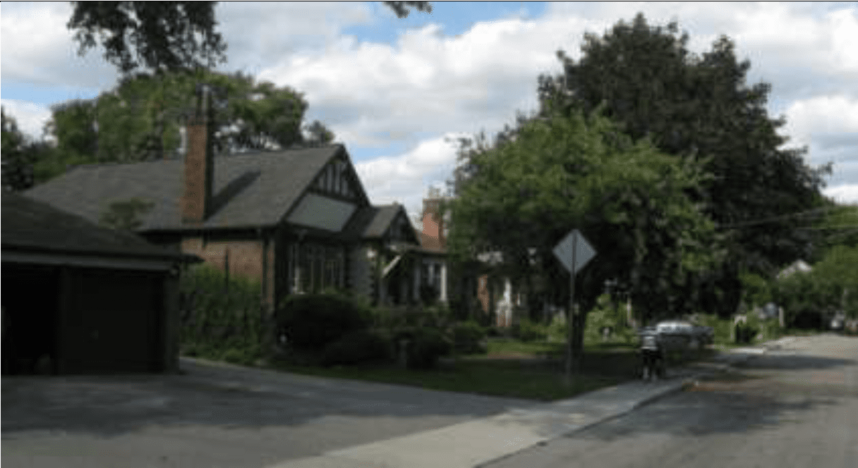
Early 1900s buildings featuring documented strong heritage attributes, such as one at 58 Wheatfield Road in Mimico, are ideal candidates for designation under the Ontario Heritage Act
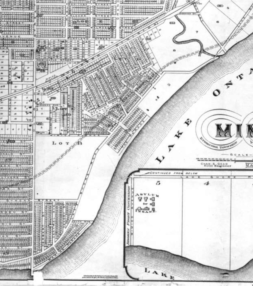
Detail from Charles E. Goad map published in May 1890. Source: Mimico 20/20 Revitalization Cultural Heritage Resource Assessment, page 14
As a former resident of south Etobicoke – we lived in Long Branch for 21 years until July 2018 – I have a keen interest in the history of land-use decision making in Mimico and nearby waterfront communities.
I have learned, based on anecdotal observation and relevant resources, that the culture of land-use planning, in any given neighbourhood in Ontario or elsewhere, generally reflects a local history – and reflects a wider history, within which the local history is embedded.
As well, I’ve learned that cultures of land-use decision making can change dramatically, with the passage of the years, as I have noted at a previous post:
With regard to land-use decision making in Etobicoke, I strongly support a community-based project, which I learned about recently, aimed at designation of 58 Wheatfield Road in Mimico, in south Etobicoke, under the Ontario Heritage Act.
May 25, 2012 Mimico cultural heritage document
A useful background resource, regarding 58 Wheatfield Road, is a May 25, 2012 document entitled: Mimico 20/20 Revitalization Cultural Heritage Resource Assessment prepared by URS Canada for Heritage Preservation Services at the City of Toronto department of planning.
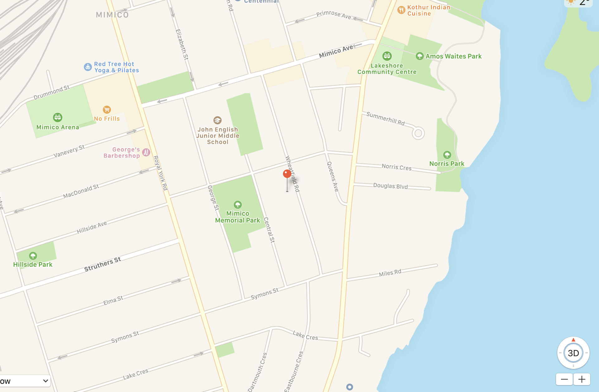
Screenshot from Google Earth indicating location of 58 Wheatfield Road in Mimico
In its study of Mimico history, the document notes (page 1), that “the preservation and incorporation of heritage values into the planning process is considered critical to the overall success of the [Mimico 20/20 Revitalization Action Plan] in maintaining community character and in meeting [the] City’s Planning Policy requirements.”
The purpose of the above-noted study is to “identify and describe the Heritage Character of Mimico, and built elements that contribute to that character” (page 1).
The document succinctly outlines the history of Mimico.
On page 58, the report refers to 13 properties in Zone 2 that are listed on the City of Toronto’s Inventory of Heritage Properties, and were previously listed on the Etobicoke Inventory of Heritage Properties. The properties include 58 Wheatfield Road.
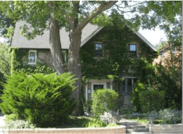
58 Wheatfield Road. Source: Mimico 20/20 Revitalization Cultural Heritage Resource Assessment, page 83
On page 83, details are provided regarding 58 Wheatfield Road; among other things, the document refers to:
- Property Description: Lot 218 Survey Plan no. M134, Mimico, Township of Etobicoke
- Type: Late Victorian form, simplified
- Built ca. 1908 for Alfred Baker
- Description of Resources: L-plan house with a stucco finish, structural material unknown
- Integrity of Design: Appears to be high, although the stucco may be a later alteration
- Heritage Status: Listed
Police Village
I have read about a stage in Mimico’s history when it became a police village. I was wondering what the term meant.
The document explains (page 7) what the term means: “In 1905 Mimico became a Police Village, meaning that it had a Board of Trustees with a limited range of authority on local matters, but remained part of the Township in all other respects.”
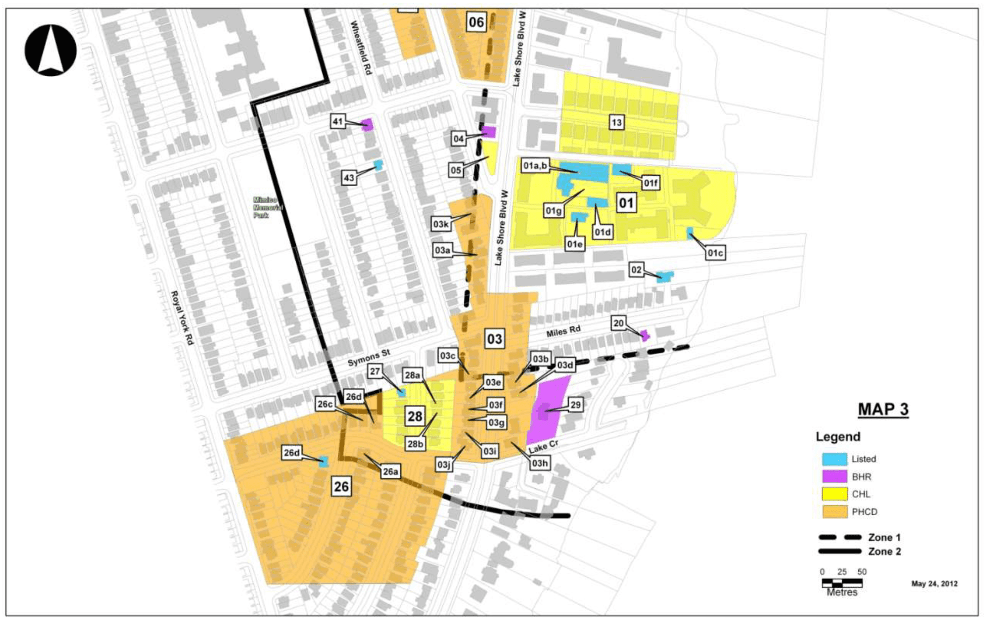
Mimico 20/20 Revitalization Cultural Heritage Resource Assessment includes detailed maps (this one is from page 30) depicting heritage properties.
Another glimpse of history (pages7-8) has drawn my close attention:
“At the onset of the Great War in 1914, industries critical to the war effort moved into the area due to the location of the rail yards. Wartime was a period of rapid growth, including the construction of residential neighbourhoods. The presence of industry stimulated the development of housing for workers, managers and those in the service industries that came with them. The village grew to such a degree that it was incorporated as a town in 1917.”
Great Depression
I have read widely – most recently in Dark Age Ahead (2004) – about the Great Depression that spread worldwide in the 1930s.
The report notes (page 8): “After the economic crash of 1929 there followed a period of economic decline in Mimico and other similar communities whose municipal tax base was primarily residential. The incorporation of New Toronto and shifting of the boundary effectively put the bulk of industrial land outside of Mimico. Development stagnated. [9] In an attempt to reverse the trend, the town put up signs on the approach roads to attract industry and developers, describing the many advantages of locating in Mimico, including the convenience of the railway and streetcar service, the healthy air, and other amenities.”
Note 9 in the text reads:
“9 Esther Heyes. Etobicoke: from Furrow to Borough. (Etobicoke, Ontario: Borough of Etobicoke, 1974), page 159.”
[End]
T. Eaton Company, St. Marys, and Mimico
I was also interested to learn about the connection between Mimico and the T. Eaton Company
St. Marys is a town near Stratford, the city where we have lived since October 2018. As I’ve noted at a previous post, the T. Eaton Company has a close historical connection to St. Marys:
Heritage walks in Stratford and St. Marys are of interest
The Mimico report refers (page 8) to a housing initiative in Mimico connected to the T. Easton Company:
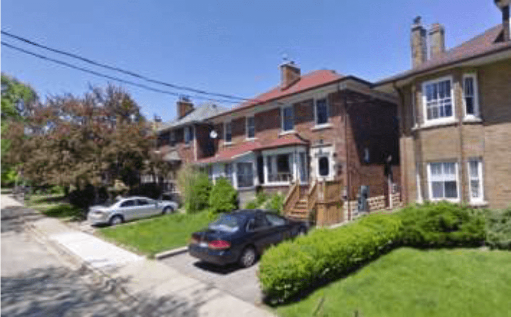
“One philanthropist, Harry McGee, Vice-president at T. Eaton Co., set up a make-work project to stimulate the local economy and attract development in Mimico. In 1931 he contracted R. Herod, a local builder, to build single-family and duplex homes (11 buildings in all, Site 32 CHL) along Stanley and Albert Streets. The initiative provided a much-needed injection of employment opportunity and income.”
Source: Mimico 20/20 Revitalization Cultural Heritage Resource Assessment, page 74
Source: Mimico 20/20 Revitalization Cultural Heritage Resource Assessment, page 74
Details about this feature of Mimico’s heritage resources include (page 74):
- Type: Cultural Heritage Landscape, from 20 Stanley Avenue to 39 Albert Street
- N.B. a sampling of properties only is listed below. The examples given are not comprehensive
- Location: Survey Plan M77
- Heritage Character: The streetscape in this area was developed in the 1930s by Harry McGee, Vice-president at T. Eaton Co., as a make-work project to stimulate the local economy and attract development in Mimico. He contracted R. Herod to build single-family and duplex homes (11 buildings in all) along both streets in 1931 (Advertiser, 3 December 1931). The character of the group clearly expresses the era.
Postwar planning history of Mimico
The document notes (page 9) that:
“Several options for administrative reorganization were considered in the years following the Second World War, eventually resulting in the amalgamation of Mimico and other Lake Shore communities into the Borough of Etobicoke in 1967.

View from parking lot at apartment in New Toronto. The photo was taken on Jan. 25, 2019. A fascinating feature, of the history of land-use planning in southern Etobicoke, is that in some cases the shoreline of Lake Ontario, in this part of Toronto, ended up as parking lots for tenants: Parking lots with a great view of the Toronto skyline. Jaan Pill photo

View of parking lot in New Toronto, from which photo (see above) of Toronto skyline was taken. Jaan Pill photo
“During the same period, most of the large waterfront estates in the study area were subdivided and sold off. The east side of Lake Shore Blvd was built up with a dense collection of anonymous low rise apartment buildings with their backs to the lake, and the shore itself – unbelievably – was given over to parking lots for the tenants. The reason for this is that from 1950-1960, building inspector Jack Book judged it better to encourage construction projects than to enforce zoning requirements. Book bowed to the wishes of the developers, presumably believing that in the long run, the tax base of the town would be stronger. The Judicial Inquiry, carried out by Judge Shea, concluded that:
“It started with small by-law violations, sanctioned in the philosophy that Mimico needed building. From these small beginnings the builders, the real estate men and the developers took over. They took complete charge, and, if they were not encouraged, they were certainly not interfered with or impeded, to any appreciable extent, by members of council or officials. [10]
“Mr. Book spent time in prison for perjury, and the developers’ spree was brought to a halt. [11]
Notes
“10 “Mimico Building Chief Rapped by Probe Judge,” Toronto Daily Star, 5 February 1962, pp 1, 4.
“11 I am indebted to Michael Harrison for sharing this information, which clarifies how the east side of Lake Shore Blvd became a planner’s nightmare.”
[End of notes]
Development after 1962
The report notes (p. 9):
“After 1962, the area remained relatively static in terms of development until the last two decades of the 20th century, when higher density condominium blocks began to encroach at the north end.
“The commercial street has undergone superficial modernization and remodeling without significant changes in scale or density.
Vestiges within Zones 1 & 2
The report also refers (p. 9) to Vestiges within Zones 1 & 2:
“The main contributions of the post-war period to the present built character of Mimico are the anonymous low-rise apartment buildings that dominate the east side of Lake Shore Boulevard West. In addition, many retail properties were modernized, resulting in a loss of character.”
Design context
With regard to what it terms the “design context,” the report notes (p. 24), among other things, that:
“There is a remarkable cohesion of style, palette and scale in the residential building stock of Mimico. The historical period of the first two decades of the 20th century dominates the streetscape, with some elements of the late 19th century and later 20th century structures and modernizations. Until the recent introduction of high rise apartment and condominium buildings, the scale of buildings was limited primarily to low rise apartment blocks and single family dwellings, along with single- or two-storey commercial buildings. This resulted in a small-town character that has survived very well until quite recently.”
A subsequent post is entitled:
Leave a Reply
Want to join the discussion?Feel free to contribute!
Not sure if it is that well known that Sir Henry Pellatt spent his last days in the Mimico home of his chauffeur. Money for the building of his fabulous Casa Loma ran out. Pellatt was not only penniless but friendless except for the compassionate chauffeur who offered Pellatt a place to live. The Toronto Star would never run this story because they are too wrapped up with notions of the ALMAGAMATED towns and residents having no history and no importance. Areas with a history far older than Toronto’s.
That’s a most interesting aspect of Sir Henry Pellatt’s life.
I’ve been recently reading about the history of Victorian architecture in London (Ontario) and southwestern Ontario. Among interesting details, associated with all historic houses, are the life stories of the people connected to the financing, design, and construction of the buildings.
Also of interest are the stories attached to the many people who lived at a given heritage building and neighbourhood, over the years.
All such stories are embedded in the larger-scale history – which I also find of much interest – of whichever era, that they lived in.
The book I’ve been reading is entitled: Victorian Architecture in London and Southwestern Ontario: Symbols of Aspiration (1986).
In recent months, I’ve been looking at heritage houses – houses built from around the mid-1800s to the early 1900s in particular – in Stratford. There are many neighbourhoods where a large majority of the houses date from that era, and a good majority of them are in good condition. I’ve been thinking, “As I look at these buildings, as a naive and untutored observer, what is it that I see?”
As a next step, I’ve begun to read about the architectural history associated with such houses, and have begun to learn the vocabulary, that is used when architectural historians speak about the design details, that are associated them.
I will make it a point to read more about Pellatt and his life story.