History of Long Branch (Toronto) – DRAFT 4
*
Long Branch Rifle Ranges, Long Branch Aerodrome, Long Branch Racetrack: What do they have in common?
What the rifle ranges, aerodrome – Canada’s first aerodrome; it was located beside the rifle ranges, in Mississauga – and racetrack have in common, for a start, is a name.

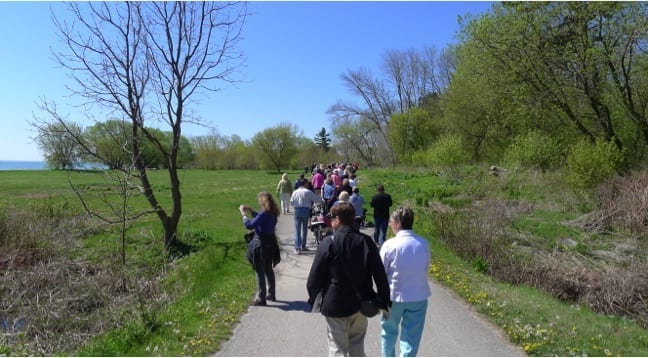
Walking south along Waterfront Trail toward Lake Ontario shoreline, from Small Arms Building, during May 3, 2105 Jane’s Walk led by City of Mississauga Ward 1 Councillor Jim Tovey (second from left, holding coffee mug). Wooden baffles at Long Branch Rifle Ranges are visible in background. Jaan Pill photo
As well, they have in common the fact of life that each of them is long gone.
What they also have in common, aside from the name “Long Branch,” and the fact they are long gone, is that none of them actually had a direct, geographical connection to the historic Village of Long Branch.
The rifle ranges and aerodrome were located in Toronto Township, a community that existed to the west of Long Branch. Toronto Township is now called Mississauga; the rifle ranges and aerodrome were never located inside the boundaries of Long Branch. The racetrack, as well, was actually located north of Long Branch; it too was never located within the borders of the latter community.
Nearby neighbourhoods, we can speculate, appeared to enjoy naming things after Long Branch. Brevity may have been a factor – “Long” and “Branch” is each a single-syllable word. The two words roll off the tongue easily.
The name may also have given rise to visual imagery that appeals to people: One can picture a river; it has two branches; one is the short branch, the other is the long branch, of the river.

Navesink and Shrewsbury Rivers, New Jersey. Source: geographic.org website
As noted below, Long Branch in Toronto may have been named (the evidence is not definitive, on this matter) after Long Branch, a beachside city in New Jersey; the latter Long Branch is named after the “long branch” of an actual river, the Shrewsbury River, a short stream in central New Jersey. A map of the river, on the page you are reading, is from the geographic.org website. Thus it may be that the Long Branch in Toronto may itself also have made a practice of borrowing an evocative, pleasant-sounding name from another location.
If you can share any information, that sheds light on this compelling topic – that is: Why was the name “Long Branch” given to things outside of Long Branch (Toronto)? – please let us know.
[Please note – Feb. 18, 2021: The article you are reading is a draft. What I’ve said above about “Long Branch” being easy to say is just unsubstantiated conjecture on my part. During a Jane’s Walk bike ride a few years after I wrote the draft, I learned from a source that I consider reliable why the name “Long Branch” most likely ended up being attached to locations outside of the boundaries of the Village of Long Branch: There was, the source noted, a “Long Branch” post office in this general area, and for that reason the name was used. I do not have the name of the source at hand as I write this note.]
Introduction
By way of introduction, regarding the story of Long Branch, which is now a part of south Etobicoke in the City of Toronto, below is a summary of key points that we seek to share.
Colonel Samuel Smith
After military service with the Queen’s Rangers in the American Revolutionary War, Colonel Samuel Smith was granted a large tract of land in 1793, which included all of what is now called Long Branch.

John F Kensett, December 1858. View of the Shrewsbury River, New Jersey. Google Art Project.jpg. The image is in the public domain.
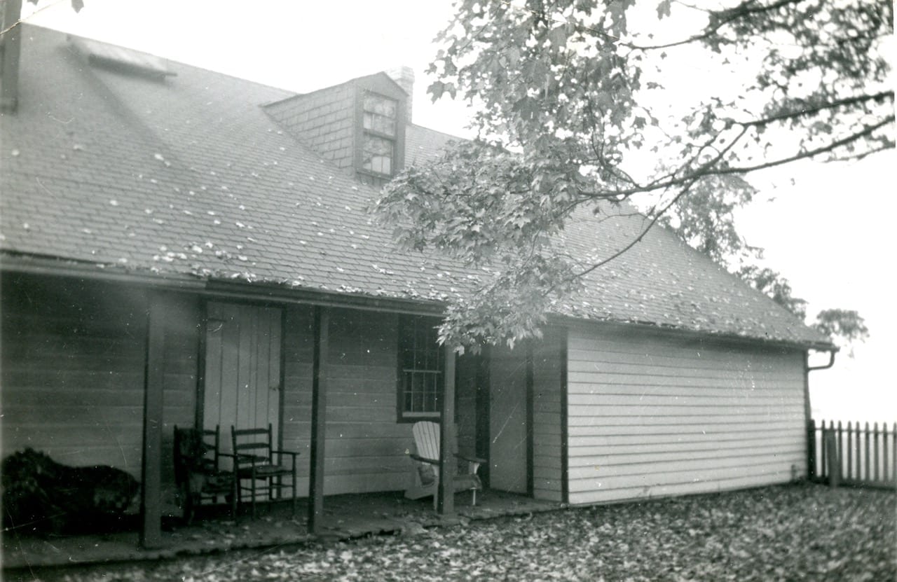
Originally a log cabin to which extensions and siding were added, the colonel’s house near Forty First Street and Lake Shore Blvd. West in Long Branch, was in continuous use for about 152 years, from 1797 until around 1949, before it was bulldozed in 1955.
Occasionally the date 1952 appears, especially online, and on captions on some archival photographs at Montgomery’s Inn, as the purported date of the latter demolition.
The available evidence, however, points definitively to 1955, as is evident from a Feb. 19, 1955 Toronto Star article, accessible at the Toronto Public Library website. From the latter article, it is clear that early in 1955, the Samuel Smith homestead house was still standing, awaiting its imminent demolition. Similarly, a Sept. 9, 1954 article in The Advertiser, about the same house, is entitled “Rare Historical Site Faces Demolition.”
Cottage Country Paradise
Walking west along the Waterfront Trail during a May 6, 2012 Jane’s Walk in Long Branch. The walkers are heading in the direction of Applewood Creek in Mississauga. The trail that you see is where the southern branch of Etobicoke Creek used to flow – in a direction parallel to the trail, and south of it – on its way to Lake Ontario during the Country Cottage era. Mike Foley photo
From the 1920s into the early 1950s, before the arrival of Hurricane Hazel in 1954, the mouth of Etobicoke Creek was known as a Cottage Country Paradise. At any rate, that is the term that the writer, of the text you are now reading, has been using in presentations about the history of Long Branch.
Lake Promenade, which now ends at Forty Second Street, in previous years used to run much further to the west, toward a point that is close to where Applewood Creek in Mississauga flows into Lake Ontario. This is a fact of geography that has been a source of amazement and wonder for some of us, when we have learned of this detail of local history for the first time.

1920 map showing Long Branch (Toronto not New Jersey) subdivision near mouth of Etobicoke Creek. Part of the subdivision is located along the western extension of Lake Promenade west of Forty Second Street.
A still earlier phase of a Cottage Country Paradise – known as Long Branch Park – was established starting in the late 1880s, along the Lake Ontario shoreline near where Long Branch Ave. is located. In 1935, many streets in Long Branch were renamed. Click here to access a list of previous and current Long Branch street names:
Long Branch Street Names – May 13, 1935 document
Long Branch Park was located east of Etobicoke Creek.
In those early days, Long Branch was a beach resort, totally out in the country, a favoured destination for Torontonians who came by boat, disembarking at a long pier near Long Branch Ave. What can be described as the first phase, of a Cottage Country Paradise, served, in the late 1800s and early 1900s, as a high-end summer resort – a gated community, surrounded by a high fence.
The community in the vicinity of Long Branch Ave. has evolved since its Cottage Country days but some of the beach-resort feeling remains in some of the older cottages and houses with verandas and turrets, which remain in place as remnants of the Park era.
“We can think of Long Branch as a lost beach resort area, with turrets, verandas, and porches,” long-time resident David Switzer has commented, in a Feb. 23, 2012 Preserved Stories blog post. “Here you still have buildings that look like there’s sand in front of them, not lawns.”
With some possible exceptions, no cottages remain, however, from the ones that used to exist, during the second phase of a Cottage Country Paradise, at the mouth of Etobicoke Creek. One exception has been described by Norm Kennedy, in a comment at the Preserved Stories website. Norm Kennedy lived on the south side of Lake Promenade during the Cottage Country era, right at the bend in the creek, where the southern branch made its turn before flowing toward the west prior to its exit near Applewood Creek. After Hurricane Hazel, his former house was moved to Thirty First Street, where (as Norm Kennedy has noted in his comment of December 2013), “it stands to this day.”
Subdivisions of Long Branch (Toronto)
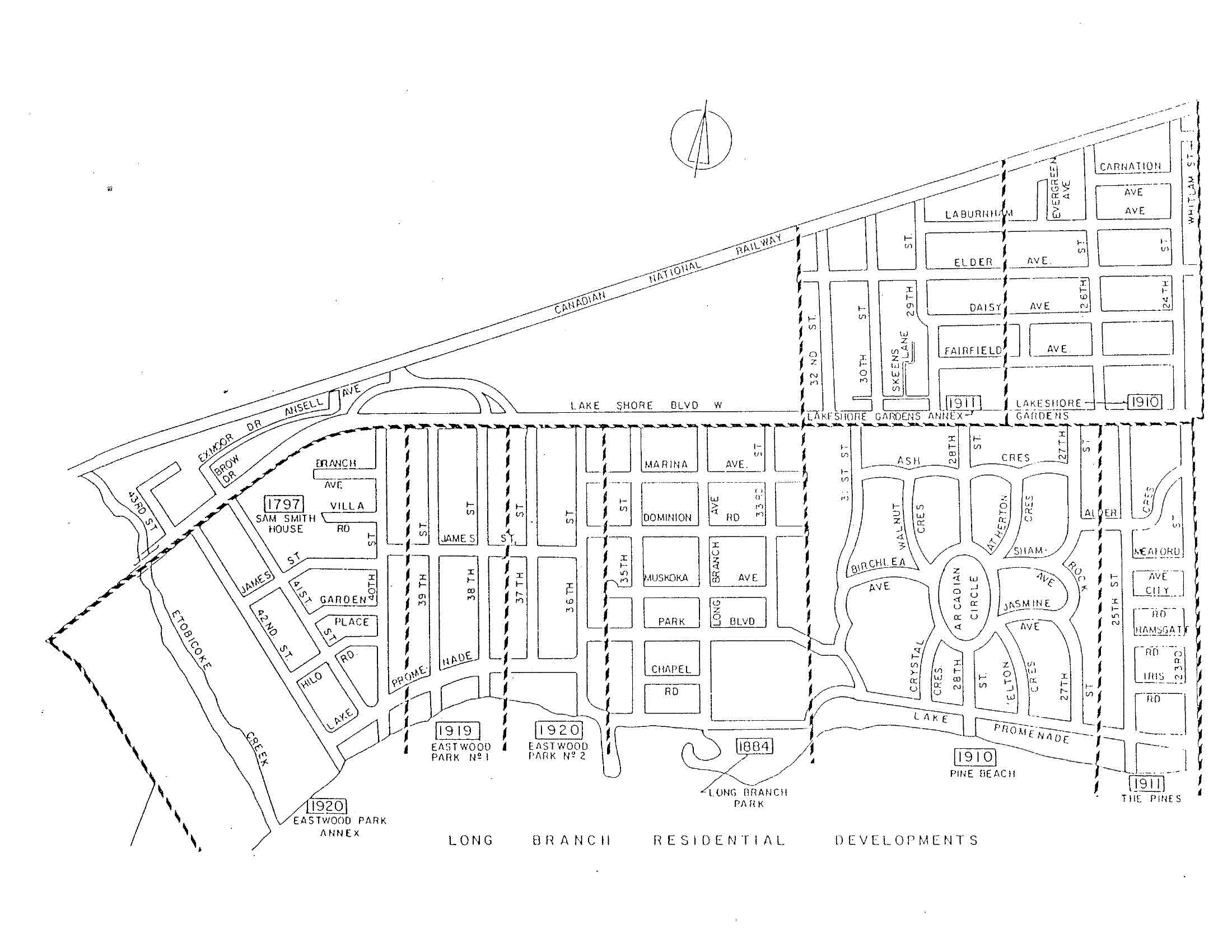
Long Branch Residential Developments. As with other images at this overview, you can get a closer view by clicking on the image.
During the 10,000 years that have followed since the end of the last Ice Age, the land that is now called Long Branch belonged to First Nations peoples; in 1793, however, the ownership passed to Colonel Samuel Smith, who was granted a tract of land that covered all of Long Branch and some ways beyond. After the colonel passed away in 1826, the subdivision of the land began and has been continuing ever since.
Long Branch recreation and landmarks
The name “Long Branch” has been given to many historical landmarks including the Long Branch Rifle Ranges and Long Branch Aerodrome. However, both the rifle ranges and aerodrome were located in what is now the City of Mississauga. The Long Branch Racetrack was another well-known local landmark. Like the rifle ranges and aerodrome, the racetrack was named after Long Branch, but was not located within its boundaries.
Recreational facilities – that actually did exist, in Long Branch itself – have in the past included popular local dance pavilions, fondly remember by residents now in their eighties and nineties, and outdoor music events by the lake.
As work proceeds on the launch of a new residents group, called the Long Branch Neighbourhood Association, it may come to pass that summertime music events, at the gazebo at the waterfront park between Long Branch Ave. and Thirty First Street, will be resumed; they were a popular form of entertainment on summer evenings in the 1990s. The waterfront park is called Long Branch Park; it was built as landfill extending into the lake, years after the original Park had been closed.
Boardwalk at Marie Curtis Park, at a location to the east of the current, channelized version of Etobicoke Creek. During a May 4, 2013 Long Branch Jane’s Walk, Mike James (on left, holding folder), points toward the west where Lake Promenade used to run in the direction of Applewood Creek, during the Cottage Country era. Gay Chisholm photo
Boundaries of Long Branch
South of Lake Shore Blvd. West, the border between Long Branch and New Toronto is Twenty Third Street. North of Lake Shore Road, the eastern border is sometimes indicated as Twenty Second Street, and sometimes as Twenty Fourth Street. The northern boundary is the railway tracks. The western boundary of Long Branch – which also serves as the Toronto-Mississauga border – extends to a point just east of Applewood Creek in Mississauga.
Sometimes, it is assumed that the current, channelized version of Etobicoke Creek, south of Lake Shore Blvd. West, marks the boundary between Mississauga and Toronto. In fact, the border is actually quite a ways to the west of the current version of the creek, which travels north to south, and exits in a straight line into Lake Ontario.

Participants in May 3, 2014 Jane’s Walk on their way along the sand beach from Etobicoke Creek – in the background – to Applewood Creek, where the Mississauga-Toronto boundary is located. The boundary is based on where the western and southern branches of Etobicoke Creek used to run in the Cottage Country era before they were filled in by the mid-1950s. Jaan Pill photo
Etobicoke Creek in this area used to have a western branch, which meant that, along with the still-existing eastern branch, the two branches flowed around an island. A roadway called Island Road ran north to south along the island, during the Country Cottage era. The island is gone, but Island Road remains, although not exactly where the original version of the roadway had been located.
As well, Etobicoke Creek used to have a southern branch which ran parallel to a spit of land along Lake Ontario, and which emptied into the lake near Applewood Creek. By the mid-1950s, the western and southern branches of the creek had disappeared; no evidence of them remains when you walk in the area.
The Mississauga-Toronto border corresponds to where the western and southern branches of the creek used to run. The latter two branches were filled in during the years before and after Hurricane Hazel in 1954. However, the stretch of land where the branches used to run is where the Mississauga-Toronto border, south of Lake Shore Blvd. West, is now located.
North of Lake Shore Blvd. West in Toronto, Etobicoke Creek does indeed act as the border between Mississauga and Toronto.
[End of Introduction]
1. Long Gone Cabin
Colonel Samuel Smith is a name we often hear mentioned, even though it’s been almost 200 years since he passed away. He was born in 1760, over 250 years ago, according to the best available evidence, and died in 1826, which is almost 200 years ago.

Applewood Creek at Mississauga-Toronto border at shoreline of Lake Ontario. The border is located a short ways to the west of the creek. Jaan Pill photo
In December 2010, area residents including children on Villa Road, near the Smith homestead site, celebrated the colonel’s 250th Birthday, on the assumption that he was born in 1760. The archaeologist Dena Doroszenko has cited evidence, in her report on the preliminary archaeological survey that was conducted at the colonel’s homestead site in 1984, that suggests that 1760, and not some other date, is the correct year of birth.
Colonel Samuel Smith Park, at Kipling Avenue and Lake Shore Blvd. West, is also named after him. That’s not in Long Branch, but rather it’s in New Toronto; south of Lake Shore Blvd., the eastern border of Long Branch is Twenty Third Street, which is located to the west of Colonel Samuel Smith Park.
Many of us also know of the Colonel Samuel Smith Skating Trail, located near the old Power Plant at Colonel Samuel Smith Park. That’s a great place to skate in the winter. As well, if you drive your car through the Lakeshore Hospital Grounds where Humber College is located, you will be driving along Samuel Smith Park Drive.
Assuming he was born in 1760, we can say that the colonel was born 256 years ago, as of 2016. Colonel Smith passed away in 1826, which is now 190 years ago, as of 2016. He lived to be 66 years old.
First Nations land ownership
People have lived in Long Branch, or have travelled across it, for thousands of years.
First Nations peoples had ownership of the land in what is now Long Branch for about 10,000 years, ever since Paleo-Indian hunter-gatherers arrived after the end of the last Ice Age. We can add that, according to geological evidence, what are called the Great Lakes were formed nearly 20,000 years ago when the earth’s climate warmed and the last glacial continental ice sheet began to retreat. [In earlier version of this draft, I had links after “10,000 years,” “20,000 years,” and “3,500 to 4,000 years” (next paragraph) but the links are no longer available; if I get around to it, I’ll find alternative citations.]
Roughly 3,500 to 4,000 years ago, what we now call the Great Lakes attained their modern levels and area. The shoreline of Lake Ontario, which defines the southern boundary of Long Branch, has not always been where it is now.
Long Branch was once located under the waters of Glacial Lake Iroquois, and at other times has been located some ways north of the shoreline of the lake. The latter scenario was during the Lake Admiralty phase when the lake shrank in size.
The suitability of the soil of Long Branch for farming, once the forests had been cleared, is a result of processes that occurred during the time the land was under Glacial Lake Iroquois.
The shoreline where Long Branch is now located has wandered north of its current location during the Glacial Lake Iroquois phase when Lake Ontario expanded, and south of it during the Lake Admiralty phase when the lake contracted.
A good resource regarding these topics is The Physiography of Southern Ontario (1984).
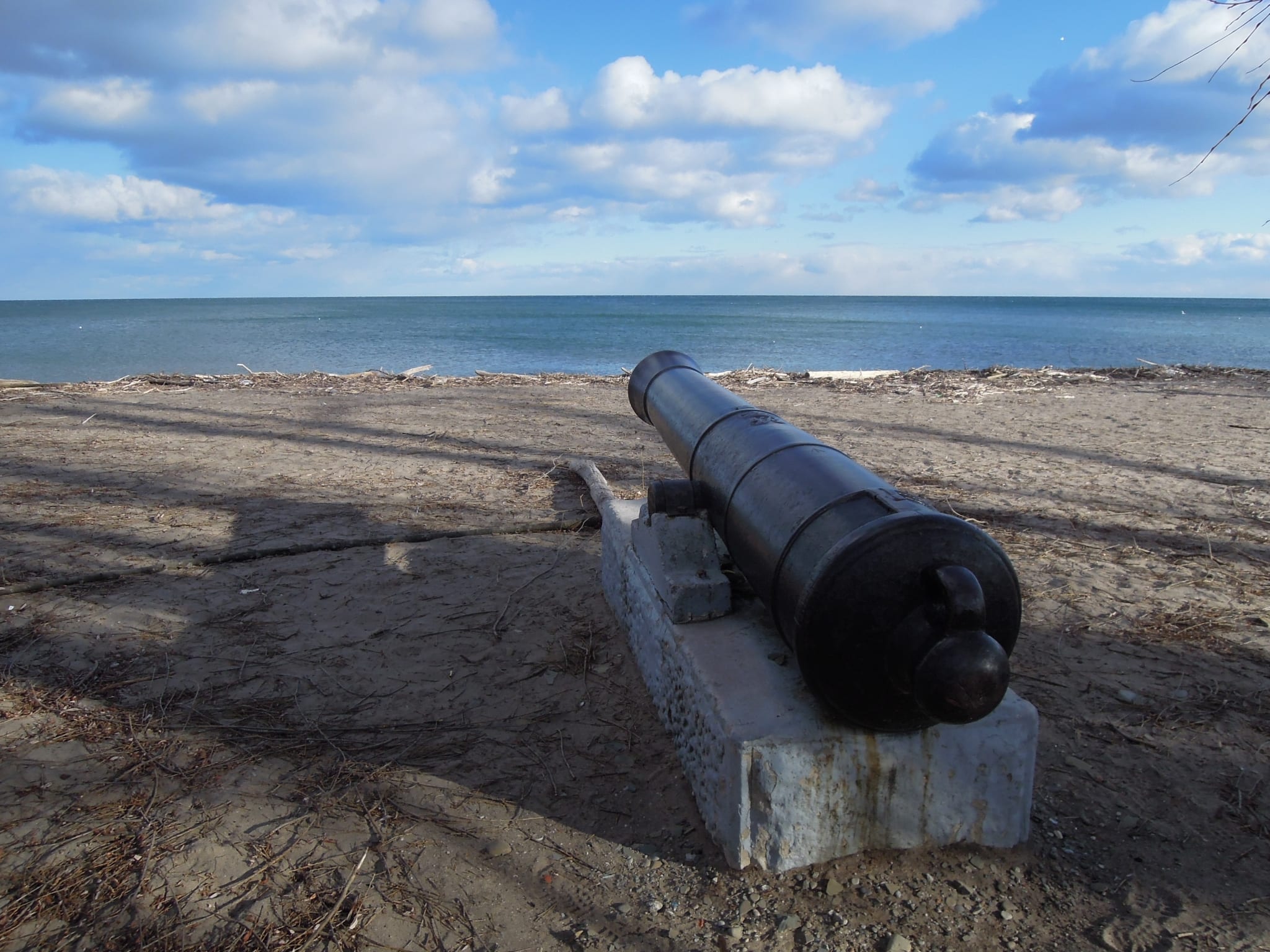
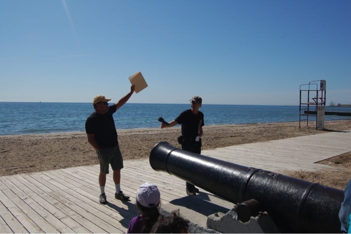
A heavy gun, a retired cannon, is located at Marie Curtis Park in south Etobicoke. You can read more about the cannon by doing a Google search for “Cannon at Marie Curtis Park Preserved Stories.” The photo was taken before the construction of a boardwalk along the beach. Jaan Pill photo
Settler land ownership
When the British arrived in the area, they set up a European system of land ownership. Much has been written about the rise and fall of the British empire. In the late 1700s, the empire was at its ascendancy. It featured characteristics common among empires throughout history.
A passage (p. 196) from The Silk Roads: A New History of the World (2015) describes the features of such empires as follows: “Europeans were able not only to explore the world but to dominate it. They did so thanks to the relentless advances in military and naval technology that provided an unassailable advantage over the populations they came into contact with. The age of empire and the rise of the west were built on the capacity to inflict violence on a major scale.”
A description of the procedures, whereby Western settlers appropriated the land, in what was called the “new world,” from Indigenous peoples who had maintained ownership – and sustainable use – of it for many centuries, is available in a study entitled The Great Land Rush and the Making of the Modern World (2003).
The first landowner in Long Branch, in accordance with the European settler system of land ownership, was Colonel Samuel Smith, who was born in what is now New York State before the American Revolution. Smith was a Loyalist officer who fought on the British side as an officer of the Queens Rangers during the American Revolutionary Wars.
The Queens Rangers was a distinguished Loyalist military unit led by John Graves Simcoe, who served as lieutenant governor of Upper Canada after the American Revolution. Samuel Smith and John Graves Simcoe were colleagues in wartime and good friends as well.
In 1793 Smith was granted a large tract of land, which covered all of what is now Long Branch an extended quite a ways beyond.

Aerial view looking east along Lake Shore Blvd West from near Long Branch Loop, Ontario Archives Acc 16215, ES1-814, Northway Gestalt Collection. As with other images on this page: Click on image to enlarge it.
Smith owned a lot of land in Long Branch as well as land in what is now downtown Toronto. His property in Etobicoke extended from the shoreline of Lake Ontario, all the way north to Bloor Street West, and it extended from Kipling Ave. on the east all the way to Etobicoke Creek on the west
That’s a lot of the land for one person to own. Although he was a big-time landowner, however, he was not a wealthy man as he lived on a very small pension as a retired military officer. When he died, his offspring experienced poverty. Given that class and status drove the British empire, as historian David Cannadine has argued in Ornamentalism: How the British Saw Their Empire (2001), the circumstance of poverty would have been challenging for his offspring.
Samuel Smith has a very close connection to Long Branch. In 1797, he built a log cabin, positioned east to west, facing the lake, in the forest near where Lake Shore Blvd. West and Forty First Street are now located. The cabin was built north of Lake Ontario, east of Etobicoke Creek, and south of where the Long Branch TTC Loop is now located. To be precise, it was built where the school grounds of the former Parkview School, at 85 Forty First Street, now stand.
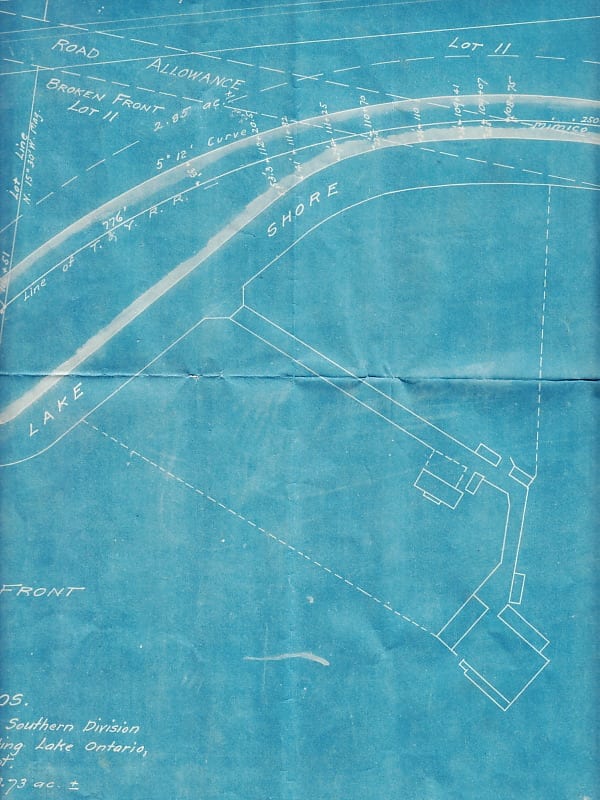
Detail from July 21, 1905 survey prepared for Eastwood Brothers.
The cabin that Col. Smith built in 1797 had many rooms added to it over the years and a farm was developed on the land. Siding and extensions were added to the cabin as the years went by.
When the house was demolished in 1955, the original log cabin was discovered inside the building. It was noted that the cabin was very sturdy and not easy to demolish. A Feb. 19, 1955 Toronto Star article notes that the contractor who was given the task of demolition had been talking about salvaging the logs by turning them into boards of lumber. The barns and other buildings that were on the farmstead were also demolished around the 1950s.
Archaeological remains of Samuel Smith homestead site
Most of the archaeological remains of the homestead have remained in place under the school grounds of the former Parkview School – currently known as l’École élémentaire Micheline-Saint-Cyr (previously also known as St. Josaphat Catholic School and before that, as Parkview School). The colonel’s house was located in what is now an open space, just south of where a baseball backstop stood until recently, close to some townhouses at the northeast corner of the school grounds.

Radial bridge over Highway 2 (now Lake Shore Blvd. West) – 1927. As noted in Motorcycle: The Definitive Visual History (2012), the Henderson motorcycle, featured in the photo, was popular with police forces as they were very fast. Roads between cities were unpaved; the Henderson featured effective suspension, rugged construction, and “forms of gearing to cope with hilly terrain.” Photo © Durance family and Robert C. Lansdale
The colonel’s house was in continuous use for about 152 years from 1797 until around 1949, before the house was demolished in 1955. The site of the house was thoroughly razed – cleared out by a bulldozer – to the extent that little archaeological evidence of the existence of the building remains.
Dena Doroszenko, an archaeologist, did a preliminary archaeological dig at the Parkview site in 1984. She has suggested that the artifacts from the building may have ended up in the embankment that was built up in an area of the school grounds located immediately to the north of a baseball backstop that used to be in place at the school grounds until recently.
2. Keeping Parkview School in public hands
A more recent story concerns the efforts by the local community, which eventually proved successful, to keep Parkview School in public hands.

View of school grounds, looking north toward Lake Shore Blvd. West, at former Parkview School. View of school grounds, looking north toward Lake Shore Blvd. West, at former Parkview School. The school was subsequently renamed as St. Josaphat Catholic School; its current name is l’École élémentaire Micheline-Saint-Cyr. Jaan Pill photo
In October 2010, residents close to the school learned that the Toronto District School Board (TDSB), which owned the property, was planning to sell Parkview School, as it had been declared as being surplus to its needs. The school had not been in use as an elementary school for some years. It had been built in the late 1950s to accommodate large numbers of baby boomers.
In 2010 there was a concern that the school would be sold to a developer, who would build condos or townhouses at the site. The local residents organized a massive, two-stage letter writing campaign, with the aim of keeping the school property in public hands.
With the help of a large number of participants, the letter writing project led to a successful outcome for the community.
On August 25, 2011, the Ontario government announced that it would provide $5.2 million in funding to enable the sale of the school, by the Toronto District school Board, to the to the French public school board, Conseil scolaire Viamonde.

View of l’École élémentaire Micheline-Saint-Cyr (formerly Parkview School), photographed from top of Aquaview Condominiums, November 2012. Click on image to enlarge it. Jaan Pill photo
The sale of Parkview School has turned out to be a “good news” story thanks to the efforts of Etobicoke-Lakeshore MPP Laurel Broten; Ward 3, Etobicoke-Lakeshore TDSB Trustee Pamela Gough; officials at the Toronto Lands Corporation; the large numbers of people who wrote letters in support of keeping Parkview School in public hands; and several key individuals who shared strategic advice.
Among other things, the strategic advice was that, in the circumstances, individually written letters would have a greater impact on decision makers than simply having people add their signatures to a petition. Writing a letter takes more time and energy than signing a petition, and the people who would be receiving the letters would take note of that.

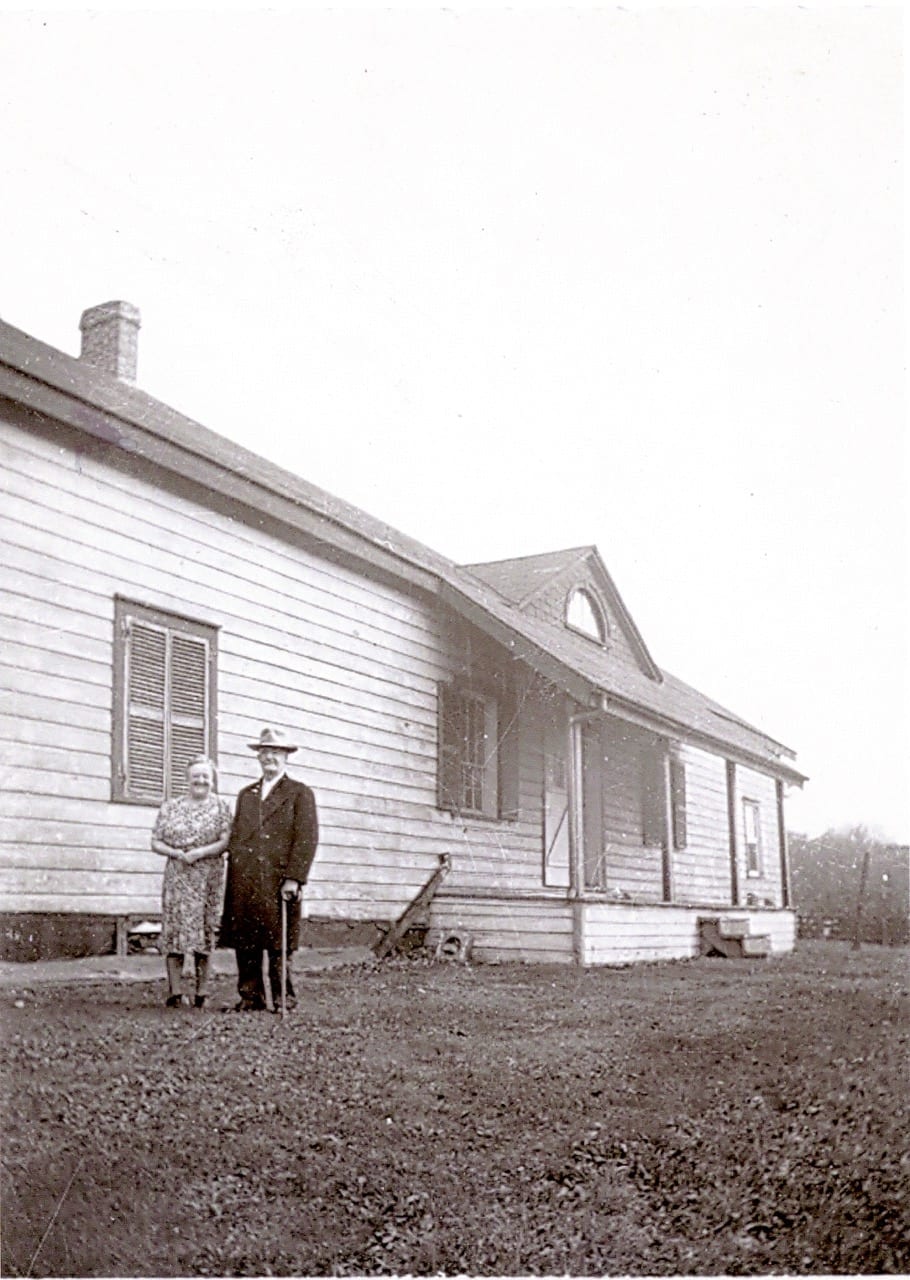
Back view (facing south) of Colonel Samuel Smith homestead house, located at what are now the school grounds of Parkview School. Originally a log cabin, built in 1797, the house had siding and extensions added to it over the years. Photo © Betty Farenick and family
At one point, residents learned that the negotiations for the sale of the building had stalled. They decided to launch a second letter writing campaign, to underline their keen interest in ensuring that the sale of the school, from one school board to another, would come to pass.
The residents owe thanks as well to Jim Gill, a former president of the Long Branch Historical Society who arranged for the preliminary archaeological dig at the school in 1984, conducted by archaeologist Dena Doroszenko. The archaeological evidence related to the Parkview School property was a key talking point in the letters that large numbers of residents sent out.
Front view (facing north) of Samuel Smith house, on what are now the school grounds of Parkview School. Photo © Betty Farenick and family
A French elementary school, École élémentaire Micheline-Saint-Cyr, is currently located at the site. Another school board, the Toronto Catholic District School Board (TCDSB), had leased the school property right after the sale. The property, which was renamed St. Josaphat Catholic School when it operated as a TCDSB school, has served as an elementary school since September 2012.
The school has been extensively renovated and the grounds have been cleaned up and subsequently extensively landscaped. The grass in the green space is now neatly trimmed; the entire property communicates a sense of renewal. The grass was cut in the past but now the work has been done in recent years with additional care. It has been a delight for residents to walk by the school and see the changes.
Betty Farenick, age about 16, visiting her uncle Robert Christopherson at the Samuel Smith house (the photo was taken at the back of the house) in the 1940s. Photo © Betty Farenick and family
Every day during the week during the school year, you can see school children playing on the school grounds during recess periods. When the school is closed on weekends and in the summer, the grounds provide a green space for local children and adolescents to play games of soccer, baseball, and touch football. It’s also an ideal venue for dog walking, playing with a Frisbee, and riding a bicycle. In the winter, neighbourhood children are often seen tobogganing and snowboarding at the embankment at the northern boundary of the grounds.
Rural farmstead transformed into a last remaining urban farmstead
Like the Ashbridge Estate east of the Don River, the colonel’s property began as a rural farmstead that was transformed into an urban farmstead surrounded by a growing city. The two farmsteads are mirror images of each other. As the archaeologist Dena Doroszenko has noted, one day the occupants of each farm were living in the countryside; and then the day arrived when the surrounding countryside had disappeared.
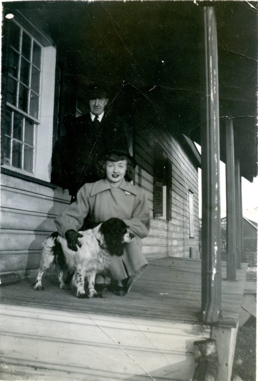
Nell and Robert Christopherson at the back of the Samuel Smith house, where they lived until 1952; the house was torn down in 1955. Photo © Betty Farenick and family
The colonel’s property began as a rural farmstead, which in time was transformed into an urban farmstead surrounded by a growing city. As the years passed, the occupants of the farm observed a dramatic change in their surroundings, without having travelled anywhere. What had been a farm out in the countryside became, with the passage of the years, a farm that was on its way toward being engulfed by a growing city.
Open spaces
In the early years of its development, starting with the subdividing of lots after the 1880s, much open space was available in Long Branch. As archival aerial photos indicate, years ago empty fields were everywhere, much to the enjoyment of neighbourhood children seeking places to play. Over the years, such empty fields have vastly diminished. The remaining open spaces, such as at Parkview School, serve as valuable and much appreciated resources.
3. Cottage Country Paradise, at two distinct locations
The mouth of Etobicoke Creek, according to A Glimpse of Toronto’s History: Opportunities for the Commemoration of Lost Historic Sites (2001), was once known as one of the finest wetlands and wildlife habitats along the Lake Ontario shoreline. In the past, when the area was in its natural state, according to the above-noted study, annual spring floods brought nutrients to the lands at the mouth of the creek. Marshes in the area provided spawning grounds for fish. Salmon would travel upriver to spawn. First Nations peoples grew corn, and later also squash and beans, on the floodplains at the mouth of the creek.
The first Europeans to settle in the area were Colonel Samuel Smith and other Loyalist soldiers who arrived in the late 1700s after the American Revolutionary Wars.

Durance family by Etobicoke Creek. Photo credit: Durance family Photo © Durance family and Robert C. Lansdale
From the 1920s into the early 1950s, before the arrival of Hurricane Hazel in 1954, the mouth of Etobicoke Creek was known as a Cottage Country Paradise. Lake Promenade, which now ends at Forty Second Street, in those years extended close to Applewood Creek along the Lake Ontario shoreline, to a point where the Mississauga-Toronto border is now located.
A second Cottage Country Paradise existed at another location, a short ways to the east of Etobicoke Creek, as well.
The first location that we will address is the cottage community that used to exist at the mouth of Etobicoke Creek and along the Lake Ontario shoreline, between the current channelized version of Etobicoke Creek (south of Lake Shore Blvd. West) and along the Lake Ontario shoreline.
The second cottage community, established in the late 1880s, before the community at the Etobicoke Creek mouth had been established, was at Long Branch Park along the shoreline near Long Branch Avenue to the east of Etobicoke Creek. The latter resort had direct access to the lake.
During its early history, Lake Promenade, going west to east, ended roughly where Long Branch Ave. is now located. Going east from the corner of Long Branch Ave. and Lake Promenade was a beachfront where the Long Branch Hotel was located. Further east, at a point not far from where the corner of Thirty First Street is now located, Lake Promenade again made its appearance and travelled further east, toward New Toronto and the Lakeshore Hospital Grounds.

Oblique view of Marie Curtis Park including mouth of Etobicoke Creek, May 2010. Photo © Toronto and Region Conservation Authority (TRCA)
Etobicoke Creek
Colonel Samuel Smith was the first landowner, under the British system of land ownership, in the area. Originally, big forests of oak and pine covered his property, which extended across Long Branch and beyond.
As the above-noted 2001 study notes, the colonel left most of Etobicoke Creek as he found it. Starting in 1797, he built a homestead not far from the creek. The colonel also allowed the cutting of timber on his land. By 1842, half of the great forests of the area had been cut down. Because the trees were cut down, serious flooding problems, at the mouth of Etobicoke Creek, began about 1850.
Colonel Samuel Smith passed away in 1826. Many years later, in 1871, Col. Smith’s Samuel Bois Smith son sold 500 acres of the Smith property to James Eastwood.
James Eastwood sold large numbers of oak and pine trees, from the forests that existed on his property. The logs were rafted down Etobicoke Creek on their way to Toronto, where they provided lumber for the building of houses.
Lake Promenade
Lake Promenade is a roadway that runs east to west in Long Branch along the Lake Ontario shoreline. Currently, if you stand at the corner of Lake Promenade and Forty Second Streets, you are standing at the western end of Lake Promenade. That’s where Lake Promenade ends if you are traveling to the west toward Mississauga.
In previous years, however, during the Cottage Country era, Lake Promenade extended far to the west of where it now ends.
It extended all the way to the west almost as far as Applewood Creek, where the boundary between Mississauga and Toronto, at the Lake Ontario shoreline, is located. The municipal boundary is located a short ways east of where Applewood Creek flows into Lake Ontario.
The roadway used to run along a spit of land that extended east to west in the years before Hurricane Hazel. You could describe the spit of land as a peninsula that had been growing, thanks to deposits of sediment, toward the west for many years.
In the past, Etobicoke Creek didn’t flow in a straight channel, north to south, directly into Lake Ontario, as it does now. Instead, there was a western branch to the creek, which has now been filled in, as well as an eastern branch. The two branches of the creek formed an island, on which many summer cottages were located. At the south end of the island, Etobicoke Creek made a turn, and ran for quite some distance, to the west, before it emptied into Lake Ontario near Applewood Creek.
Flooding along Etobicoke Creek
The story, as it relates to cottages, as outlined in A Glimpse of Toronto’s History (2001), begins in the 1850s, when half of the original forests, which had used to exist in the area for the previous 10,000 years, were cut down and sold for timber.
After the trees were removed along the floodplain at the mouth of Etobicoke Creek, people began to build shacks along the creek. When the trees and wetlands were in place, flooding had not been a problem for anybody in the area. Once the trees were gone, the floodplain at the mouth of the creek would get flooded on a regular basis.
As a next step, work that was undertaken in 1929 set the stage for even larger amounts of flooding that occurred in the years after the Second World War.
In 1929, the peninsula, or spit of land, or sandbar – that extended east to west along the Lake Ontario shoreline, running parallel to the southern branch of Etobicoke Creek – began to be built up, in order to enable Lake Promenade to run all the way from Forty Second Street to Applewood Creek.
What that work meant was that, when flooding occurred, there was no way for the water to find its way to Lake Ontario.
Severe flooding occurred in 1948 because of the work that had been undertaken to build up the roadway.
In 1952, more flooding occurred and more houses were destroyed. After Hurricane Hazel arrived in 1954, it was decided to get rid of all of the houses in the area and turn the mouth of the creek into a park. That’s how Marie Curtis Park, named after a local politician, came into being.
The moral of the story is that a floodplain is not a good place to build houses. This is a point that is underlined in a classic text about the geological history of southern Ontario entitled The Physiography of Southern Ontario (1984).
That’s being said, the cottages at the mouth of Etobicoke Creek gave Long Branch (which was not yet a part of Toronto) and Toronto residents an opportunity to spend enjoyable summers by the lake for several decades prior to the mid-1950s.
Some people who have contacted the Preserved Stories website in recent years have said that playing at the most of the Creek, in the early 1950s as young children, were among the happiest times of their lives.
A second moral of the story is that the mouth of Etobicoke Creek serves as “a textbook illustration,” as A Glimpse of Toronto’s History (2001) notes, “of the damage done by human interference.” What was once a “major wildlife habitat and scenic beauty location,” the 2011 study notes, has been “engineered out of existence.”
It may also be noted that such studies – as is also the case with contemporary newspaper articles and the works of local historians – occasionally include factual errors, whose existence can be determined by comparing statements from a wide range of sources. For example, the above-noted 2001 document claims that Col. Smith was granted a 1,600-acre tract of land in 1799 whereas most (authoritative) sources note that Smith was granted the tract in 1793. It may also be noted that he built his log cabin in 1797, which is prior to the year of 1799 referred to in the study.
Long Branch Park
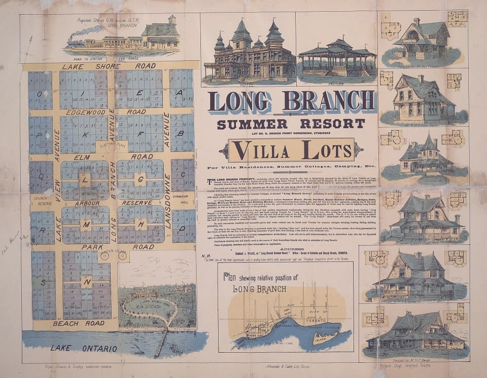
Poster of Long Branch Park development. The poster is entitled: “Long Branch Summer Resort lot no. 9, broken front concession, Etobicoke villa lots for villa residence, summer cottages, camping, etc.” Details on how to order a copy of the poster are available at a Toronto Public Library webpage entitled: “Collection Reproduction and Digitization on Demand.” The current names of streets in the area can be accessed at an archival document: Long Branch Street names – May 13, 1935.
Another chapter in the story about the Cottage Country Paradise began to the east of Etobicoke Creek along the shore where Long Branch Avenue is now located.
The Long Branch Park development was started in the late 1880s and became a summer resort – Cottage Country at its finest – for vacationers from Toronto. In those days, Long Branch was totally out in the country; the main means of access from Toronto was by boat. City people went to Long Branch in the summertime, leaving behind the stresses of late-1800s city life. Long Branch offered visitors rest and recreation, in a wilderness area by the lake.
Colonel Samuel Smith passed away in 1826. In 1871, James Eastwood bought 500 acres of land from the Colonel Samuel Smith family. In 1883, James Eastwood sold 75 acres of the eastern portion of the property, which was subsequently developed into a summer resort called Long Branch Park.
There are several versions of how the name was chosen. A widely accepted one is that the developer of Long Branch Park, Thomas Wilkie, was an American who had reputedly vacationed at a summer resort, called Long Branch, which had been developed many years earlier in New Jersey. There is some evidence, that is – albeit the evidence is not definitive – that the park’s name may have been copied, by the developer, from Long Branch in New Jersey.
The Long Branch Hotel, a popular destination for wealthy citizens from Toronto, was completed in 1887 and destroyed by fire in 1958. A blowtorch used to thaw some frozen water pipes set the building on fire, according to Bill Rawson, who lived close to the hotel in those years.

Harold Snelgrove, age 2, enjoying a visit to Long Branch in July 1915. The exact location of the photo is unknown, although the cottages in the background may provide a clue. Please contact Jaan Pill at Preserved Stories in the event you have definitive information that may help us to determine the location. Photo © W.J. Snelgrove family
The developments of cottages in the surrounding area, close to Long Branch Park, began in 1910, according to notes that Long Branch resident (and former Long Branch and Ontario politician) Ruth Grier has shared from a Jane’s Walk that she led in the area in 2010. The cottage era in this area lasted until the 1930s, by which time many cottages had been made into permanent homes. Some of those cottages are still standing along Lake Promenade and elsewhere in Long Branch.
Alistair Thomson’s recollections
An Oct. 18, 2013 comment from Alistair Thomson at the Preserved Stories website reads:
“I lived at 282 Lake Promenade from 1948 to 1968. The house was one of the original summer homes built in 1887. I lived through hurricane Hazel when I watched the huge 80 feet tall trees tumble into the lake. The next day I was standing close to a huge Walnut tree as it fell in. There was a row of farm fence nailed to the tree, which I grabbed and climbed up the embankment. Half-way up a water main burst but by that time I had scampered back to the road. I was about 12-years-old at the time. The Toronto Telegram sent a reporter to interview me. I was a local celebrity.
“It was a great place to grow up. We were the wildest bunch of kids. But most of the old gang is dead.”
In another comment on Oct. 18, 2013, Alistair Thomson adds:
“My family’s house was on the corner of Lake Promenade and 35th St. On the opposite corner 278 Lake Promenade lived Harris Burgess, who, at 99-years-old, passed away. At the other end of the block, 294 Lake Prom, lived the Horchover family. Great people. Salt of the earth. I think they are all dead now.
“It was a magical place in which to grow-up. The summers were like something from Mark Twain. One time we decided, we were like a real-life group of little rascals, to have an Indian Club. There were vacant lots everywhere and we appropriated the lot next to the Horchovers. We built teepees and wigwams and dug fire pits and in general made a mess of the place. No one bothered about the mess though. We were just the neighborhood kids.”
Bernice Law’s recollections
In response to the above-noted comments, Jaan Pill wrote the following Oct. 18, 2013 comment at the Preserved Stories website:
“This is wonderful to know about! What a tremendous amount of great information you’ve shared, Alistair. I’ve heard from many sources that kids used to have a wonderfully good time growing up, often making up their own games and activities, in Long Branch.
“I did an interview this morning (Oct. 18, 2013) with Bernice Law, who was born in 1924 and lived at 86 Forty First Street, at a house that her father built. We drove around Exmoor Drive and along Forty First Street and then down James Street, after which we drove along Lake Shore Blvd. West to the parking lot at the west side of Marie Curtis Park. We would stop the car to talk, at different points along the way.
“Bernice explained to me the changes in the configuration of the land, and told me about the garages that were located to the west and east of the corner of Forty First Street and Lake Shore Blvd. West. I was able to show a map of where the radial railway used to run and where it crossed Etobicoke Creek. She also told me great stories about the three police officers including a great police chief [named Smythe] who patrolled the area and were very helpful in ensuring the safety of children as they travelled about the community.
“Bernice Law mentioned that in the 1930s, the cottage community on Lake Promenade – in days when Lake Promenade extended westward, along where the south branch of Etobicoke Creek used to run – were a very active community. This was especially the case for residents living on the south side of Lake Promenade at that location.
“They would organize all manner of events including regattas and one where people try to climb a greasy pole. She told me all kinds of things that we’ll be able to share [in future, when the interviews with Bernice have been transcribed].”
End of Cottage Country Paradise
As the years passed, the cottage country years of Etobicoke Creek and of Long Branch Park came to an end. Around Etobicoke Creek, the end came with Hurricane Hazel.
The Long Branch Resort development was wiped out in a different way. The areas around the park began to be developed, as Ruth Grier has mentioned, in notes referred to earlier, with the arrival of new residents traveling to Long branch by a new streetcar line.

At April 18, 2015 meeting at Long Branch Library, Ward 1, City of Mississauga Councillor Jim Tovey highlights key features of Lakeview Waterfront Connection Project. Jaan Pill photo
What the future holds for the Lake Ontario waterfront
If you want a positive view of what the future holds for the Lake Ontario waterfront, a good place to look is to the west of Etobicoke Creek. Many exciting things are happening in Lakeview, to the west of Long Branch. These include a project called Inspiration Lakeview and another project called the Lakeview Waterfront Connection Project. If you want to learn more about the projects, you will find details at the Preserved Stories website.

At “Jane’s Walk – How To” meeting at Long Branch Library on April 18, 2015, Jim Tovey, former president of the Lakeview Ratepayers Association, outlines history of Lakeview Legacy Project. Jaan Pill phot
A key distinction between how waterfront development is approached at the City of Toronto, as contrasted to the City of Mississauga, also warrants mention. In Toronto – as evidenced, by way of example, along the Lake Ontario waterfront at Humber Bay Shores between Park Lawn Road and the Humber River – tall condos along the Toronto waterfront are a common sight. At the City of Mississauga, by contrast, a policy is in place that ensures that no tall condos will be built along the Mississauga waterfront.
4. Subdivisions of Long Branch
In the 10,000 years that followed the end of the last Ice Age, the land belonged to First Nations peoples; in 1793, the ownership passed to Colonel Samuel Smith, who was granted a tract of land that covered all of Long Branch and some ways beyond. After Colonel Smith passed away in 1826, the subdivision of the land began and has been continuing ever since.
The property that used to be the Samuel Smith homestead, where Parkview School is now located, was subdivided in the 1950s. Part of it was set aside for a school building and schoolyard. To the north of the school building, a gas station and a Dominion store were set up, at an early stage of the subdivision process.
The gas station was replaced in time by a condo building located near the corner at Forty First Street and Lake Shore Blvd. West south of the Royal Canadian Legion building and the Long Branch GO station. The Dominion store, as well, was in later years replaced by a low-rise residential development north of the schoolyard.
The Ontario government announced in August 2011 that it would provide $5.2-million in funding to enable the French public school board Conseil scolaire Viamonde to purchase Parkview School from the Toronto District School Board. As a result, the local public school property in that part of Long Branch has been saved from further subdivision, by a developer who might have put up condos or townhouses at the site of the school.
James Eastwood
A major step in the process of subdivision, which has been going in the years after Colonel Samuel Smith had passed away, began in 1871, when the colonel’s son, Samuel Bois Smith, sold the Smith house and 500 acres of the colonel’s land to James Eastwood.
James Eastwood sold oak and pine, from the forests on the property, and rafted logs down Etobicoke Creek to Toronto, where the wood was used for the building of new houses.
As mentioned in the 2010 Jane’s Walk notes prepared by Ruth Grier, referred to earlier, in 1883, James Eastwood sold 75 acres of the eastern portion of the property, which was subsequently developed into a summer resort named Long Branch Park.
The Long Branch Hotel, a popular destination for wealthy citizens from Toronto, was completed in 1887 and destroyed by fire in 1958. The hotel’s dock was a 45-minute boat ride from the end of Yonge Street. A high fence to keep out rowdy intruders surrounded the hotel property.
Development of cottages in the surrounding area began in 1910. The cottage era lasted until the 1930s, by which time many cottages had been winterized into permanent homes. When the Village of Long Branch was incorporated in 1931, it set up its own police force. Houses along Lake Promenade represent a range of architectural styles. Several old cottages west of Long Branch Avenue remain from an earlier era. The foregoing information is based upon the notes that Ruth Grier had prepared for a Jane’s Walk that she led in Long Branch in 2010.
Postwar subdividing of lots
According to the notes prepared for a May 2010 Jane’s Walk led by Ruth Grier, after the opening of the Queen Elizabeth Way in 1939, plans to attract more residents led to bylaws, which allowed 50-foot lots and small apartment buildings. After the Second World War many veterans were given lots and larger properties began to be subdivided.
In 1954 the Municipality of Metropolitan Toronto was created as a federation of smaller municipalities. In 1967 a further change in municipal organization led to the creation of the Borough of Etobicoke, at which time, as Ruth Grier mentions in her 2010 notes, the Village of Long Branch lost its independence.
Corporate logo of the Village of Long Branch (Toronto). Source: Long Branch Historical Society
Village of Long Branch
During the the years around the time of Hurricane Hazel and after, there was some industry on the north side of Lake Shore Blvd West, as David Switzer has noted at a Feb. 23, 2012 Preserved Stories blog post. At an earlier time it may have been considered a village.
It had a single main street – which is now called Lake Shore Blvd. West, and which had its beginnings as an Aboriginal trail through the forests, running within sight of the Lake Ontario shoreline – that contained a theatre, bowling alley, grocery store, doctors, drugstore, a Woolworth’s, barber shop, and churches.
Long Branch in those days, as David Switzer has remarked, had all that was necessary to live without leaving the community except for the external trips that most villagers take to destinations such as a hospital, a big-city play, a museum, or professional sports events. Lacrosse was a sport that was highly popular in the communities along the Lakeshore in those years.
There was adequate transportation for the above-noted trips but most were done by car, David Switzer has noted. The local industry provided some jobs and others were close by.
Long Branch Neighbourhood Association
In recent years, severances of 50-foot lots into two 25-foot lots in Long Branch have become a source of local concern. Residents have recently launched a new group, the Long Branch Neighbourhood Association, with the aim of ensuring that when planning decisions are made, that affect the Long Branch neighbourhood, the interests of local residents are taken into account. Based on an extensive survey, the mandate of the new association seeks to:
- Protect the physical character of Long Branch
- Celebrate the neighbourhood and its history through events and community gatherings
- Enhance the public realm of the neighbourhood and the quality of life in the community
5. Recreation and Landmarks of Long Branch
The name “Long Branch” has been given to many historical landmarks including the Long Branch Rifle Ranges and the Long Branch Aerodrome – which was Canada’s first aerodrome. However, both the rifle ranges and aerodrome were actually located in what is now the City of Mississauga. The Long Branch Racetrack was another well-known local landmark – which in this case was located north of Long Branch, outside of its boundaries.

Baffles are among the few surviving remnants of the Long Branch Rifle Ranges in the green space south of the Small Arms Building in Lakeview, Mississauga. Jaan Pill photo
We can say that there is something about the name “Long Branch” that appeals to people, even if they do not live in Long Branch. It can be said, perhaps, that Long Branch is a state of mind as well as a physical neighbourhood with specified borders. Many of the people who have contacted the Preserved Stories website, in recent years, to talk about the Long Branch that they experienced years ago, now live in cities or rural areas across North America. Such former residents, or previous visitors, as the case may be, retain fond memories of their unique and memorable encounters with the Village of Long Branch.
In Lakeview: More Than Just Land, Vol. 1 (1990), Verna Mae Weeks notes (p. 41), that a rifle range had originally been set up about 1868 at Garrison Common at the waterfront in Toronto. However, in March 1881 the City of Toronto, concerned about the safety of its residents, asked that the rifle range be removed to a place outside the city. A location was chosen near Port Credit but the new rifle ranges, which was spread along the waterfront in what is now Lakeview in Mississauga, came to be known as the Long Branch Rifle Ranges even though the range was not in Long Branch. Lakeview in those days was part of what was called Toronto Township. More details about the rifle ranges are featured below.

Baffles at Long Branch Rifle Ranges located between Lake Ontario shoreline and the Small Arms Building in Lakeview, Mississauga. Jaan Pill photo
In subsequent years, Canada’s first aerodrome was set up on land that had a connection to the Long Branch Rifle Ranges, and consequently became known as the Long Branch Aerodrome.
Recreational facilities – that actually did exist, right inside of Long Branch – have in the past included local dance pavilions, and outdoor music events by the Lake Ontario shoreline. As work proceeds in the launch of the Long Branch Neighbourhood Association, it may come to pass that summertime music events, at the gazebo at Long Branch Park, will be resumed.
Long Branch Racetrack
The racetrack is actually located north of Long Branch. Its connection to Long Branch is through its name and its proximity to the northern boundary of Long Branch. You can find a plaque on Horner Avenue, on the north side, just east of the railway tracks to the west of Kipling Ave., that describes the Long Branch Racetrack.
The plaque is covered in graffiti and is unreadable, although you can see, on the plaque, part of an archival aerial photograph of the racetrack. Fortunately, the text that is on the plaque is available online. The plaque notes that a tall brick and stone gatepost directly opposite the plaque was one of two gateposts marking the main entrance to the racetrack. An avenue of maple trees, which still survive, highlighted the entrance further.
The site covered an area, the plaque notes, that had Evans Ave. on the north, Kipling Ave. on the east, Horner Avenue on the south, and the Canadian Pacific Railway tracks on the west. It covered a huge amount of land.
As the plaque adds, the Orpen family operated the Long Branch Racetrack between September 6, 1924 and October 21, 1955. On December 1, 1955 the Track was sold to Toronto Racing Securities Limited, which closed the facility with the development of the new Woodbine Racetrack in Rexdale.
Each year thousands of racing fans, the plaque notes, would flock to the racetrack for thoroughbred and standardbred races. Race meetings were usually held in the late summer or autumn. The racetrack is notable as the site of a number of races that are still featured in Canadian racing.
The Canadian International Championship was first run as the Long Branch Championship Stakes in 1938. Mrs. A.M. Orpen initiated the Cup and Saucer Stakes for Canadian foaled two-year-olds at the site. Both of these races are still part of Canada’s racing season.
What neighbourhood was the racetrack located in?
I asked Denise Harris of the Etobicoke Historical Society in which neighbourhood, in her view, the Long Branch Racetrack was located. In a March 29, 2016 email (which she has given us permission to share) she replied:
“I don’t know if you’ve ever seen this Toronto Neighbourhoods map pulled together by the Toronto Star in 2009, based on a lot of input from the public:
Toronto Star unveils unique map of neighbourhoods
“In it you’ll see they put the area where the race track was in grey, meaning it isn’t in any specific neighbourhood, which I guess is the truth. Grey is mostly used in industrial areas.
“I finally decided to start saying the race track is in Alderwood,” added Denise Harris, “since its location is well above the CN tracks and that is how one would describe Alderwood as well. Alternatively, when I want to be more descriptive, I sometimes say it is located just east of Alderwood and north of New Toronto.”
Comments from another source
Another knowledgeable resource, whose comments (of March 30, 2016) are also much appreciated, remarked:
“There are many examples of names not being in their ‘proper’ location. The Mimico Asylum was not in Mimico. The Mimico Industrial School was not in Mimico. And you have talked about the Long Branch examples that are not in Long Branch. Do you have a copy of the Villages of Etobicoke (1985)? It has a map which shows the various neighbourhoods. The lands were the Long Branch racetrack were were rural and so there were no houses there but it is listed as Alderwood in the Villages of Etobicoke. ”
Long Branch Rifle Ranges
The Long Branch Rifle Ranges are actually located west of Long Branch in the Lakeview neighbourhood of the City of Mississauga. Their only connection to Long Branch is through their name.
The rifle ranges were located west of Marie Curtis Park. According to a City of Mississauga Culture Division document there was a military usage at the site going back to 1891. In 1910, the wooden baffles were built for military training. Several still exist today in various stages of deterioration.
The Department of National Defense built firing booths for the outdoor ranges in 1940 as part of a militia training camp. This was to prepare men for action in the Second World War. The outdoor firing ranges were used primarily for shooting practice to test the rifles produced at the nearby Small Arms Ltd. munitions plant.
The Culture Division at Community Services, at the City of Mississauga, has posted an online document that highlights the history of the Long Branch Rifle Ranges, which has been designated under the Ontario Heritage Act for its historical, architectural and contextual value.
The document notes that military use of the land in question dates back to 1891 when the Ontario Rifle Association relocated there from the west end of Toronto’s waterfront.
“In 1910,” the document adds, “Canada’s Department of Militia and Defense (renamed the Department of National Defense in 1922) acquired the property from the City of Toronto and constructed the wooden baffles which remain today on the property.”
“This site,” according to the document, “also once contained the administrative offices for the Royal Flying Corp of Canada in 1917. These offices were demolished by the 1930s.”

“Y” Squadron air crew, Long Branch Aerodrome, May 27, 1917. Photo by Bob Lansdale of the photo on display at Royal Canadian Legion Branch 101, at 3850 Lake Shore Blvd W. in Long Branch, near the Long Branch GO station. The Legion branch is a short distance north of the site of the log cabin that Colonel Samuel Smith built in 1797.
Long Branch Aerodrome
The Long Branch Aerodrome is also located in Mississauga. Again, its only connection to Long Branch is through its name.
An online document, entitled Appendix J – Archaeological Assessments, at the Credit Valley Conservation website, part of the Environmental Assessment that has been prepared, in connection with the Lakeview Waterfront Connection Project, outlines the history connected with the aerodrome and other facilities at the Arsenal Lands west of Long Branch.
The document notes that in 1910, the Minister of Militia and Defense for the Dominion of Canada purchased property for a military training facility.
“By the early 1940s,” the document adds, “a large munitions factory was constructed on the property to support the Second World War and was known as the Small Arms Limited. In addition to the 81,000 square foot factory there existed a water tower, several administration buildings and miscellaneous outbuildings.”
You can find a plaque that describes the aerodrome, if you travel to the west along Lakeshore Road East, past Haig Blvd. and a short ways past the railway tracks. The plaque is located along a Waterfront Trail pathway.
The plaque notes that in May, 1915, Curtiss Aeroplanes and Motors, Ltd. established Canada’s first aerodrome and flying school at the site. John A.D. McCurdy, Canada’s first aviator, the plaque adds, managed the school, and the Curtiss aircraft factory on Strachan Avenue in Toronto. Most of the graduates went to England at their own expense, to join the Royal Flying Corps or the Royal Naval Air Service.
As the plaque notes, when the Royal Flying Corps, Canada, was created in January, 1917, its first flying units were based at Long Branch [that is, at the Long Branch Aerodrome, not in the Village of Long Branch]. Later that year, when Armour Heights and Leaside were prepared for flying, Long Branch became the ground training school for the cadet wing of the Royal Flying Corps.
The plaque adds that J.A.D. McCurdy, who was the first person to fly an airplane in Canada and the British empire, served as manager of the Long Branch Aerodrome in its earliest years.
We can also add that Honorary Colonel Gerald Haddon, who is John A. D. McCurdy’s grandson, has made many presentations in Mississauga and Toronto about his grandfather, J.A.D. McCurdy. McCurdy designed and flew the Silver Dart for the first powered flight – in 1909 – in the British empire.
Trees as landmarks in Long Branch
Many landmarks connected with Long Branch history, such as Col. Samuel Smith’s 1797 cabin, are long gone.
Some willow and pine trees in the area between Etobicoke Creek and Applewood Creek still stand, however, as they did during the Cottage Country era when the area west of the current version of Etobicoke Creek had been a key feature of the Long Branch cottage community.
Some of the trees are near the beach; some are north of the pathway (part of the Waterfront Trail) that now runs east-to-west parallel to the beach. The pathway itself runs just north of where the southern branch of Etobicoke Creek used to run (parallel to where the pathway runs now) before exiting into the lake near Applewood Creek.
The trees were landmarks when cottages existed in the area in 1930s and 1940s, and they serve as landmarks now.
According to a planning report connected with “revitalization” projects in recent years at Marie Curtis Park, some of the remaining mature trees, north of the above-mentioned pathway, have been growing in the area since the time, in the late 1700s and early 1800s, when Colonel Samuel Smith was the sole landowner in the area.
In the summertime, kids and teens swam in the creek, Barry Kemp notes
Barry Kemp has shared the following reflections, in a written text prepared for the Preserved Stories website in June 2015:
Brown’s Line. From the age of four until 15 I lived at the corner of Brown’s Line and Dover Drive. Prior to World War 2, the latter was called Borden Street. It was very close to Long Branch; in fact the Toronto City directories described to the locale as Long Branch.
There were useful areas nearby to enjoy recreational pursuits. Back then the Chrysler plant on the east side of Brown’s Line was occupied by the original owner The Alcan Aluminum Company. The land running north of the plant up to Horner Avenue was mostly open land, which could be used for baseball, golf practice, skating on frozen patches or for many makeshift games. Picking wild strawberries was another rewarding pastime.
Etobicoke Creek. Another public area to be enjoyed was Etobicoke Creek. We could play hockey a soon as the ice-up took place. We often went tobogganing at the nearby Toronto Golf Club. The ninth hole was the favourite. In summer it was quite common for kids and teens to swim in the creek. I was able to polish my swimming adeptness while splashing about in a solitary fashion.
Not far from a swimming hole known as “The Pier,” several men, on a Sunday would engage in dice games, popularly known as crap games. Sometime later, someone told me that some cops raided these defilers of Sunday decorum.
Toronto Golf Club. Regarding the aforementioned golf course, it was possible for kids to earn money by caddying at the club. A beginner was classed as a “B” caddie and paid one dollar. The golfer would sign the caddy’s card and tick off any faults, such as casting one’s shadow over the hole while the member putted. There were, perhaps, a dozen strictures. If one progressed well a promotion to “A” caddy was possible. This entailed a $1.50 payments for 18 holes. The highest-ranking was “AA” designation with a remuneration of two dollars.
Beyond this activity we would sometimes visit wooded areas on the course to locate lost golf balls and sell them to golfers in our neighborhood. It was possible for the caddies to play around once a year; the caddy tournament. Shortly after one tournament I saw Ed Sullivan play the 11th hole. I beat him by one stroke.
The club had a smaller adjoining nine-hole ladies course. Caddies could play on the course prior to nine in the morning.
Apple trees. Picking fruits, without permission, was another enjoyable pastime. At Watson Apple Orchards on the west bank of Etobicoke Creek, south of the Queen Elizabeth Way, there were hundreds of apple trees to sample. Plum trees with easy access were common. I recall a log house near the Sam Smith’s house where the owner found us enjoying his fruit. He told us to have as much as we wanted and invited us in for lunch.
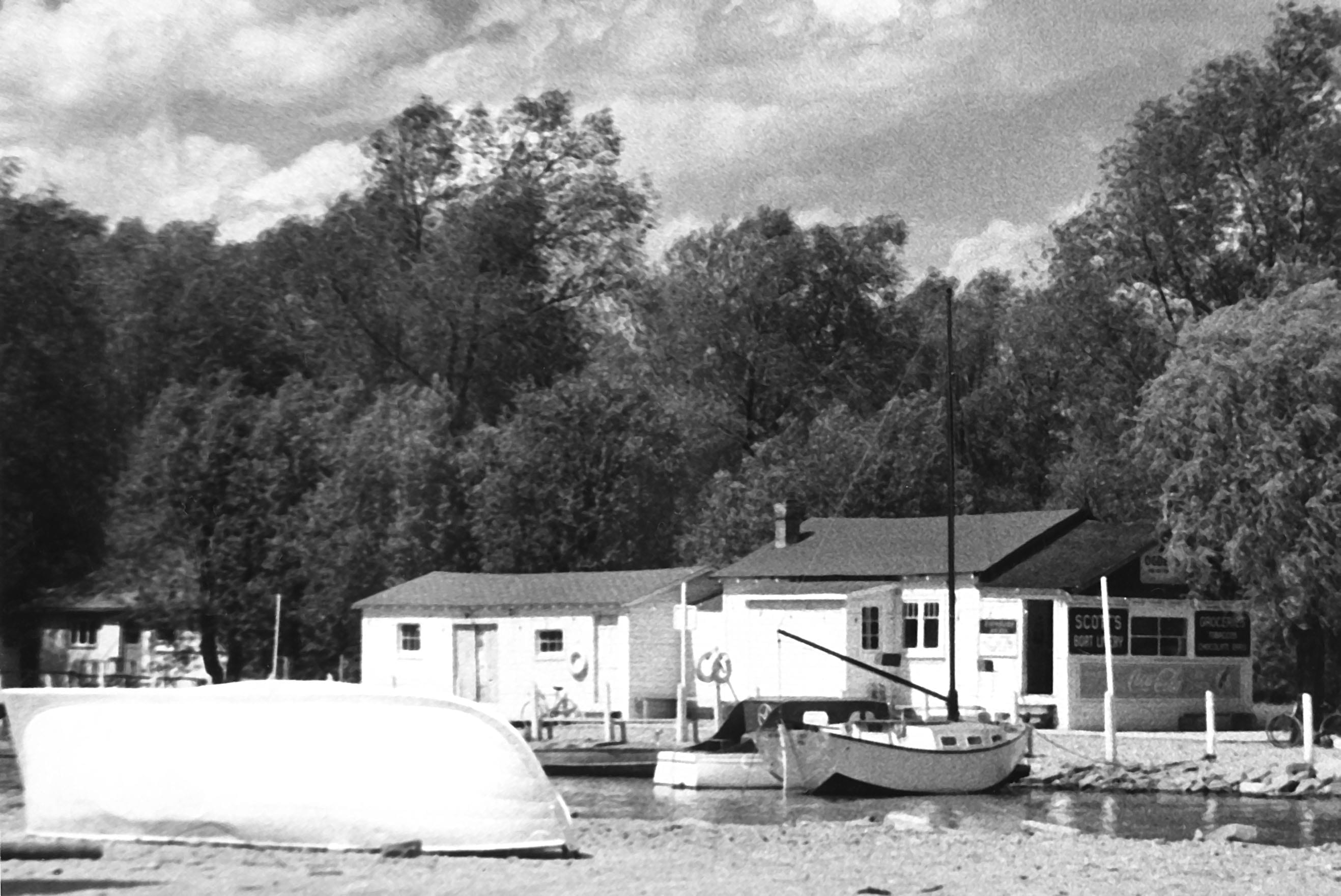
Scott’s Boathouse. Photograph © Bob E. Lansdale. Scanning and digital restoration by Robert C. Lansdale
The Flats. Prior to Hurricane Hazel, Marie Curtis Park was a cottage area known as The Flats. There were houses on the beach but there was public use, as today, opposite the cannon. Also today, there is a building just to the west. In the 1940s and 50s at the same location stood Scotty’s Boathouse where rowboats could be rented.
The Royal Theatre. Going to the movies was a cheap, popular past time prior to the rise of television. Our local cinema was The Royal Theatre. It was possible to see three double bills a week; Monday/Tuesday, Wednesday/Thursday and Friday/Saturday. Sunday movies were not legal until about 1958.
Lacrosse was a popular sport in Long Branch, New Toronto, and Mimico. It was considered our national sport but I never experienced it.
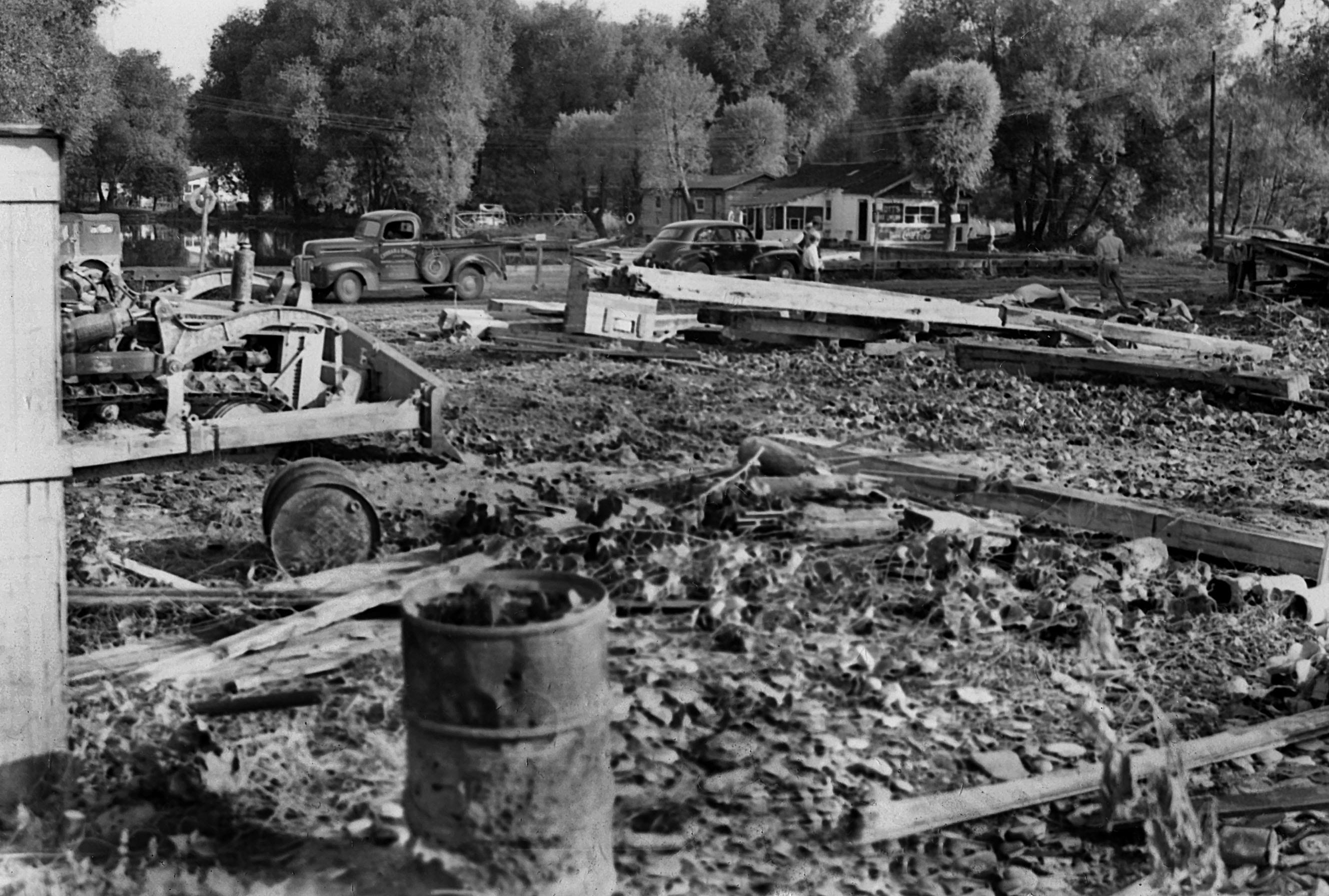
Scott’s Boathouse during removal of cottages at the end of Cottage Country era. Photograph © Bob E. Lansdale. Scanning and digital restoration by
Robert C. Lansdale.
Concerts in the Park. In the 1990s the Long Branch Historical Society presented Concerts in The Park. They were held Sunday nights at the gazebo in Long Branch Park. Many enjoyable entertainers appeared, some on a yearly basis, The Salvation Army band, a Canadian Legion group, a local lady harpist, etc. Perhaps someday they can be revived.
[End of text from Barry Kemp]
Click on the photos to enlarge them
*
Note regarding history of the British empire
Since writing this draft, I’ve spent some years reading about the history of the British empire. I first began to read about this topic because I wanted to learn about the circumstances in which Colonel Samuel Smith lived and worked as a military officer. A typical post about the British empire is entitled:
I also like to keep up to date on the Lakeview development in Mississauga:
Leave a Reply
Want to join the discussion?Feel free to contribute!
In a separate post, I’ve explained the approach that I’ve adopted in writing my draft of a history of Long Branch:
Foreword to a post about the history of Long Branch (Toronto)
Some time back, I posted a link to “History of Long Branch (Toronto) – DRAFT 4” to the Facebook group called “Did You Live In Mimico / New Toronto / Long Branch?” I may have heard about the Facebook group years ago but had not joined the group until recently.
I’ve been gratified to learn that readers at the above-noted Facebook site have shared their appreciation for the draft text, that I’ve put together, and have added great details of their own experiences of Long Branch from years ago. Below, with Jean Earl’s permission, is a recent dialogue at the latter Facebook group:
Jean Earl: Thank you for a very interesting read. During the early 40s I lived at 205 Lake Promenade on the shore side and my in laws (Earl) lived at 203 Lake Promenade and had a boat livery and my grandparents (Childs) lived at 208 Lake Promenade , their backyard looked into the parks property. Along side the road was a deep ditch that ran into Lake Ontario and I spent many a happy day sitting on a large plank of wood spanning the ditch while I pretended that I was sailing to many places. I also remember the dance pavilion and hearing the music and peeking through the wooden slats to see all the people dancing. There was a ball diamond to the north of the pavilion (if memory serves me right) and it was set in a hollow and Park Blvd ran to the north of it and on its slope was were I first tried out my new skis at the age of about 6 or 7. 🙂
Jaan Pill: This is wonderful to read, Jean. Such details are of so much value. I would like to add your overview to a future version of my draft of the History of Long Branch. I would also like to use some of the other great material, that people have shared, at the discussion thread we are now reading. I hadn’t thought about that, until now. Is it okay, Jean, if I publish your text (above) in some form? I wish to also ask readers if I can publish their comments as part of my draft project in future also; I will contact each of them individually, when time permits.
Jean Earl: Thank you Jaan, I’d be happy to have it included. 🙂
Jaan Pill: Thank you Jean; I have added your comment in the Comments section at the end of “History of Long Branch (Toronto) – DRAFT 4” article. I look forward to adding more comments, that people have shared in response to my draft; but first (when time permits) I will ask for permission from each person, so that I can also post their Facebook comments at my website. I am so pleased that we have the opportunity to share so many great stories – from the past and in the present moment – about Long Branch. These are indeed great stories that warrant sharing so that we can hold on to them, and keep them circulating widely.
I agree with Jean about the dance hall (we used to stand near the band (outside the fence) and they’d give us some money to buy the pop or smokes (keep the change ) probably a nickel or so , also the ball field down in the hollow, you could just sit on the hill and watch the games. We enjoyed the water, swimming from one pier to the other. Yes, good times, children could be children (go outside and play), no TV, computers etc. I went to the Long Branch Continuation school, I even remember some teachers names and how we got the rest of the day off when the war was over. Used to swim in the creek as well and catch the small crabs, memories. What a great read, I lived on 33rd st. in a house with lots of trees and a big veranda. Happy times, but short lived.
Also from the Facebook group called “Did You Live In Mimico / New Toronto / Long Branch?”, I’m pleased to add the following comment (with permission from Jo-ann):
Jo-ann Langley: Very interesting, my parents built on Arcadian Circle in the 40s, or according to what I read here, previously called Connaught Circle.
Jaan Hendrik Pill: That dates back to an interesting subdivision, with all the winding roads, set up in 1910.
Jo-ann Langley: You can certainly use my comments and I have a picture of my parents in front of their newly built home on Arcadian circle in 1940s if you can use it.
Jaan Hendrik Pill: Good to read your message Jo-ann. I will add your comments as an additional item in the comments section of the History of Long Branch – DRAFT 4 post. Yes, it would be great to be able to use the photo. [The photo is of Jo-ann Langley’s parents in front of their newly built (early 1940s) house at Arcadian Circle.]
I look forward to posting additional comments from the above-mentioned Facebook group, but first (when time permits: so many things to do) I will contact each person individually and ask for permission to copy their Facebook comments and post them at the webpage you are now reading.
I’m really pleased the information in the 10,000-plus word article is of interest to many readers.
I’m really pleased that people who have lived in the area going back many, many years have filled me in with so many details – including the story of the Island formed by what used to be the eastern and western branches of Etobicoke Creek – and I’m also really pleased that I have the opportunity to share what I’ve been learning from them! We owe many thanks to all of the great people who have shared, and who continue to share, such valuable and much appreciated information with us.
I would love to read more about the other side of Long Branch!Has anything been done? I lived on 23rd Street from 1942-47 and then on Tamarac – 25th Street til 1955.
I remember the cows and field of cabbages on the Ont Hospital Farm from which my mum graduated as a nurse in 1937. (E side of 23rd St was in New Toronto)
I lived on 25th St in the 1960s in an apartment bldg n of Alder Cres.
Where was Tamarac in relation to that area?
Beverly replies:
In the early 50’s Tamarac ended at Alder Cresc. It did not go through to the highway. When it was opened up the field behind the stores, the apartments were built and the name changed from Tamarac to 25th St. My aunt and uncle lived on 27th st on the east side and if they hadnt moved these apts would have been behind them
During WW2, their house was taken over by the military for a higher ranking official and they had to move to the upstairs in her parents home on 26th street and Daisy Ave.
Good to read your message, Beverlie. Yes, I’ve accumulated quite a bit of material about the other side of Long Branch, with help from Bill Rawson of Long Branch Furniture among other people who remember how things were many years ago. Your comment will motivate me to get to work on that important part of Long Branch! But it will likely take a while as I have quite a few projects on the go.
I lived all my life in Long Branch. Born 1947 and basically left in 1971 to attend College. Could talk forever about the Lakeshore. ThankU so much for all this, it is just wonderful. Oh by the way Barbara Durance was my Grade 4 Sweetheart. Sincerely Roger
Hi Roger – could you possibly be the brother of Debbie McCrindle of 31st Street ? I went to school with her – James S. Bell – right across the street from where she lived ???
Hello
My Wife Jeanette attended Shep School in the Long Branch Army Camp
1942 -1954 Do you have any information on this School. She still has
her School Report Cards.
Jeannette Walton adds in a separate message:
My Husband Don resided in GECO Scarborough and also Little Norway behind the Maple Leaf Ball Stadium next to Tip Top Tailors
Yes, I do have some information on Shep School. I will post such information at this website in the future. It will take some time.
A good way to get familiar, with what has been posted to date, is by checking out the posts at this link:
http://preservedstories.com/?s=long+branch+army+camp
An interesting note from a post entitled Norah Shaw has shared with us some great Long Branch Army Camp photos reads:
I looked up SHEP to see if I could find out what it stood for.
S-soldiers
H-housing
E-emergency
P-project
early to mid 1940’s
[End]
I’m really pleased to be learning more about the Shep School, from site visitors who have a direct or indirect connection to it.
Wonderful to read your comment, Roger. Delightful to know about your Grade 4 Sweetheart. There is something about Grade 4 that we all remember.
I am delighted that you and other site visitors find the information that I’ve put together is of interest. I’ll contact you by email; I’m keen to learn more about your Lakeshore memories! What a delightful community; it’s a real pleasure to have the opportunity to work together with long-time residents to put our Long Branch stories together.
A Sept. 4, 2016 Toronto Star article is entitled: “When the Don Valley was cottage country: Author and outdoorsman Charles Sauriol had the perfect location for a Toronto getaway, until the Don Valley Parkway tore through the back garden.”
The story reminds me of a post at the Preserved Stories website:
Toronto and Montreal wiped out their farmsteads
I would also like to bring your attention to a post entitled:
New 3-minute video from Heritage Mississauga features Small Arms Ltd. wartime munitions plant in Lakeview
You may wonder why the article is labelled Draft 4. It’s because I have seldom worked on an article of this length. I figured that, when I got to Draft 4, I should take a break. I knew that the article was at a stage where it likely could not be very much further improved, through any kind of tinkering. In time, I’ll figure out what the next steps are, for this article and for other articles that I have in mind regarding Long Branch and related topics.
I am pleased that many people have found the Draft 4 version of the article of value. I am pleased that I can help out, in a small way, in documenting stories related to local history. This is very much an interactive, collaborative, and cooperative process. We have much to learn from each other. I owe thanks to each person who has helped me, and/or is continuing to help me, and/or will help me in the future to acquire and document information.
I lived in Long Branch for about 15 years my address was 425 Lake Prominade we call it
we called it Lake Prom .We all went to school in long branch after 1954 we had to move.
If you remember there was only one black boy who went to that school the grade 8
teacher mrs Green wood make fun off him he was great guy his name was Tinker Ash he went on to work for Etobicoke township until he retired .B
I much appreciate you sharing your story, Bruce. I am pleased that your fellow student Tinker Ash is remembered as a great guy. I’m pleased to know of his life-long work with Etobicoke township.
A treat to read Barry Kemp’s reminiscences about caddying at the Toronto Golf Club. I pushed golf carts there between 1953 and 1958. I recall when they boosted the rates in the summer of ’54, B caddies got $1, an A $1.50, and AAs a whopping $2. The year before it was $1 for an A caddy and $1.25 for an AA. We were still underpaid when you saw what other courses gave their caddies, And for some strange reason, “tipping” was a no-no. And these were Toronto’s so-called business and social elite. Talk about tight wads. But they taught us a lesson; always be thrifty. And yes, there were a few members who would request a B caddy. There were a few hardy girl caddies, the Kellys from Alderwood I remember well; swell young ladies who endured the give-and-take of the caddy yard. The Walsh family, Peter, Jimmy, and Anne were also hard-workers, sometimes doing three loops a day when most of us quit after two. A loop (18 holes) would usually take about three hours. Jimmy was later killed in Vietnam serving with the U.S. Army.
We all hated early Saturday morning caddy lessons, but all were expected to attend. We had caddy numbers, and those numbers rotated on a daily basis to ensure that all would have an equal opportunity for early loops. In the summer of ’54, the years of the long overdue fee raise, Gary Yates from the Army Camp was awarded AA1. I was AA10, having been “promoted” two weeks after Yates. You could write a book about the tales and exploits of kids in that caddy yard, as they waited for loops, all good fun. How I wish I could go back in a time capsule to those times with those fellows and gals.
It’s most interesting to read your recollections, Garry. I’m pleased that Barry Kemp got the ball rolling, with his memories of caddying.
I did my own carrying at the Marlborough Golf Club in Cartierville, Quebec on the Island of Montreal. We’ve had many discussions, at this website, about experiences that caddies remember from the latter course, from the 1940s and 1950s.
I still remember some of the stories, from the caddy shack at the Marlborough Golf Club, from these many years ago.
Hi Jaan,
I’m puzzled about the Applewood Creek photo, the watercourse that’s almost on the Etobicoke Mississauga border. Is that the creek that flows just west of where the Small Arms stood, and up through the Lakeview Golf Course? That’s the one we played along as kids. Our kitchen window in the Staff House overlooked it. I referred to it earlier as the Little Etobicoke Creek, but I realize now that’s too far east. There’s a sign on The Dundas Highway, just east of Dixie Rd, with that name, but it must be the Etobicoke Creek. My mistake. I don’t know why the Etobicoke Creek is the “Little Etobicoke” when it flows under the Dundas Highway, or at what point it becomes the Etobicoke Creek. I must track the course of the Applewood Creek. Again, I’m hung up on semantics. As kids, Applewood Creek was just, “the creek.” I wonder if its source was somewhere in those huge orchards that used to be in the Dixie area, or up in Burmanthorpe area, or even farther, where the community of Malton used to be, near the airport. We seldom wandered beyond the QEW.
On a rather sour note, the Army Camp dumped its raw sewage directly from a large pipe into the Applewood Creek, just across from the south east corner of the Camp. Hardly pristine, but those were the times, the war years, and the decade that followed. We always gave that spot a wide birth. The mouth of the creek was quite a marshy area, lots of cat fish near the lake. When you got there hiking east along the lake’s shore, you could see across an inlet, too deep to wade, that formed what I would call a lagoon. Between that lagoon and the lake was the long spit on land with the cottages, lived in year round, that met their demise with Hurricane Hazel.
I was wondering, Garry, about your reference to “Little Etobicoke Creek.” I will make the correction, in your previous reference to it.
Work is currently underway (February 2017) at Applewood Creek near Lakeshore Blvd. East. The work may have a connection with the Lakeview Waterfront Connection Project, concerning which extensive information is available at this website.
That’s interesting, about the raw sewage outlet. That’s an interesting detail, from the past, that is valuable to know about.
Jaan, I see a minor comment about a pavilion and dance hall located on the lake at the point where the river turns right into what was known as the lagoon. The building was known to me as “Mrs. Oates Pavilion”. In 1946 my teenage cousins came to stay with us and they would take my father’s rowboat out to the first buoy where they would tie up and go swimming. If I behaved, they would take me to Mrs Oates Pavilion for Ice Cream or, occasionally to Scott’s boathouse on the east side of the creek mouth, also for Ice Cream. Ice Cream guaranteed that my lips were sealed when my father asked the girls where we went. I have, in recent years seen a wide angle (probably composite) photo of the pavilion. Several very old large cars are parked in front. The photo is not dated but the cars pre-date 1935.
David, it’s wonderful to read your account, of your good times at the bend in the river. It’s so interesting, for me, to picture the bend in the river and all of the great activities that were happening there.
I’m reminded, as well, of a message, at this website, from a person who was writing from somewhere in Western Canada. I don’t recall where the message is, but I know it’s somewhere, at one of my posts from years ago.
What the writer said was that his family spent a year or two living at the mouth of Etobicoke Creek around the early 1950s. He said he was living there for just a short time, and yet the times out on the water, and elsewhere in the vicinity were, in his store of memories, among the happiest times of his life.
He mentioned, as I recall (and I will be interested to see how accurate, or inaccurate, my recollection of the message may be), that sometimes the kids would wander off and the parents would be concerned.
Hi Jaan,
I just read this site with interest the above recollections and recognized Jo-ann Langley who lived three houses from our house on Arcadian Circle and Roger Mc Crindle’s sister Debbie who sang at my wedding.Long Branch will always be with me where ever I live. It was great to read other peoples memories of this very special place. Thank you for your efforts on preserving this history and other articles such as the Long Branch Hotel Fire which you interviewed me on.
Hi John,
Wonderful to read your message. Long Branch will, as you so aptly note, always be with us wherever we live. I much enjoyed doing the interviews with you some time back about the Long Branch Hotel Fire. I will be transcribing interviews with you and many other people, in the coming year, and will post articles based on them.
You may be interested to know of the following Wikiwand resource. My thanks to Norah Shaw, who over the years has shared many engaging stories related to Long Branch, for informing me of this web page; in particular, some of the links may be of interest:
Long Branch, Toronto
This Wikiwand resource (which I assume – albeit assumptions are subject to error – may have some relation to Wikipedia) correctly notes that the Long Branch Hotel burned down in 1958.
A large number of archival photos from southern Etobicoke have been recently donated to the Toronto Archives.
Jack Marshall took a lot of photos in the Lakeshore area decades ago. His studio was in the east end of Long Branch. He did assignments for the Toronto Star, the Globe and Mail, and the Lakeshore Advertiser.
Marshall’s negatives have been recently donated to the Toronto Archives. Some of his archival material has also been donated to the University of Toronto. The large batch of photos from southern Etobicoke would be of interest to many people. I was pleased to learn, in March 2021, of the whereabouts of the photos.
Bob Lansdale, the original contact that enabled me to learn about the photos, has previously contributed valuable information to this website. Robert Lansdale, who’s the son of Bob Lansdale, has also shared extensive information and many photos at this website. We owe many thanks to each person who has shared information with us since this website was launched a decade ago.
Thank you for this fascinating history of Long Branch. I grew up there, at 23 Elder Avenue, and have been looking for information on the development of homes north of Lake Shore Blvd. The oldest house in Long Branch was on the same block as our home, but on the Daisy Avenue side of the block.
I’m really pleased you enjoyed the overview. I’ve often thought about the fact that north of Lake Shore Blvd. West and south of Lake Shore Blvd. West are each a part of Long Branch and also each with its own history.
The Long Branch Library has a section devoted to local history. I recall reading an interesting study, available in the local history section at the library, about the planning history of the area to the north of Lake Shore.
I’m really pleased that 28 Daisy Avenue was designated under the Ontario Heritage Act with support from large numbers of area residents:
Update regarding 28 Daisy Avenue: Notice of passing of bylaw
At the above-noted post I have a passage that I think about from time to time:
I especially like the information that there was a time in the 1910s and later where you could see clear to Lake Ontario from houses in the vicinity of 28 Daisy Avenue and it was not unusual for a horse or cow tro wander over to a house and have a look.
Bill Rawson, who owns the used furniture store on Lake Shore Blvd. West across from the Long Branch Library (the store is closed while the results of a fire in an adjoining property are being addressed) has told me of the time his younger brother, then a baby, was sleeping on the porch of their house, which was in that part of Long Branch. A horse came up to the house and stuck its nose into the baby carriage to have a close look at the baby brother.
Deputy Mayor Doug Holyday, who grew up in Long Branch, has spoken of how cows would come up to the windows of a house north of 28 Daisy Avenue that his grandfather bought in 1919.
The above-noted text is from July 3, 2013. Bill Rawson’s used furniture store is now long gone. I’m really pleased I was able to arrange for Bill to take me on a tour some years ago of Long Branch, north and south of Lake Shore Blvd. West. I drove in my car, he sat next to me and spoke of the local history as we were driving.
I’m looking forward (in years ahead: I have many writing projects on my plate) to working with the audio recording and video recording that documented that tour of the area.
Your comment has prompted me to refresh my memory about all of the things I’ve learned from talking with Bill Rawson over the years. I got to know him in the first place in the course of a Jane’s Walk that I was involved in leading in Long Branch some years ago.
I now live in Stratford, Ontario. I much enjoy visiting Long Branch when I am in Toronto. It’s a lovely community. Among other things I’m highly impressed with the work of the Long Branch Neighbourhood Association, including its efforts on behalf of the tree canopy and also its work in development and implementation of the Long Branch Character Guidelines.