Etobicoke-Lakeshore MPP Peter Milczyn’s May 5, 2018 Jane’s Walk (starts 10:30 am at Long Branch Ave. & Lake Shore) now posted at Jane’s Walk website & Facebook page
The May 5, 2018 walk in Long Branch led by MPP Peter Milczyn has now been posted to the Jane’s Walk website and Facebook page
Click here to access the walk details on Facebook >

Long Branch Hotel map. Drawing courtesy of Bill Rawson, May 2013. Bill Rawson for many years had a used furniture store, Long Branch Furniture, on Lake Shore Blvd. West. He has shared many great stories about Long Branch with us going back to the years before, during, and after the Second World War.
The text for the walk, at the Jane’s Walk website, reads:
Evolution of Long Branch Park (Starting 1884)
Led by Etobicoke-Lakeshore MPP Peter Milczyn
10:30am – 12:00pm | Southwest corner of Long Branch Ave. and Lake Shore Blvd. West in Long Branch
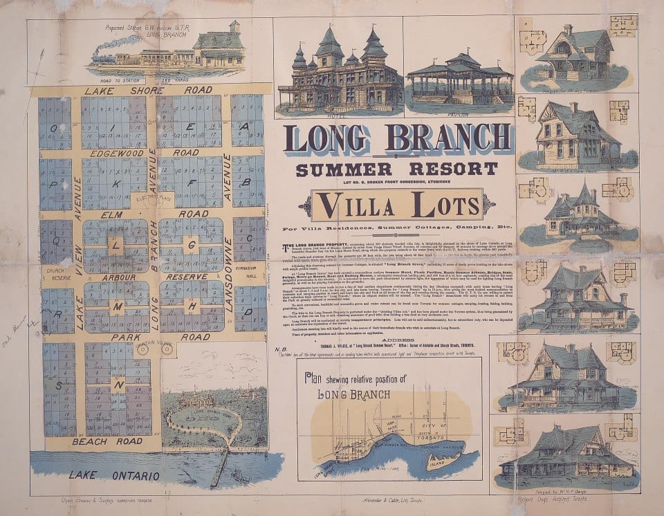
Poster of Long Branch Park development. The poster is entitled: “Long Branch Summer Resort lot no. 9, broken front concession, Etobicoke villa lots for villa residence, summer cottages, camping, etc.” Details on how to order a copy of the poster are available at a Toronto Public Library webpage entitled: “Collection Reproduction and Digitization on Demand.” The current names of streets in the area can be accessed at an archival document: Long Branch Street names – May 13, 1935. Click on image to enlarge it; click again to enlarge it further.
Starting at Lake Shore, Peter Milczyn will lead us south along Long Branch Ave. toward the Lake Ontario shoreline. We will traverse the site of Long Branch Park, serving summer visitors arriving by boat from Toronto starting in 1884. Along the way, we will pass by many heritage houses from a previous horse-and-buggy era, and will encounter the neighbourhood’s constantly evolving built form. Join Peter Milczyn on this walk to understand the transformation of this late-1800s Cottage Country summer resort to a pedestrian friendly neighbourhood at the heart of the Village of Long Branch. This Walk will end where it began.
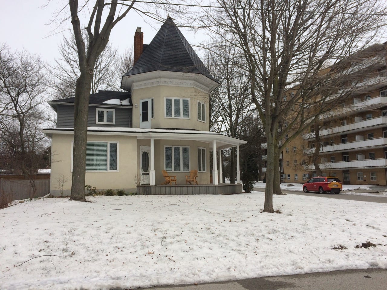
The Long Branch Hotel (which burned down in 1958) was located near the northeast corner of Long Branch Ave. and Lake Promenade where an apartment building, at the right in the photo, now stands. Jaan Pill photo
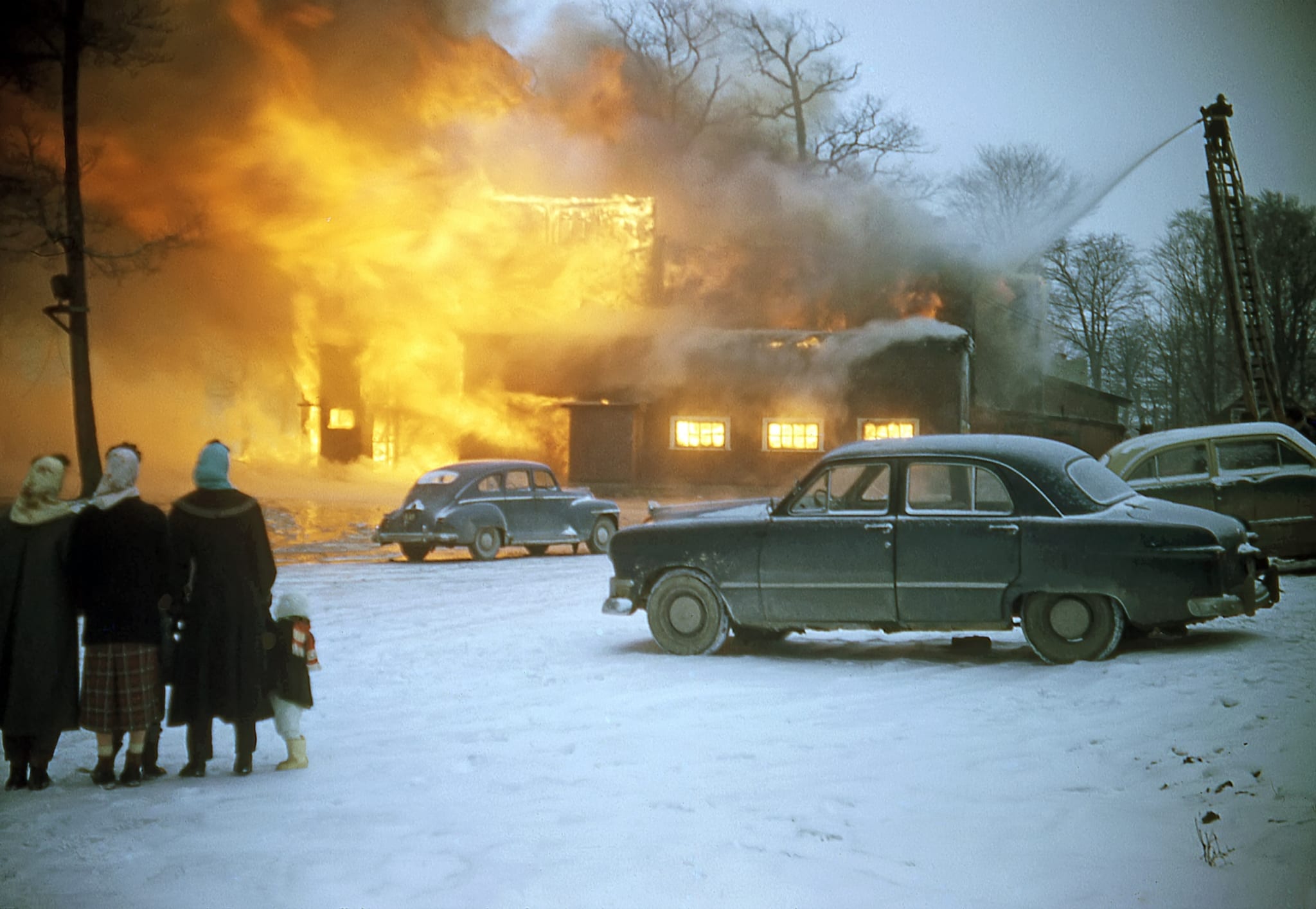
Slide 5 from a previous post. We owe thanks to Robert Lansdale for Photoshop colour correction of this image. Alex Stewart photo. Click on the photo to enlarge it; click again to enlarge it further.
[End]
Route for Minister Milczyn’s May 5, 2018 Jane’s Walk
The following post at the Preserved Stories website outlines the route:
Here’s a brief description:
We start at the southwest corner of Long Branch Ave. and Lake Shore Blvd. West.
We travel south to the corner of Long Branch Ave. and Lake Promenade.
From there we travel east along Lake Promenade to a point about half-way between Long Branch Ave. and Thirty First St.
At the half-way point, we walk north through a parking lot heading to Park Blvd.

A map from the Long Branch Historical Society shows the shoreline of Lake Ontario as it existed during the years before the Long Branch Hotel burned down.
But just before that, we have a look at Long Branch Park, in its current, much smaller configuration, namely the outcropping of land, into Lake Ontario, that was created through infill after the Long Branch Hotel burned down in 1958.
Lake Promenade terminated at Long Branch Ave. and resumed slightly west of Thirty First St.
An interesting feature of this area is that, during the original Long Branch Park era, Lake Promenade stopped at Long Branch Ave. and then continued again at a point just to the west of Thirty First St. (please see Bill Rawson’s map, at the top of the page you are now reading).
In between the two streets, there was a beach, and a couple of piers; at one of the piers (maybe both; I do not have information regarding this point), summer vacationers (seeking relaxation in a bucolic lakeside setting) from Toronto would have disembarked starting in the late 1880s. The resort itself was a gated community.

Screenshot of online City of Toronto Heritage Register map, accessed April 18, 2018. The map indicates that many of the houses on the May 5, 2018 Long Branch Jane’s Walk route, discussed at the post you are now reading, are listed as heritage properties. If you access the map (at the link referred to earlier in this caption) and zoom into the above-noted section of it, you can locate the addresses of each of the properties.
Continuing on our route, we go east a short ways along Park Blvd. until we get to Thirty First St.
We walk north along Thirty First St. to Lake Shore Blvd. West.
At Lake Shore Blvd. West we walk west until we are at the southeast corner of Long Branch Ave. and Lake Shore Blvd. West.
Click on images to enlarge them; click again to enlarge them further
A related post is entitled:
Click here for previous posts about Jane’s Walks >
History of Lake Promenade
A noteworthy feature (which previous Jane’s Walk participants have found it remarkable to discover) of Lake Promenade was that in years past it extended westward almost to Applewood Creek, where the Mississauga-Toronto border (that is, the portion of it that extends along the Lake Ontario shoreline) is located:
I have highlighted the history of the mouth of Etobicoke Creek at a recent post entitled:
Leave a Reply
Want to join the discussion?Feel free to contribute!