Beware the waterfront trail to the west of the Humber River; many collisions have occurred along the trail

Please take care and be fully alert when driving in Toronto during the reunion weekend. Please note the fine for distracted driving starts at $490. The penalties go up to a maximum $1K fine and three demerit points for drivers who text, email or talk on handheld phone. Jaan Pill photo
In an earlier post, I’ve noted that driving in Toronto requires your full attention, and the fines for distracted driving are substantial.
The caption to the photo on the right highlights the story.
In the current post, I want to bring your attention to some features of the Humber River.
1) Humber River runs close by Old Mill Toronto
I will be leading a Humber River walk starting at 10:30 am on Sunday, Oct. 18, 2015. The walk will start at Old Mill Toronto, at a point close to the bridge that crosses over the Humber River.
The walk will take half an hour, as we need to arrive at the Old Mill Restaurant at 11:00 am in time for Brunch.
If you plan to join us for Brunch (it will cost you $35) as part of the MCHS ’60s Reunion, please let me know by Oct. 11, 2015 as we need to know how many grads will be attending.
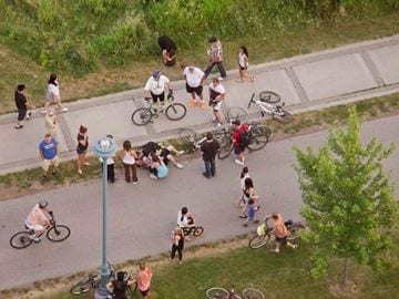
Palace Place resident Robin Clay shot this photograph from his window July 27 around 8:30 p.m. after two cyclists collided on the trail. Paramedics transported one cyclist to hospital. Many Humber Bay Shores and Mimico residents charge cyclist collisions happen routinely on the trail. They are asking the city to implement safety measures, such as signs or speed humps, to slow some cyclists down. Source: Aug. 6, 2015 insidetoronto.com article cited at the post you are now reading
2) Beware the waterfront trail east and west of Humber River, along the Lake Ontario shoreline
In 1615, 400 years ago, the shoreline of Lake Ontario was not as far to the south of Old Mill Toronto as it is now. The current version of the waterfront is an area that warrants close attention.
The trail in this area is a source of extreme danger to pedestrians, cyclists, and all other creatures (dogs, by way of example) who venture out that way. I have had a close call some time ago, in my role as a pedestrian out to take some photos at Humber Bay Shores, which is a reason why I have an interest in the topic.
To state the matter succinctly, the current configuration of the trail is a total mess from a traffic management point of view. An article (and photo) from the insidetoronto.com sums it up well.
An Aug. 6, 2015 article at insidetoronto.com is entitled:
Cyclists’ disregard for safety on Humber Bay Shores trail ‘frightening’ say residents:
Dedicated paths, traffic calming measures sought by pedestrians using Martin Goodman Trail
If you value your life, do not venture forth along the trail through Humber Bay Shores or by Amos Waites Park unless you have a strong grasp of what you are getting into.
At Amos Waites Park in Mimico, you have a kids playground located next to a trail where cyclists race around blind corners from either east or west. The situation serves as a metaphor for a particular configuration of historic forces which can be characterized as: “Build it. Don’t give it too much thought. Ignore local input. Don’t listen. Who cares about the details. Who cares about the residents, and the visitors.”
On the other hand the trail that runs through Marie Curtis Park, still further to the west, is laid out in a way that takes the safety and smooth flow of cyclists, runners, and walkers closely into account.
I go running along that part of the trail regularly from Long Branch into Mississauga and in 20 years have never seen an accident, except for one occasion where two cyclists collided at a point along the trail where the view was obstructed by some foliage. After the accident, authorities removed the foliage and things have been fine ever since to my knowledge. I have not heard reports of much in the way of accidents along that part of the trail; please contact me in the event that you have contrary information.
3) The physiography of the Humber River near Old Mill Toronto is of strong interest to one or two of us
I am absolutely fascinated by a book called The Physiography of Southern Ontario (1984).
If you drive or walk along Bloor Street West from the west, you go down a large hill that takes you down to a bridge that crosses the Humber River. When you approach the bridge from the east, you also travel down a significant incline.
I have often wondered: “How was the valley formed, at this point in the Humber River? What forces were at play, and over what scale of time?”
The above-noted book offers some clues and I await an overview from Scott Munro, who taught geography at the University of Toronto for many years, describing the processes that were at play, over the past 10,000 years and more, that gave rise to the slope of the land in this area close to Old Mill Toronto.
Updates
See comment below, from Scott Munro concerning the physiography of the Humber River.
A more recent post about related topics is entitled:
Scott Munro (MCHS ’63) has added a comment regarding the physiography of the Humber River
A related post is entitled: Étienne Brûlé / First Nations event took place on Sept. 13, 2015 at 222 Riverdale Drive
Scott Munro (MCHS ’63) is a member of the MCHS Event Committee. He is an avid bagpiper, who will play “Amazing Grace” just before we begin the Humber Dinner Buffet at 7:30 pm on Oct. 17, 2015 at Old Mill Toronto. In a recent email message, he writes:
Hi Jaan – This relates to item 3) in your blog. Part of what you write there relates to the location of the Lake Iroquois shoreline, on which Casa Loma is situated further east. Also, the Humber River underfits its current valley which was likely a spillway for large amounts of meltwater produced by the decaying ice cover of the Laurentide Ice Sheet, amounts that probably did not occur again until the arrival of Hurricane Hazel or previous unrecorded storms.
Lake Iroquois drained out through the Mohawk Valley of New York State to the Hudson, then shrank into the current space of Lake Ontario, after which time the outflow was redirected down the St. Lawrence River because by then the ice sheet no longer blocked the St. Lawrence Valley. Best – Scott