Tim Hewlings has shared two great maps highlighting the history of Bois Franc – a topic Graeme Decarie had asked about
Tim Hewlings writes:
“Here are a couple of maps of the area that might help the discussion. Maybe you can upload them.”

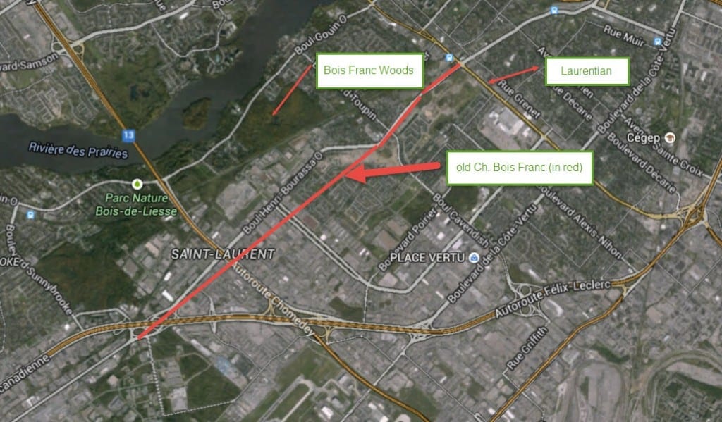
Bois Franc today. We owe thanks to Tim Hewlings (MCHS '63) for sending along this map. The source is Google Earth.

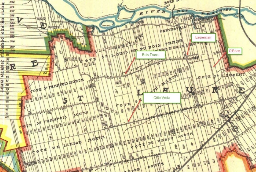
1907 map. The early map, Tim Hewlings notes, is from: A. R. Pinsoneault, Atlas of the Island and city of Montreal and Ile Bizard, s. l., The Atlas Publishing Co., vers 1907 found on the BANQ website. The map includes a view of where Raimbault Creek used to run. We've added the map to previous posts that deal with the creek.
You can click on each image to enlarge it.
The discussion about Bois Franc is at these posts, to which I’ve now added the maps:
Graeme Decarie has a question about the old Bois Franc. Do you know the answer?
We’ve had many comments in response to Graeme Decarie’s Bois Franc question
I much appreciate the work Tim Hewlings has done in locating these maps. Having a graphic reference of this nature adds so much of value to our understanding of the discussion.

I’d like to know where the red arrows and green boxes found on these maps came from. When I looked at the 1907 map 10 days ago, those arrows and boxes weren’t there. The Google Earth map has a box marked “Bois Franc Woods”. Those woods may have been part of the Bois Franc woods many years ago but today they would be called the Saraguay Woods or the Bois-de-Saraguay Nature Park
2 points about the 1907 map:
(1) Although the green box with a red arrow indicates “Bois Franc”, the name on the map is “Cote St Louis Road”
(2) The area between this road and the river to the north is named by the map as “Cote St Louis OR du Bois Franc”.
The notations were done with a great piece of software called Snagit, by a company called Techsmith. You can grab anything on screen with it, annotate it and store it or export it to other programs like Word. I use it all the time for preparing reports and presentations.
BTW, looking at the map notation of Cote St. Louis or du Bois Franc, I figured that Cote St. Louis Road eventually became Chemin Bois Franc, hence my notation. (I couldn’t find anything more recent on the BANQ website.) In any case, if you compare the two maps they appear to be located in the same place.
I agree with you about the Saraguay Nature Park, but I’d be willing to bet that 100 years ago it was much larger. I think this was the area that Graeme Decarie was talking about hiking in with his father.
My father once told me that in the ’20s and ’30s, Cartierville was out in the country. People from NDG and Westmount used to have their summer cottages on the Back River.
Thanks for letting me know about Snagit.
I figure you’re on the money as far as Cote St. Louis Road later becoming Chemin Bois Franc. Only, the notation in the green box says “Bois Franc”, not “Bois Franc Road” or “Chemin Bois Franc”. I don’t know if it’s possible using Snagit, but if there was to be a notation about where “Bois Franc” was back in 1907, I would try to make the notation indicate that “Bois Franc” covered the entire area from Cote St Louis Road to the river, the eastern and western boundaries being where the thick red lines are – except that it’s unclear from the map where the boundary between this area and “Cote St. Laurent” was. This area is referred to on the map as Cote St Louis OR du Bois Franc. Weird that a professional cartographer would use the word “OR” like this but there it is. Unfortunately, it’s also unclear from the map how far east Cartierville extended –whether it extended as far as Raimbault Creek or even beyond, past O’Brien.
The way I read the map, “Bois Franc” covered a very big wooded area, which included Cartierville. It also included the woods now known as Bois de Saraguay Nature Park.
The house I grew up in was close but not on the Back River. It was built in the ’20s. It was a summer house. My father bought it in the ’40s and winterized it. There actually wasn’t that many summer cottages along the river in Cartierville. The only one that comes to mind was located next to Belmont Park for years, even before the Park was built in 1923. This old summer house belonged to the head of the Protestant School Board of Greater Montreal.
I generally stay away from Wikipedia. However, the following item from a Wikipedia entry about Quebec Autoroute 13 provides information that may help to round out the discussion:
“Boulevard Pitfield derives its name from the origin of the actual route. In the 1920s, the actual route was a Polo Pony Trail leading from the various estates of the Saraguay Village residents to their Polo Fields, now where the area of St. Laurent Blvd and Bois Franc merge. In the late 1930s the path became an unpaved local road. Over the next several decades Saraguay Farms, owned by Mrs. W.C. Pitfield, was paid to clear the road in the winter by the municipality of St. Laurent. The road was developed into a two-lane highway in the 1960s.”