1909 postcard on the radials through Long Branch (Jane Fairburn); 1909 Middle Road Bridge (Dave Cook)
Along the Shore (2013)
Jane Fairburn, author of Along the Shore, focusing on the waterfront communities of Toronto, has posted a vintage postcard on the radials through Long Branch on the Along the Shore Facebook page.
Here’s the text accompanying the photo, on Jane Fairburn’s Facebook page:
“In the late nineteenth century, as the middle class emerged with time and money to spare, so did a leisure and tourism industry that was concentrated along the lakefront, from east to west. These areas, including Long Branch Park near Etobicoke Creek, were made even more popular and accessible with the appearance of mass transit: the electric streetcar, and in the Lakeshore and Scarborough shore areas, their country cousin, the radial.
“Another popular area, noted by the Toronto Railway Company in a brochure entitled ‘Toronto as Seen from the Streetcars,’ was Mimico Creek: ‘A short distance west is another little river, too small for boating, but just the thing for bathing; it has a fine sandy bottom and is deep enough for a swim without fear of drowning’ — if you have a chance, get out in the unseasonably warm weather and experience the rejuvenated mouth of Mimico Creek today!
“Lakeshore and Long Branch Car – Conductor on side – Near lake – 1909
“Chuckman’s Other Collection (Toronto Post Cards) Volume 02”
1909 Middle Road Bridge
The reference to 1909 brings to mind the Middle Road Bridge – discussed in a previous blog post – which crosses Etobicoke Creek between Mississauga and Etobicoke north of the Queen Elizabeth Way. As you walk east across the bridge you arrive at Sherway Gardens.
Dave Cook describes the bridge in Chapter 12, A footbridge and the QEW, in Apple Blossoms and satellite dishes: Celebrating the golden jubilee of Applewood Acres (2004):
“According to the Ministry of Transportation Ontario, the need for the QEW [Queen Elizabeth Way] arose after the Toronto-Hamilton Highway (built in November 1917), and later known as Highway 2, became overloaded and a new route had to be considered. The Dundas (Hwy.5) was also at its capacity. As a result, planning began for the Middle Road, which became the Queen Elizabeth Highway.
“At this point it should be noted that the Queen Elizabeth Highway did not follow along the original alignment of the Middle Road. The best example of the Middle Road can be seen at the eastern limit of Sherway Drive. The bridge that spans the Etobicoke Creek is in fact the historic Middle Road Bridge. It was also nicknamed ‘White Bridge’.

View toward Middle Road Bridge looking east from eastern limit of Sherway Drive in Mississauga. In the background on the right can be seen condos under construction near Sherway Gardens across Etobicoke Creek in Etobicoke. Jaan Pill photo: December 2012
“This particular bridge stands out above all others as it was the first of its kind ever built in Canada, and only the second of its kind ever built in North America. The bridge was designed in 1909 by Frank Barber and C.W. Young. It’s a concrete truss or tied arch bridge and was celebrated for its light weight and strength. The bridge was tested on opening day when 40 cattle were herded across its span. On October 14, 1986, I had the pleasure of co-officiating the ceremony with Etobicoke Mayor, Dennis Flynn, that designated this bridge as a heritage structure. This bridge became the only structure in Ontario to be designated and renovated jointly by two municipalities. Applewood Acres resident and artist, Leonard Crump, who lives on Courtland Crescent, presented me with one of his outstanding drawings of this bridge that he did in 1978, prior to the restoration.
“The QEW was designed as a four-lane divided highway having a median strip which would vary from three feet to 10 feet in width with the remaining less traveled sections as undivided roadway. It wasn’t until 1940 that a 4-mile (6.4 km) section from the Humber River to then Highway 27 (now the 427 Highway) was opened.”
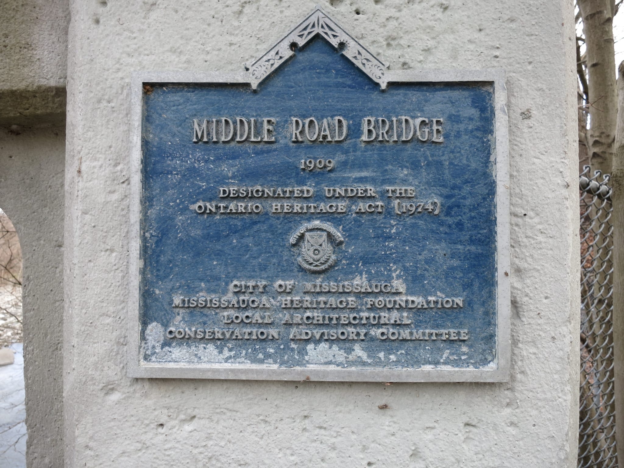
Plaque on Mississauga side of bridge: Middle Road Bridge (1909). Designated under the Ontario Heritage Act (1974). City of Mississauga. Mississauga Heritage Foundation. Local Architectural Conservation Advisory Committee. Jaan Pill photo

Plaque on Etobicoke side of bridge: Middle Road Bridge (1909). Designated under the Ontario Heritage Act. City of Etobicoke. Etobicoke Historical Board. Local Architectural Conservation Advisory Committee. Jaan Pill photo

View looking west toward Mississauga. Jaan Pill photo

View looking east toward Etobicoke. Jaan Pill photo

View looking south. Jaan Pill photo

View looking north. Jaan Pill photo

East side of Etobicoke Creek, north of Middle Road Bridge. It’s a delight to observe that the Etobicoke Creek flood plain serves as a beaver habitat. Jaan Pill photo
During the 1960’s this bridge was a short cut to get from our house in Etobicoke to Savettes at Dixie Plaza (when Dixie Plaza was still alive & kicking). I remember that well. We’d go there to buy clothes and various items (like mood rings and Pet Rocks) before Square One and Sherway came on the scene after 1971. The Middle Road bridge was probably closed off once the Sherway areas was redeveloped and the new onramp to QEW added.
Does anyone know when the bridge was closed to automobile traffic?
I have checked; here is what I have learned:
1) First response reads:
My guess is in the early 1950s (if not earlier). That is when the old Queensway Hospital was built. The bridge is behind it.
https://trilliumhealthpartners.ca/aboutus/Pages/History-The-Queensway-General-Hospital.aspx
2) Second response reads:
I don’t have a definite answer either. There’s a lot of information about the bridge on-line, but nothing about when it closed. I also looked in past issues of the Toronto Star and Globe & Mail and found nothing. The is a book on Alderwood history and it talks about the creek a few times and even has a photo of it (referred to as “the white bridge”), but the details are vague. There is a reference in the book to Hurricane Hazel devastating the creek and the “old swimming hole” disappearing. Perhaps the hurricane damaged the bridge foundation, but that’s just conjecture on my part.
I much appreciate knowing about the Middle Road Bridge as it was in previous years. It’s truly a revelation to know that driving across the MIddle Road Bridge in the 1960s was a faster way to get to Savettes (where Dixie Mall is now located) before Sherway Gardens was put in.
These stories bring back a lot of memories for me. I lived in Applewood Acres (Westacres) between 1954 and 1973 and I remember riding my bike to “White Bridge” many times. After riding there with a friend one day in the late ’50s, we noticed a treasure trove of old pop bottles scattered around in the bush beside the bridge. Somehow we managed to convince my father to drive us out there one spring evening to collect as many bottles as we could scavenge. I remember filling up the trunk of his ’56 Chevy with all these muddy bottles and my father getting stuck in the mud. Needless to say, he wasn’t too pleased and made it quite clear that he wouldn’t be driving us back to the “Bridge” again. After cleaning up the bottles, my friend and I cashed them in at one of the local grocery stores in Applewood Shopping Centre and were “rich” until we visited the local candy store! (I think pop bottles were worth about 2 cents each back then).
That is an awesome story Doug! Such a memory, especially when it is shared, has such tremendous value.