The stream that used to run through Cartierville in Montreal was called Raimbault Creek
Tim Hewlings of Montreal has confirmed that the creek in Cartierville, that I discussed in a previous post, a post that has been widely read, and that has been described as “very evocative” – it’s great to get that kind of feedback – by a recent site visitor, was called Raimbault Creek.
You can click on the image to enlarge it. Click again to enlarge it further. Use the “back” button on your browser to return to the page you are now reading.
The creek now runs entirely underground.
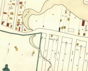
Tim Hewlings has also shared with us an extract of a 1949 map of Cartierville that he found. This is a wonderful archival document. I much appreciate the opportunity to share the section from the map.

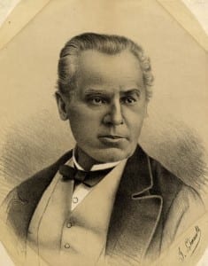
George E. Cartier, 1871. 1873, Picture - Public Domain. Source: Digital Archive, Toronto Public Library website
Cartierville named after George-Etienne Cartier

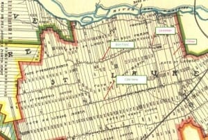
1907 map, which includes an image of Raimbault Creek as it existed at the time. The early map, Tim Hewlings (MCHS '63) notes, is from: A. R. Pinsoneault, Atlas of the Island and city of Montreal and Ile Bizard, s. l., The Atlas Publishing Co., vers 1907 found on the BANQ website. click on the map to enlarge it.
I’m also pleased to say that I’ve recently confirmed, by talking with Grade 8 students who have been doing a history project, that Cartierville is named after George-Etienne Cartier (1814-1873).
A 1983 review of two books about Cartier describes him as “an elusive figure in Canadian history.” Among other topics the review, which I found highly engaging, highlights the history of the Sulpicians, who among other things were involved in the colonization of the land on the north shore of the island of Montreal that became known as Cartierville.
I’ve recently been reading George-Etienne Cartier: Montreal Bourgeois (1981), a book that is regarded favourably in the above-noted review. The book adds to my appreciation of William Faulkner’s observation that “The past is never dead. It’s not even past.”
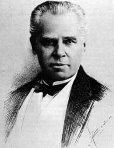
Cartier’s hair style
Sample quote (p. 38) from the above-mentioned study:
“Cartier’s rising income allowed him to indulge his inherited bourgeois tastes. In its simplest form this meant attention to comfort, food, furnaces, carpets, and gas-lighting. However, Montrealers of Cartier’s rank sought more than storm windows, a full stomach, and a large house. The perception of Cartier by English Canadians as an unaggressive French-Canadian bon vivant obscured his serious social ambitions that are attested to by his wine cellar, servants, library, and hotel bills, by his stable, fruit trees, and country estate, by his military commission, baronetcy, coat of arms, uniforms, and hair style.”
American Revolutionary War; War of 1812
As well (p. 47): “Service as an officer in the Canadian militia was a traditional form of status for the francophone élite. As we have seen, Cartier’s grandfather had aided the British in the American Revolution and had become a lieutenant-colonel in the Verchères militia. Cartier’s father had served as a lieutenant and paymaster in the War of 1812. In 1847 Cartier himself, just ten years after being charged with treason, was appointed a captain in the Montreal Voltigeurs militia unit. He established the Ministry of Militia Affairs in 1861 and chose militia as his portfolio after Confederation.”
1964
Given that we’re dealing with the 1960s era with regard to the upcoming 2015 Malcolm Campbell High School reunion, I was also interested to read an April 30, 2014 New Yorker article entitled “The 1964 World’s Fair wasn’t that great.” The article prompts reflection about aspects of the cultural history of the 1960s. Some things have changed. Some things are better now. Some things are worse. What matters most of all is the present moment.


You can see an aerial photo of the immediate neighbourhood around MCHS here:
http://archivesdemontreal.com/greffe/vues-aeriennes-archives/jpeg/VM97-3_7P24-29.jpg
I believe the streets line up, namely O’Brien, Dudemaine and the RR tracks.
Also there is info on the brooks of Montreal here:
http://undermontreal.com/montreal_lost_creeks_rivers/
That should say MCHS.
I’ve corrected the original text, so that it says MCHS. This is exciting – to know about such archival resources!
I remember the creek very well from the years before MCHS was built. When I was a Boy Scout, I spend many a weekend walking down the country road that is now the Laurentian Autoroute, usually with my .22 rifle to shoot a tin cans and other threats.
(I’m not actually an MCHS grad, just a teacher. I left in 1963 to go back to school.)
graeme decarie
Wonderful to read your message, Graeme.
.22 rifles were a popular item in those days; I didn’t realize they were used along the country road that is now the Laurentian Autoroute. That’s a great detail to know about.
The MCHS Sixties Reunion welcomes teachers at its reunion on Oct. 17, 2015. We welcome your participation and the participation of other teachers who taught at MCHS in the 1960s, or who taught students who attended in the 1960s but who graduated in the 1970s.
The MCHS Sixties Reunion is for all students who attended in the 1960s, at any point, including those who started in the 1960s and graduated in the 1970s. Teachers who taught any of these students are most welcome at out reunion.
Anything that you can do, Graeme, in spreading the word among former MCHS teachers and administrators, who worked with the 1960s cohort, would be much appreciated.
As well, we welcome photos (from prewar times to the present day) from teachers and administrators, that we could post at this website and display as foamcore reproductions at Old Mill Toronto in October 2015 as part of the reunion.
As well, we would much enjoy posting an essay or report or reports from you or other teachers about any topic of interest to the MCHS Sixties students.
As late as the mid-1960s, I do remember riding my bicycle into Ville St. Laurent and encountering the final remnant of Raimbault Creek, that section of which buried into pipes soon afterwards beneath what is now Hartenstein Park.
I wonder if anyone can identify the source of and have any further information about the so-called “Drouin Ditch”–a creek which ran through part of Dollard des Ormeaux, on through Cloverdale Park in Pierrefonds, to eventually end up connecting into the Ruisseau Bertrand and finally at Riviere des Prairies at the former town of Saraguay just east of Autoroute 13 where it crossover the river. A wooden walkway and nature trail currently exists there.
The “Drouin Ditch” was finally placed underground into pipes around 1970-71 after years of complaints by residents whose children often played in and around the polluted water.
The 1907 map on this webpage shows it near the top left corner entering cadastre 300 and continuing eastward.
I remember both the creeks mentioned above from my childhood growing up in Ville St Laurent and Roxboro in the 50s. Between 1952 and 1956 we lived on Elizabeth Street in VSL and during the summer months we kids would venture as far as Laurentian Blvd where there was a culvert running under the highway that the creek (Raimbault) passed through. In the height of summer when the water level was low, and if you were brave enough, you could walk stooped through the culvert to the other side which brought you out along the side of the southern end of the Canadair factory. Here we found a yard full of sections of old scrapped WW2 fighter aircraft. We sat inside the cockpits playing with the controls etc. We must have been inside the Canadair grounds but we never got chased off by security.
Between 1956 and 1960 we lived in Roxboro and our playground was the wilderness south of 14th St. Some distance into the woods our creek (Drouin Ditch?) meandered along from west to east where we would play for hours. There was a wide section on a bend that in spring to early summer , if it was warm enough, we used to swim. Raft making and sailing was another of our pastimes that earned us many a “soaker”! We also on occasion followed the creek west through Cloverdale and beyond to Saraguay where it passed under Gouin Blvd and widened into the Back River. We saw Snapping turtles basking at Cloverdale and huge bullfrogs at the Saraguay end.
In the early 1950s as residential streets and low-cost apartment projects expanded within Ville St. Laurent–particularly following the 1950 opening of the Norgate Shopping Centre–near Raimbault Creek, severe flooding unfortunately became routine following heavy downpours. The then-existing small-diameter sewer pipes simply could not handle the overflow.
Such incidents were reported in the Gazette and in the Montreal Star for March 30, 1951 page 3 article “Norgate Homes and Streets Inundated by Swollen Creek Waters”; “Sudden Heavy Rain Floods…” including photos of the mess caused by the creek’s overflow.
These floods would continue to occur sporadically onto local streets including Deguire, Cardinal, Dutrisac, among others, and for decades nothing was done about it until the creek was eventually placed into much larger diameter pipes beneath today’s park property and into the Leduc collector-sewer as part of the larger Decarie-Raimbault Collector. See the Gazette for March 13, 1965, page 41 photo with caption.