Humber River Walk begins at 10:30 am on Sunday, Oct. 18, 2015. MCHS ’60s Reunion Brunch begins at 11:00 am.
Click on each image to enlarge it; click again to enlarge it further
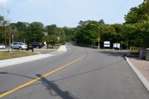
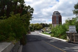
The 10:30 am. Oct. 18 walk will begin close to the Humber River bridge at the foot of Old Mill Road.
Please let Jaan Pill know – at jpill@preservedstories.com or by text at 416-722-6630 – if you plan to attend the MCHS ’60s Reunion Brunch at Old Mill Toronto, at $35 a person.
We need to let the Old Mill Restaurant know – by Oct. 11 – how many people are attending the Brunch, which starts at 11:00 am on Sunday, Oct. 18.
Our 30-minute Humber River Walk starts at 10:30 am on Sunday, Oct. 18 near the bridge that crosses the Humber River near Old Mill Toronto. The walk requires no reservation; we’re expecting a small group of conversationalists will turn up.
The walk is in the nature of a walking conversation. It’s not a walking lecture but will include a 5-minute overview of the history of the area around Old Mill Toronto based on the following details. My own interest in local history dates back to a local heritage preservation project that I became involved with October 2010.
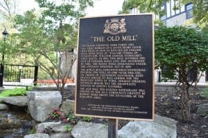
Plaque at Old Mill Toronto (see photo on right)
The text on a plaque at Old Mill Toronto reads:
The ruins standing here today are all that remain of a [seven-storey] flour mill built in 1848 to replace an earlier mill, both built by William Tyrell of Weston for William Gamble, Etobicoke’s first reeve. In 1881, this mill suffered the fate of earlier mills and was destroyed by fire. The mills were designated under the Ontario Heritage Act in 1983.
The King’s Mill, Toronto’s first industrial building, was built in 1793 near this site, on order of Lieutenant Governor John Graves Simcoe, to mill lumber for the proposed town of York. German-speaking Nicholas Miller was the millwright, assisted by the Queen’s Rangers.
The Old Mill Tea Garden Restaurant was opened in 1914 as a community amenity by Robert Home Smith, the developer of the Kingsway area.
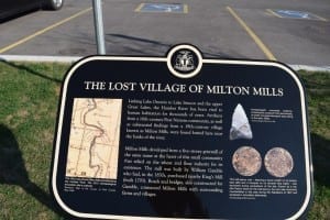
Lost Village of Milton Mills. The plaque is located along Old Mill Road just south of the parking lot.
Erected by the Etobicoke Historical Board and the Etobicoke Historical Society with the assistance of the Ontario Heritage Foundation.
[End of text]
Two ‘Lost Village of Milton Mills’ plaques are located near Old Mill parking lot
Text from the first plaque reads:
Linking Lake Ontario to Lake Simcoe and the Upper Great Lakes, the Humber River has been vital to human habitation for thousands of years. Artifacts from a 16th-century First Nations community, as well as substantial findings from a 19th-century village known as Milton Mills, were found buried here near the banks of the river.
Milton Mills developed from a five-storey gristmill of the same name at the heart of this small community the relied on the wheat and flour industry for its existence. The mill was built by William Gamble who had, in the 1830s, purchased nearby King’s Mill (built 1793). Roads and bridges, also constructed for Gamble, connected Milton Mills with surrounding farms and villages.
[End of text]
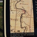
1835 map
Caption reads: “This 1835 map shows Milton Mills (circled) along the Humber River. The 2010 archaeological excavation site is outlined. [Source:] Tremaine’s Map of the County of York Canada West, 1860.”
Arrowhead image
Caption reads: “Archaeologists uncovered evidence , including this Lockport Point (arrowhead) of briefly occupied aboriginal sites dating to the early 1600s. [Source:] Archaeological Services Inc.”
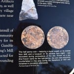
Coins
Caption reads: “This half-penny coin – featuring a laurel wreath on its reverse face (left) and a bouquet on its observe face (right) – was recovered during excavations of the site. Known as a sou (the French name for the half-penny), the coin was commonly counterfeited in this area during the rebellions of 1837 and remained in circulation afterwards. [Source:] Archaeological Services Inc.”
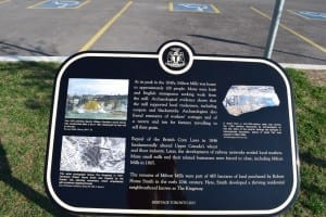
Text from the second plaque reads:
At its peak in the 1840s, Milton Mills was home to approximately 100 people. Many were Irish and English immigrants seeking work from the mill. Archaeological evidence shows that the mill supported local tradesmen, including coopers and blacksmiths. Archaeologists also found remnants of workers’ cottages and of a tavern and inn for farmers travelling to sell their grain.
Repeal of the British Corn Laws in 1846 fundamental altered Canada’s wheat and flour industry. Later, the development of railway networks eroded local markets. Many small mills and there related businesses were forced to close, including Milton Mills in 1865.
The remains of Milton Mills were part of 485 hectares of land purchased by Robert Home Smith in the early 20th century. Here, Smith developed a thriving residential neighbourhood known as The Kingsway.
Heritage Toronto 2013
[End of text]
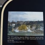
1870 painting
Caption reads: “This 1870 painting depicts William Gamble’s seven-storey mill, constructed after a fire in 1847 destroyed his first mill on the site. [Source:] Toronto Public Library, 969-1-24.
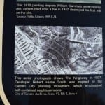
1937 aerial photo
Caption reads: “This aerial photo shows The Kingsway in 1937. Developer Robert Home Smith was inspired by the Garden City planning movement, which emphasized self-contained neighbourhoods. [Source:] City of Toronto Archives, Series 97, File 2, Item 6.”
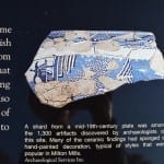
Mid-19th-century plates
Caption reads: “A shard from a mid-19th-century plate was among the 1,500 artifacts discovered by archaeologists on the site. Many of the ceramic findings had sponged or hand-painted decoration, typical of styles that were popular in Mimico Mills. [Source:] Archaeological Services Inc.”
[End of texts from two plaques on Old Mill Road between the Old Mill and the Old Mill parking lot]
50 Old Mill Road
Old Mill Toronto, which was opened in 1914, is located at 21 Old Mill Road. Another, newer building is located at 50 Old Mill Road; the planning process that preceded its construction gave rise to many discussions among area residents and decision-makers.
A Jan. 25, 2008 City of Toronto Staff Report outlining the new development is entitled:
21 Old Mill Road – Official Plan and Zoning Amendment Applications – Final Report
Additional background can be accessed at the urbantoronto.ca website:
Riverhouse at The Old Mill (Santek/Lanterra, 11s, P+S/IBI)
An additional Staff Report dated July 29, 2010, concerned with another nearby development – at 1 & 2 Old Mill Drive / 2474, 2490 and 2500 Bloor St. West – can be accessed here:
Three Old Mill roadways
Three roadways in the area are each named Old Mill, namely: 1) Old Mill Trail; 2) Old Mill Road; and 3) Old Mill Drive.

Brunch for sure.
If I have room in my carryon for sneakers I will do the walk too.
I’ve marked you down for the Brunch List, Nancy. I have a separate notebook devoted to the list.
Any shoes at all will be fine, for the walk. We are going to move at a very slow, leisurely pace. If we make it across the bridge over the Humber River and back in 30 minutes, we will do well.
I look forward to learning from you, as part of our walking conversation, about the heritage features that you most enjoy about Naples, Florida.
We are delighted that MCHS alumni from across North America will be flying in to take part in the reunion! Some of us will fly, some will drive; we are all headed for the same destination.
We also so much appreciate that you have provided embroidered MCHS crests, for each of the Grab Bags that we will distribute at the reunion, plus the centrepieces that you have kindly provided for each table, and that you have shipped to us by UPS!