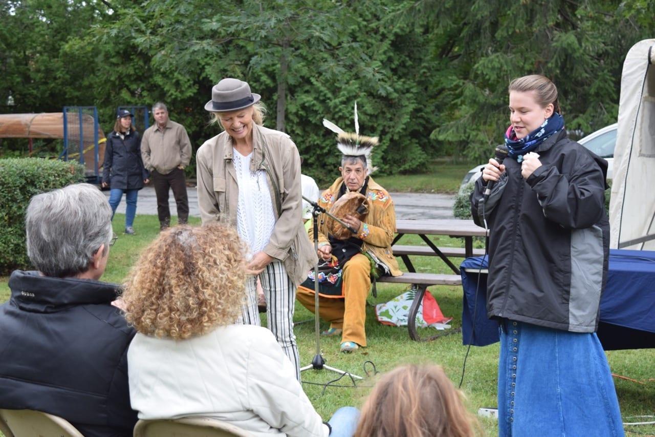
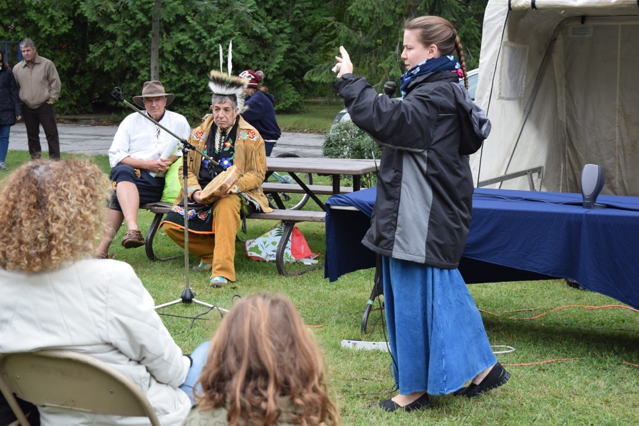
Étienne Brûlé / First Nations event took place on Sept. 13, 2015 at 222 Riverside Drive
Updates:
An April 15, 2016 Globe and Mail article by Bob Rae is entitled: “Attawapiskat is not alone: Suicide crisis is national problem.”
An April 23, 2016 CBC article is entitled: “West-end residents call for traffic light after fatal crash: Neighbour describes ‘mind-bogglingly horrendous bang’ as car hits building near Jane and Bloor.”
A Sept. 27, 2016 CBC article is entitled: “Prince William gets lesson in colonialism, cultural genocide at Black Rod ceremony: ‘The current Crown approach of deny and delay cannot continue,’ Grand Chief Ed John tells Prince William.”
A march 28, 2017 CBC article (referring to a short documentary) is entitled: “Peace River Rising: Is there a connection between violence against Indigenous women and violence against the land?”
An April 26, 2017 CBC article is entitled: “Scientists find evidence that humans were in North America 100,000 years earlier than believed: Researchers basing opinion on tools found next to mastodon site in San Diego.”
An April 26, 2017 Atlantic article is entitled: “A New Study Says Humans Were in America 130,000 Years Ago: That’s 100,000 years earlier than previously thought—and most archaeologists aren’t buying it.
An April 26, 2017 Canadian Art article is entitled: “Video: In the Studio with Kent Monkman.”
[End of updates]
Previous discussion with Scott Munro
Prior to describing the Étienne Brûlé/Wendat Expedition event that I attended on Sept. 13, 2015, I will first present a recent interview with Scott Munro (MCHS ’63).
In response to my additional questions, about the physiography of the Humber River, Scott noted that as a non-specialist in this area himself, he can only share a few thoughts picked up from the few geomorphologists that he has known during his career as a geographer.
In this post I will be discussing the Glacial Lake Iroquois shoreline; a map of the shoreline can be accessed here:
Note that you can zoom in or zoom out on the above-noted image, using the buttons at the bottom right of the map.
By way of background related to the topic at hand, a previous post is entitled:
Scott Munro (MCHS ’63) has added a comment regarding the physiography of the Humber River
Q & A
Jaan Pill: In precise terms, in what way does the current slope of Bloor Street West, as a person travels from the west, down the long hill past Old Mill Trail (where the traffic lights are), to the bridge, relate to the location of the Lake Iroquois shoreline?

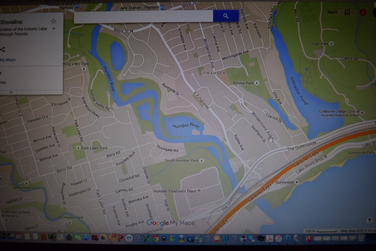
Detail: Physiography of Southern Ontario (1984) map, showing shoreline of Glacial Lake Iroquois in the Toronto area. A link to a more detailed, Google map showing the approximate location of the Lake Iroquois shoreline through Toronto is available at a link at the post you are now reading.

The image is from a screen grab (using a digital camera) of a Google Map image from the Lake Iroquois Shoreline link accessible at the post you are now reading. The dark blue line at the left, running for part of its distance roughly parallel to Dundas Street West, shows where the Iroquois Lake shoreline was located, in the area to the west of Old Mill Toronto.
Scott Munro: Assuming that you are out of the Humber Valley, it could be that you
are passing down from an old Iroquois shore toward the lake bottom. One way to get a sense of the old shoreline, aside from St. Clair Ave in Toronto, is to drive along Hwy 5 between 427 and Hurontario. Along there you will be aware of looking down on houses below, which are located on the old lake bottom.
Jaan Pill: In the context of the fact ‘the Humber River underfits its current value,’ how would a person define ‘underfits’ and what would have been the characteristics of the previous valley, that was in place before the current version? As well, do you know how the river would have come to exist in the first place, and would you know how far back the origins would have been?
Scott Munro: Basically, the valley looks a lot wider than it needs to be to accommodate the existing river flow. This could also be related to 19th century deforestation of the river valley, which tends to reduce base flow. There have been several glaciations and deglaciations in this area over the last million or so years, so it’s hard to imagine what the original valley looked like. Some people think that the Great Lakes didn’t exist as such before the ice age began.
Jaan Pill: Aside from The Physiography of Southern Ontario (1984), are there other
sources that laypersons can read, in order to gain a better understanding of
geological history as it relates to Old Mill Toronto and the surrounding area? Do you know of sources for maps that would help me to explain the geological history of the area, aside from what is available in Chapman and Putnam (1984)?
Scott Munro: You could try Eyles ‘Ontario Rocks’ to see what he has on this.
There might even be references there to other work on the topic.
[Note from Jaan: I will also try Toronto Rocks (2004) by the same author, Nicholas Eyles of the University Of Toronto, after the MCHS 2015 reunion when I have more time to explore the topic further.]
Jaan Pill: Is my introduction to the recent post correct? It reads: “The topic concerns geological processes that have occurred tens of thousands of years ago where Old Mill Toronto is now located. In geological time, the Old Mill site was once under a glacier whose thickness was measured in kilometres. When the glaciers of the last ice age were melting, the site was heavily influenced, in its physiographical features, by massive flows of water, which carved out the river valley now evident in the area.”
Scott Munro: You might substitute ‘land formation processes’ for ‘geological
processes’. Also ‘which helped to shape’ is a good substitute for ‘carved out’, as it allows for the presence of other, as yet unknown processes.
[Note from Jaan: I have now made the changes, at the previous post, that Scott has suggested.]
Comment regarding the hill that extends from east of Prince Edward Drive as you drive toward Old Mill Trail
Scott has mentioned that perhaps the hill to the east of Prince Edward Drive, as you drive toward Old Mill Trail, may be what you encounter when you move from the old Iroquois shoreline toward the lake bottom. That is a concept that I will explore in future conversations with people who are experts in geomorphology.
I recently established, by consulting a Google Map of the Old Iroquois shoreline, that the old shoreline was located near Kipling Ave. and Dundas Street West, so it’s clear that the slope that starts a ways east of Prince Edward Drive is quite a ways east of the Lake Iroquois shoreline.
The question of whether or not the hill is part of the Humber Valley intrigues me as well. The Bloor Street West hill reminds me of the hill that you travel down as you drive from Dixie Road along Lakeshore Road East in Mississauga to Forty Second Street in South Etobicoke. The latter hill appears to be connected with Etobicoke Creek; possibly the hill near Old Mill Toronto may have a similar connection with the Humber River.
A related question concerns the geomorphological processes that would have given rise to the hill that is evident as you drive down Riverside Drive from Lucy Maud Montgomery Park to South Kingsway. How did the hill come to be, exactly? What forces and processes were at play?
The search for information regarding the hill is of much interest to me: What is the available evidence; and how is the story, that relates to the evidence, framed?
Some related topics are of interest, of course, and quite a bit of evidence is available. The topics include how the universe began, how the planet Earth came to be formed, and how the human species got started and developed through a process of evolutionary biology. An enjoyable related topic, namely the meaning of human existence, has been approached anew by each succeeding generation, in the history of the human race.

An Étienne Brûlé / First Nations event on Sept. 13, 2015 took place at Lucy Maud Montgomery Park at 222 Riverside Drive on the eastern ridge of the Humber River between Bloor Street West and The Queensway. The map is oriented toward the south so that Lake Ontario can be seen on the horizon at the top of the page. The map that follows below is oriented toward the north.
Étienne Brûlé / First Nations event at Lucy Maud Montgomery Park on Riverside Drive
My involvement with local history projects in Long Branch in South Etobicoke led me to become involved with the networking, following an email from Edith George, related to the commemoration of the 400 anniversary of the Étienne Brûlé / Wendat Expedition of 1615. I’ve described the project at an earlier post:
I’ve done some online networking in connection with the project; I’m pleased I’ve been able to help out in that way. However, because I’ve been focused on a high school reunion taking place in Toronto on Oct. 17, 2015, I have not become much involved with blogging related to the 400th anniversary.

The Sept. 13, 2015 commemorative event that I attended took place at Lucy Maud Montgomery Park, located at 222 Riverside Drive on the eastern ridge of the Humber River, south of Bloor Street West and north of the Queensway.
From the time that I’ve heard about the planning for the events related to the commemoration of the Étienne Brûlé’ / First Nations journey along the Carrying Place Trail, I’ve been highly impressed with the quality of the ideas, and the close attention to detail that’s been evident in the work of all of the groups that have participated in the planning.
When I observed the many events taking place at 222 Riverside Drive on Sept. 13, 2015, I was again impressed with the level of enthusiasm, and the quality of the planning, that was evident in all aspects of the occasion. Well-spoke politicians representing the municipal, provincial, and federal levels of government turned out in period costumes, and spoke succinctly and eloquently about the significance of the day.
Click on the images to enlarge them; click again to enlarge them further
As well, there was a welcome presence – which impressed and inspired me beyond measure – of First Nations representatives, who provided a sombre measure of musical accompaniment, as well as storytelling and songs. These features of the day warmed my heart. I felt very good about this, somber as the day is, I would say, when viewed from a First Nations perspective.
The event included a number of booths, including for the Ontario Historical Society, which works in close collaboration with local historical societies across Ontario. I was interested in an overview, in the Summer 2015 issue of the OHS newsletter, describing current efforts by OHS and local historical societies to develop digital programs and services. That’s a good way to go.
I’ve met many people, and have had mutually beneficial exchanges of information about local history with them, as a result of people learning about the Preserved Stories website, which features many posts about local history. Social media and face to face meetings and conversations are key elements of the same great package, when it comes to local history, in my experience. I was also pleased to have the opportunity to visit the Toronto and Region Conservation (TRCA) booth, and to pick up a brochure about TRCA Parks and a Guide to the Humber River.

Detail from the Google Map. We can see, to the west of Riverside Drive, the triangular area that is Lucy Maud Montgomery Park. We can also view the relationship between Riverside Drive and the Queensway.
This image serves as an establishing shot for the area where the park in question is located.
For the rest of this post, I will add some photos, without extensive captions. I have a need to get back to my work on the high school reunion.
Please note you can find many more photos at the TPS 12 Division Facebook Page.
Sept. 26 & 27, 2015 events
An earlier post refers to free commemorative outdoor events on Sept. 26, 2015, in the afternoon along the Humber River starting at Old Mill Toronto.
A Heritage Talk will be held on Sunday, Sept. 27, 2015 at 2:00 pm at Lambton House with doors open at noon. Christian Bode will speak about the 400th anniversary of the Étienne Brûlé/Wendat Expedition that followed the Toronto Carrying Place along the Humber River.

As you look south toward Lake Ontario, what strikes you is the wall of towers. You might think that such a wall is inevitable. It is not. In Mississauga, there is agreement: No tall towers on the Mississauga waterfront. In that city, tall towers are reserved for arterial roads and the like; they never loom above the waterfront. Jaan Pill photo

The lower reaches of the Humber River are great for paddling of canoes and kayaks. You can rent boats at a rental facility below the TTC bridge that crosses the Humber River on the way to Old Mill station. Jaan Pill photo

Riverside Drive looking north from South Kingsway. The hill going north is quite steep. When I saw it, I began at once to thing of the geomorphological processes that would have been at play, in order for such a structure to be formed. Jaan Pill photo

View looking south along Riverside Drive. Given that I’m working on a 1960s high school reunion, I was most intrigued to see what may be an unoccupied house on Riverside Drive with a weather-worn, time-worn 1960s-era (or thereabouts) car in the driveway. I can picture when the car was new, and when the house was a well-kept home. Jaan Pill photo

The car would have been a joy to drive. That;s how I would picture it.The plants strike at the house me as exuberant and thriving. Jaan Pill photo

Jaan Pill photo

Jaan Pill photo
Jaan Pill photo
Jaan Pill photo

Jaan Pill photo

Jaan Pill photo

Jaan Pill photo

Jaan Pill photo

Jaan Pill photo

Jaan Pill photo

Jaan Pill photo

Jaan Pill photo

Jaan Pill photo

Jaan Pill photo
Jaan Pill photo

Jaan Pill photo
Leave a Reply
Want to join the discussion?Feel free to contribute!