Along the shore (Jane Fairburn 2013)

Radial bridge over Hwy 2 and Etobicoke Creek approx 1927. Photo credit: Doris Durance. © Durance family and Robert Lansdale.
Update: In response to the post you are now reading, we’ve received additional information, from Jim Carr and Catherine O’Marra, regarding the motorcycle featured in the photograph.
[End of update]
A recent project has involved tracking down information related to the photograph on this page.
The caption refers to the radial bridge over Highway 2 and Etobicoke Creek approximately 1927. An earlier version of the caption referred to a Highway 1 but I’ve since determined, with help from Robert Lansdale, that the reference to Highway 1 was a typo.
We seek additional details related to the photo
Can you provide any other information about the identities of the people in the photo, and their roles? Please contact me if you have additional information related to any aspect of the photo.
As with many photos, of particular interest is evidence related to the back story that goes with the photo.
You can enlarge the motorcycle photo by clicking on it. You can enlarge it further by clicking on it again. We owe thanks to the Durance family of Long Branch for sharing the photo with us.
I’ve written elsewhere about the Queen Elizabeth Way and the Middle Road Bridge.
Some details about the history of Ontario highways
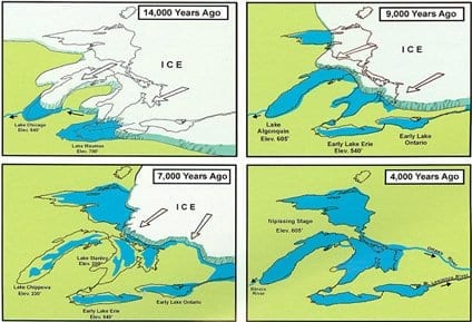
The image is from a March 14, 2017 tweet by Katherine O’Reilly @DrKatfish who writes: The lakes formed at the end of the last glacial period ~14,000 yr ago as retreating ice sheets carved basins into the land #GreatLakesWeek pic.twitter.com/JDCF0gjEDQ. Click on the image to enlarge it.
The following information is from The King’s Highway website.
Q. Did Ontario ever have a Highway 1?
A. Ontario did not ever legally designate a Highway 1. The highway numbering began at Highway 2.
Q. Why does Ontario not have a Highway 1?
A. The exact reason is not clear, but reportedly, Highway 1 was omitted from the 1925 route numbering system to eliminate conflicts between many of Ontario’s larger towns, who all demanded to be on a highway bearing the route number “1”. Given the geographic shape of Ontario, it would have been impossible for the Department of Highways to number a route that would pass through every major town in Ontario. Rather than risk any accusations of favouritism, the Department decided that they would simply not designate a Highway 1, and thus began the route numbering at 2.
Along the shore (2013)
Through talking with Jane Fairburn, I’ve been getting a good sense of the work that’s involved in the production of her upcoming book, Along the shore. The book is concerned with the communities in the Toronto area that face Lake Ontario.
Such a book has some straightforward requirements, in my perception as a reader. It needs to:
- Address the history and geography
- Keep in touch with the reader
- Sustain the reader’s interest
- Cover the ground in a coherent path, and
- Move along at a good clip
Jane Fairburn excels at these tasks. She’s a role model for any person seeking to put together a book related to local history.
She has all the key ingredients in place:
- Writing and networking skills
- Capacity to get things done
- Ongoing feedback from editors
- Sufficient time for research
- A knowledge of the market: A book aimed at readers in all of the Toronto-area communities facing Lake Ontario will reach more readers than a book focusing on just one of them
I look forward with interest to the launch of this book.
Sweet Seas (2013)
Mark Schacter is the author of a recent book, The Sweet Seas (2013), concerned with a related topic, namely the Great Lakes. A blurb at the Toronto Public Library website notes:
“When the first European explorers saw The Great Lakes they called them les mers douces – the sweet seas. They had never before encountered anything comparable. For the First Nations the Great Lakes have long been places of wonder and mystical power. And today the Lakes still have an ability to fascinate. Acclaimed photographer Mark Shachter travels the Great Lakes system to produce a personal portrait of the lakes and their surrounding towns, cities, ports, industrial zones and landscapes.”
Leave a Reply
Want to join the discussion?Feel free to contribute!